Charleston’s cobblestone streets fascinate residents and visitors alike, inspiring visions of pirates and horse-drawn carriages rattling through ye olde colonial capital. Imported from Europe as ship ballast since the 1670s, these roundish stones provided the city’s earliest street covering, but the campaign to pave local thoroughfares with cobbles didn’t commence until the early 1800s. To better understand the traveling conditions endured by early Charlestonians, let’s take a stroll through paving history from colonial times to the American Civil War.
Paving history might not sound like a topic to engross one’s imagination, but I see it as required material for anyone trying to conjure a mental snapshot of the sights, sounds, and smells of the distant past. To see beyond our modern preconceptions, we need to understand the lay of the land, both literally and figuratively. The first permanent settlement in modern South Carolina, established in 1670s and now called Charles Towne Landing State Historic Site, functioned as a base camp for Europeans eager to explore the surrounding Lowcountry. Their initial forays into the wilderness followed footpaths created by roaming quadrupeds and Indigenous people, but they also blazed new trails to facilitate their colonial endeavors.

In the early days of European settlement, South Carolina’s provincial legislature was the only body empowered to manage and regulate public pathways, both in the capital and across the countryside. The nascent government, composed of both appointed and elected freemen, collected almost nothing in the way of taxes from European settlers, and, consequently, provided very few of the myriad public services we take for granted today. The process of creating the extensive network of streets, roads, and highways within modern Charleston County accumulated slowly over numerous generations.
The first premeditated step in this long evolution occurred in the spring of 1672, when Governor John Yeamans ordered the Surveyor General of the Province to lay out a new settlement on the peninsula called Oyster Point, between the rivers Ashley and Cooper. The resulting “Grand Model” of the proposed town (described in Episode No. 245) included twelve of the oldest streets within the present City of Charleston. The surveyor’s team hammered wooden stakes into the ground to outline the streets and building lots of the new capital, and they might have cut down a number of trees to facilitate their work, but the earliest settlers of “New Charles Town” (as it was called in 1680) lived within a shady maritime forest that gradually diminished as the community matured.
In April 1685, for example, the South Carolina legislature ratified a law requiring the owners and proprietors of lots within urban Charles Town to remove “all bushes, young pines and weeds” standing on their property, and also to “clear, stubb upp and remove all bushes, stumpes, young pines, and weeds” from the street directly in front of their respective properties.[1] A similar law, ratified in October 1698, required urban residents to “raise and mend” a sidewalk along the front of their respective properties by depositing a linear path of “broken oyster shells,” six feet wide.[2]
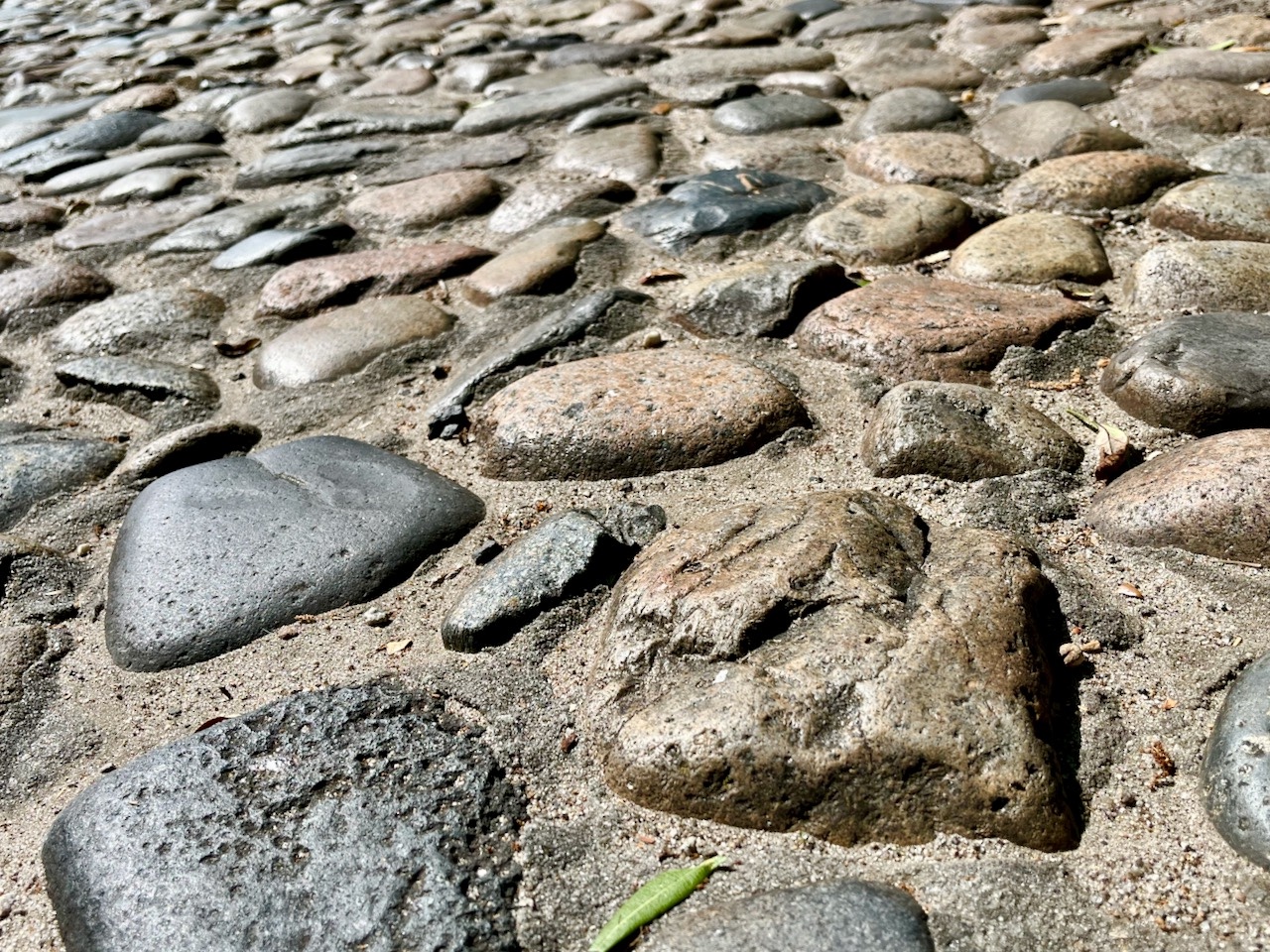
Local lore fabricated in the twentieth century asserts that the streets of colonial-era Charles Town were paved with ballast or “cobble” stones discarded by trans-Atlantic vessels visiting the port, but a long trail of archival documents provides robust evidence to the contrary. Beginning in the spring of 1696 and continuing through the end of the American Revolution, South Carolina’s provincial government appropriated all discarded ballast stones, often called “shingle ballast,” for use as riprap to protect the eastern ramparts of the town’s waterfront fortifications (see Episode No. 181). We’ll discuss the role of ballast stones in the expansion of the town’s colonial defenses in future programs, and we’ll circle back to cobblestone paving shortly, but for the moment we’ll continue with the chronological narrative.

By the beginning of the eighteenth century, there was still no public agency responsible for maintaining the streets of South Carolina’s provincial capital, much less improving them. The streets of early Charles Town were dirty, sandy, and occasionally muddy, vestigial reminders of the former maritime forest cleared by the early generations of townsfolk. Not surprisingly, Governor Nathaniel Johnson complained to the provincial legislature in November 1706 about the unhealthy, “nasty keeping of the streets in the town” and other public deficiencies in urban Charles Town.[3] The colonial General Assembly responded in April 1710 by creating the office of “scavenger in Charles Town” to remove rubbish and filth from the urban streets, but otherwise the government did little to improve the capital’s curb appeal for many more years.[4]
Also during the early the eighteenth century, the provincial legislature authorized the opening of several rural roads—like modern Bee’s Ferry Road—to facilitate vehicular traffic across the sparsely-populated Lowcountry. Planters residing near each road were responsible for using their own enslaved laborers to create and maintain these public highways, but the lack of statutory enforcement retarded their progress. An improved highway law ratified in September 1721 created a board of Commissioners of High (or main) Roads for each of the parishes within the province. Laborers drawn from abutting plantations were still required to perform periodic maintenance on rural roads, but they were supervised by a local board of road commissioners until the late nineteenth century.[5]
Meanwhile, back in urban Charles Town, a provincial law ratified in February 1724 required the owner or proprietor of every lot abutting the capital’s principal streets (i.e., Broad, Tradd, Queen, Church, and Meeting Streets) to help reshape the public right-of-way. By swinging their own tools or providing enslaved servants, residents were obliged to “draw the dirt from the middle of the street up towards their respective lotts, with an ascent from the middle of the said street.”[6] This mandatory labor created urban thoroughfares with a concave profile, like those seen in contemporary England, in which rainwater, leaf litter, and horse dung collected in the center of the streets. The subsequent creation of rudimentary subterranean drains under the center of various streets, a project that commenced in Broad Street in 1735, removed some of the collected filth, but concave streets with central gutters persisted in Charles Town for a further century.[7]
The next significant development in local street history occurred in May 1750, when the South Carolina General Assembly ratified “An Act for keeping the Streets in Charles Town clean.” This lengthy piece of legislation appointed a board of commissioners responsible for superintending street maintenance in the capital and resolving traffic issues and nuisances therein.[8] Because a horse galloping through the town’s sandy streets could raise a cloud of dust to the annoyance of pedestrians, for example, the street commissioners’ law of 1750 prescribed the urban speed limit as “a moderate trot,” a relaxing gait that persisted in Charleston until 1907. An amended version of the 1750 law, adopted in August 1764, empowered the street commissioners to begin paving the sidewalks of urban Charles Town with bricks laid in a bed of mortar. This work commenced sometime before Christmas of the same year, when the commissioners warned citizens, for the first time, not to ride horses, push wheelbarrows, or roll barrels over “any of the new-laid pavements.”[9]

The formal incorporation of the “City of Charles Ton” in August 1783 transferred the board of Commissioners of Streets and all responsibility for the capital’s urban thoroughfares to the newly-formed City Council.[10] Municipal leaders perpetuated colonial-era practices to clean and drain the city’s streets, but the expanding grid of sandy thoroughfares remained largely unimproved well into the nineteenth century. There was, however, one abortive experiment to launch a street paving campaign in 1792. In July of that year, Council ratified an ordinance to levy paving expenses on the several owners of property abutting the streets in question. Evidence of their progress, if any was made, unfortunately disappeared along with most of the city’s early municipal records in the “Great Memory Loss of 1865.” Urban residents of the late eighteenth century probably witnessed no benefit from the abutting property law of 1792, as a new administration repealed the city’s first paving ordinance less than two years later. Although that concession deferred the dream of street improvement for a further generation, the idea of distributing the costs among the owners of abutting property became an important theme of later, more successful paving efforts.[11]
Charleston’s City Council laid the groundwork for further improvement in 1806 by augmenting the purview of the urban street commissioners, rebranded in November of that year as the board of Commissioners of Streets and Lamps with enhanced, proactive powers.[12] President Thomas Jefferson’s imposition of a national embargo against trade with Great Britain in January 1808 crippled the local economy, and likely deflated any municipal dreams of street paving in the port city of Charleston.
Shortly before the formal declaration of war in 1812, the South Carolina General Assembly created a new body to administer a select portion of the suburban roads on Charleston Neck, the unincorporated area north of the city limit at Boundary Street (now Calhoun Street). While the old Commissioners of High (or Main) Roads for the Parish of St. Philip, created in 1721, continued to maintain the principal north-south routes through Charleston Neck (i.e., Meeting Street Road, King Street Road, and the northward extension of Rutledge Avenue), the new Commissioners of Cross Roads on the Neck were henceforth responsible for all east-west thoroughfares (like Columbus Street, Spring Street, and Cannon Street) and other minor roads immediately north of the city limits.[13] Although this hodge-podge of jurisdictions might seem superfluous to the present conversation, their interdependence played an important role in the slow paving progress of Charleston’s northernmost suburbs.
Following the long economic depression surrounding the War of 1812, City Council resolved in the spring of 1817 to launch a campaign to pave its first street. Their target was the Charleston’s busiest commercial thoroughfare, East Bay Street, which was daily crowded with pedestrians and vehicles carrying heavy freight to and from ships docked along the wooden wharves projecting eastward into the Cooper River.[14] Civil engineer Charles Parker (1797–1859), a young man at that time, later recalled that East Bay Street retained its colonial-era profile into the early years of the nineteenth century, describing its unpaved surface as a basin of “concave earth” that became “a mud hole” during periods of wet weather.[15]
Because there were no sources of durable stone within a hundred miles of Charleston, the city proposed to pave the streets using cobbles transported from Europe as ballast. The city had been well-stocked with discarded ballast for more than a century by this point, but there wasn’t a sufficient supply for paving purposes after the War of 1812. Much of the local ballast was likely consumed in City Council’s long campaign to create East Battery Street, an expensive waterfront project that commenced in 1785 and persevered through multiple setbacks until the completion of the High Battery seawall in 1818. Around that time, the city began purchasing supplies of ballast stones from Northern suppliers specifically for use in street paving.[16]

In January 1818, City Council moved forward with its plan to pave the oldest and busiest stretch of East Bay, from the Missroon House (No. 40 East Bay Street) to Mey’s Wharf (i.e., modern Pritchard Street, adjacent to The Hard).[17] City Surveyor John Wilson advised Council at that time to adopt the “best mode of paving” established by experience “in both Europe and America”; that is, “a convex form, with side gutters” and a crown or peak in the center of the street. Wilson specified that the “shingle ballast” or cobblestones were to be laid in a deep bed of local sand and “levelled with beat [i.e., pulverized] oyster shells” to provide a reasonably smooth surface. The paving work probably commenced around the middle of 1818, at which time City Council resolved to extend the cobblestone paving into Vendue Range, at the east end of Queen Street.[18] The paving work continued through the following winter and perhaps concluded in January 1819, when local officials affixed an engraved memento of their labors to an old iron cannon that was planted in the ground as an upright bollard near the northeast corner of East Bay and Broad Streets.[19]
In the years following the completion of Charleston’s first street paving project along the waterfront, city officials proceeded to address other thoroughfares within their jurisdiction, but the great expense constrained their efforts to the streets carrying the heaviest commercial traffic. City contractors began laying beds of imported cobblestones in Broad, Queen, and Tradd Streets in December 1821, extending the lumpy paving from East Bay westward to King Street.[20] Elliott Street was also paved with cobblestones around 1822, but somehow retained its old concave profile. While the city paid workers to remove, regrade, and re-lay the Elliott Street cobbles in a convex form in 1824, the residents of lower Tradd Street chose to retain the old concave profile for several more decades.[21]
Charleston’s City Council of the Antebellum era devoted far less attention to the lanes, alleys, and streets dominated by residential traffic, but municipal authorities did not completely ignore the needs of pedestrians and lighter vehicles. In the autumn of 1822, city workers began experimenting with a new mode of street paving then becoming popular in England and the Northern States.[22] Widely-read essays on road construction by Scottish engineer John Loudon McAdam promoted a relatively inexpensive mode of paving using layers of angular stone of graduated sizes. Like the creators of ancient Roman roads, McAdam recognized that the successive layers of angular stones compacted into an interlocking matrix superior to roads composed of roundish stones. The loss of most of Charleston’s early municipal records in 1865 frustrates our ability to understand the scope of McAdam (or “macadam”) street paving during this era, but the city definitely adopted the practice to some extent. Although the stones had to be purchased from foreign ships docked in Charleston or transported from Northern States, the city saved money from 1837 to 1865 by requiring inmates of the municipal Work House (that is, enslaved men and women confined for punishment) to spend their hours “cracking stones, for grading and macadamizing the streets.”[23]
The next significant development in the history of local street paving occurred in the autumn of 1836, when Charleston’s municipal government replaced its part-time, unsalaried intendent with a full-time, salaried mayor (see Episode No. 130). The executive officer was henceforth required to publish an annual report describing the achievements of city government and their plans for the coming year. Thanks to this advance in public transparency, robust details of city improvements survive from the fifteen years preceding the outbreak of the Civil War.
Under Charleston’s first mayor, Robert Hayne, Council created a “Committee on City Improvements” in September 1836 and outlined a raft of public projects—including the creation of White Point Garden—to modernize and beautify the old Southern seaport. Among the changes was a new mode of roadwork, adopted in August 1837, that mandated the reshaping of city streets from concave to convex profiles, covering them “with [oyster] shells, or other suitable materials (except stone),” and for assessing the cost of paving, drainage, and sidewalk construction on the owners of property abutting the streets in question.[24]

Mayor Hayne’s first road project focused on Meeting Street, but his one-year term ended before the project was completed. In August 1838, Mayor Henry Laurens Pinckney reported that Meeting Street, from South Bay to Boundary (Calhoun) Street, as well as “portions of Broad street, King street and South Bay” had been paved with mix of “limestone, obtained from Ashley River [i.e., soft phosphate rock], Bermuda rock and broken bricks and mortar, thickly intermixed with that small species of stone, usually denominated shingle ballast,” all topped by a layer of crushed oyster shells. When compressed by vehicular traffic, said Pinckney, these components formed a “cemented and consolidated mass, admirably firm and durable,” while the oyster shell covering “greatly improved the appearance of the street, by rendering the surface uniformly beautiful and smooth.”[25]
Although some residents complained about the solar glare reflecting off the pearly white surfaces of Charleston’s newly-improved streets, and other citizens complained about the clouds of lime dust rising from the bed of pulverized oyster shells, the municipal government was hard-pressed to effect any further improvements for nearly a decade.[26] The so-called Panic of 1837, a national financial crisis that crippled Charleston’s economy, sank the raft of optimistic projects initiated by Mayors Hayne and Pinckney and retarded the city’s progress throughout the 1840s.
Anyone familiar with the twenty-first century retail extravaganza called King Street might assume that the thoroughfare has always ranked high among the city’s priorities. Such was not the case in antebellum times, however, when shopping residents and country visitors drove carriages, rode trotting horses, or walked along the narrow colonial street to make their commercial purchases. In the eyes of City Council, the relatively light traffic in King Street did not merit the expense of robust cobblestone paving. In August 1848, after a fallow decade of street improvements, Council finally ordered King Street to be “macadamized” from Broad to Boundary Street (renamed Calhoun in October 1850).[27]
Meeting Street, on the other hand, developed into a bustling thoroughfare after the construction of an extensive railroad depot near the center of the peninsula, stretching from Mary Street southward to John Street. To move freight between the train depot and the Cooper River waterfront, east of East Bay Street, teamsters of the 1840s and beyond drove heavy wagons, carts, and drays, down Meeting Street to various cross streets leading to the commercial wharves. To improve the dirty, oyster-shell street and to expedite valuable commercial traffic, Charleston’s City Council spent the bulk of its annual paving budget in several successive years to transform Meeting Street into the city’s principal urban highway. In 1849, contractors removed the twelve-year-old oyster-shell mix from the blocks between Calhoun and Market Streets to lay a swathe of cobblestones in its stead. Between late 1852 and early 1853, contractors repaved Meeting Street between Market and Queen Streets with cobblestones, followed shortly thereafter by the stretch from Queen to Broad Streets. Beginning in the autumn of 1857, workers cobbled the blocks leading from the railroad depot in Mary Street to Calhoun Street. The southernmost blocks of Meeting Street, south of Broad Street, were purely residential, however, and did not merit expensive paving until many years later.[28]

The heavily-used eastern portions of Broad, Tradd, and Wentworth Streets, as well as Pinckney, Hayne, and George Streets, received cobblestone updates in the early 1850s, as did a relatively insignificant street with a commercial connection. Chalmers Street, created in 1823 by widening, straightening, and combining Chalmers Alley and Beresford Alley, received its first cobble paving in the autumn of 1852 because it had become a shortcut for heavy freight passing to and from the commercial waterfront. The stone surface of Chalmers Street survived well into the twentieth century, becoming a tourist attraction that we’ll revisit in the second part of this narrative.[29]
The last remaining aspect of Charleston’s antebellum paving history draws our attention northward, to the boundary line between the incorporated city and the unincorporated Neck. In the summer of 1849, the Commissioners of Main Roads for the Parishes of St. Michael and St. Philip announced their intention to create a smooth highway in both King Street Road and Meeting Street Road, extending from Marion Square to the intersection of both roads, two miles northward, a point called “the Forks,” near modern Cunnington Street. The suburban roads were to be built of broad wooden planks nailed to a bed of 4-by-4 wooden sleepers embedded in the dirt. Construction of Charleston’s first plank road, the latest fashion in American road building at the time, commenced in October 1849 near Hutson Street, adjacent to the old Citadel campus, but soon ran into a political quagmire.[30] The City of Charleston, empowered by state law, commenced in January 1850 to annex all of the land from Calhoun Street to a new municipal boundary called Mount Pleasant Street, near the forks of the main roads. This political maneuver, described by some contemporaries as a hostile takeover, forced city officials to negotiate with the suburban Commissioners of Main Roads in order to salvage the dual plank road project. Laborers paid by City Council completed the two two-mile stretches from Marion Square to the Forks by the spring of 1852, while the rural road commissioners extended Meeting Street Road a further three miles to the Six Mile House, near Success Street in the modern City of North Charleston.[31]
Charleston’s municipal government of the early 1850s also authorized the construction of several short plank roads linking various cross streets to the larger plank highways. A few more plank roads appeared in waterfront neighborhoods like Harleston and Hampstead, but most extensive example within the lower part of the city might surprise modern residents. In the summer of 1852, Council authorized the construction of a dual-track plank road in Broad Street, extending from the cobbles of Meeting Street westward to Rutledge Avenue, then turning northward and continuing to Line Street.[32] Beyond these short-lived projects built of perishable materials, the city gradually expanded the range of cobblestones and macadam roadbeds until the clouds of Civil War stifled the supply of paving materials.
In the next edition of Charleston Time Machine, we’ll pick up the paving thread with the wreckage of post-war streets and trace the rise of granite blocks, vitrified bricks, and sheets of continuous asphalt. Most of the city’s streets remained unpaved at the turn of the twentieth century, a fact underscoring the community’s poverty during the turbulent era of Reconstruction and Jim Crow. Until next time, keep it smooth, Charleston!
[1] See Act No. 25, “An Act for the clearing the lotts and streetes of Charles-town, and for the settlement and regulation of a night-watch in the said towne,” ratified on 11 April 1685, in David J. McCord, ed., The Statutes at Large of South Carolina, volume 7 (Columbia: A. S. Johnston, 1840), 1–3. In this and subsequent quotations, I have reproduced the spelling contained in the original source.
[2] See section 20 of Act No. 162, “An Act for settling a Watch in Charles Town, and for preventing of Fires,” ratified on 8 October 1698, in McCord, Statutes at Large, 7: 7–12.
[3] A. S. Salley Jr., ed., Journal of the Commons House of Assembly of South Carolina, November 20, 1706–February 8, 1706/7 (Columbia: The State Company for the Historical Commission of South Carolina, 1939), 5.
[4] See section 11 of Act No. 294, “An Act to appoint and erect a Market in Charles Town, for the Publick sale of Provisions, and against Regrators, Forestallers and Ingrossers,” ratified on 8 April 1710, the text of which appears in Nicholas Trott’s manuscript “New Collection” of early laws at the South Carolina Department of Archives and History (hereafter SCDAH), pp. 31–38.
[5] See Act No. 442, “An Act to empower the several Commissioners of the High Roads, private paths, bridges, Creeks, causeys, and cleansing of water-passages, in this Province of South Carolina, to alter and lay out the same, for the more direct and better conveniency [sic] of the inhabitants thereof,” ratified on 15 September 1721, in David J. McCord, ed., The Statutes at Large of South Carolina, volume 9 (Columbia: A. S. Johnston, 1841), 49–57.
[6] See the final section of Act No. 480, “An Act for the keeping and Maintaining a Watch and Good Orders in Charles Town,” ratified on 15 February 1723/4, which is found among the engrossed acts of the General Assembly at SCDAH.
[7] See Act No. 588, “An Act for sinking a Drain in Broad-street, in Charlestown, and for cleansing and regulating the said street,” ratified on 29 March 1735, the full text of which survives among the engrossed acts of the General Assembly at SCDAH.
[8] See Act No. 775, “An Act for keeping the Streets in Charles Town clean, and establishing such other regulations for the security Health and Convenience of the Inhabitants of the said Town as are therein mentioned, and for establishing a new Market in the said Town,” ratified on 31 May 1750, the full text of which survives among the engrossed acts of the General Assembly at SCDAH.
[9] See Act No. 927, “An Act to Empower Certain Commissioners therein mentioned, to keep clear and in good order and repair the streets of Charlestown; and for establishing other regulations in the said town,” ratified on 10 August 1764, the full text of which survives among the engrossed acts of the General Assembly at SCDAH; South Carolina Gazette, 8–15 October 1764, page 1; South Carolina Gazette, 24–31 December 1764, page 1. Note that writers in late-eighteenth and early nineteenth-century Charleston consistently used the term “pavement” in reference to sidewalks rather than street paving.
[10] See section 4 of Act No. 1191, “An Act to Incorporate the Charleston,” ratified on 13 August 1783, in McCord, Statutes at Large, 7: 98.
[11] See “An Ordinance to provide for the Paving of the Streets of Charleston,” ratified on 13 July 1792, and “An Ordinance for appointing Commissioners of the Streets and defining their powers, and for other purposes therein mentioned,” ratified on 24 February 1794, in [Charleston, S.C.] City Gazette, 18 July 1792, page 3; and City Gazette, 27 February 1794, page 2.
[12] See “An Ordinance to define the powers of the Commissioners of the Streets and Lamps in the City of Charleston, and for other purposes therein mentioned,” ratified on 20 November 1806, in Alexander Edwards, comp. Ordinances of the City Council of Charleston, Passed between the 24th of September 1804, and the 1st Day of September 1807 (Charleston, S.C.: W. P. Young, 1807), 407–22.
[13] See section 32 of Act No. 1994, “An Act to Establish certain Roads, Bridges and Ferries; and for certain purposes therein mentioned,” ratified on 21 December 1811, in McCord, Statutes at Large, 9: 455–60.
[14] City Gazette, 17 July 1817, page 2, “Communication.”
[15] Charles Parker, Essays on Reflected Heat in Cities, Shading by Trees, Sidewalks, and Carriage Ways (Charleston, S.C.: Walker and Burke, 1848), 9.
[16] Charleston Courier, 4 April 1817, page 2, “Wanted Immediately, Four thousand tons of Paving Stone, for the centre of streets”; City Gazette, 25 May 1818, page 2, “The ship Henry, arrived on Saturday from New York, has a cargo of paving stones, for paving East Bay street”; Karl Bernhard, Duke of Saxe-Weimar-Eisenach, Travels Through North America During the Years 1825 and 1826, volume 2 (Philadelphia: Carey, Lea & Carey, 1828), 4; MSS Journal of the Commissioners of Streets and Lamps, 1806–18, meeting of 3 July 1818, presently held within the Charleston Archive at the main branch of the Charleston County Public Library.
[17] City Gazette, 9 January 1818, page 2, “East-Bay-Street.”
[18] Wilson’s recommendations, dated 7 January 1818, appear under the meeting minutes of 21 January 1818 in the manuscript Journal of the Commissioners of Streets and Lamps, 1806–1818, at CCPL. References to the paving of Vendue Range appear in the same volume under the date of 3 July 1818.
[19] City Gazette, 29 December 1818, page 2, “Laborers Wanted”; Charleston Daily Courier, 9 August 1862, page 1, “A Relic.”
[20] Courier, 15 September 1821, page 3, “Office of Comm’s. Streets and Lamps.”
[21] City Gazette, 26 May 1824, page 3, “City Contracts”; City Council proceedings of 31 March 1840, printed in Courier, 3 April 1840.
[22] For a brief discussion of “a system of road making practiced in England by John Loudon McAdam,” see the City Council minutes of 10 June 1822 (page 79), and 27 August 1822 (page 102), in the fragmentary manuscript volume of “rough minutes,” 1821–22, now held by the Charleston Archive at the main branch of CCPL.
[23] See “An Ordinance to alter and amend an ordinance entitled ‘An Ordinance to provide for the due regulation of the Work House in the City of Charleston,’” ratified on 16 October 1837, in George B. Eckhard, comp., A Digest of the Ordinances of the City Council of Charleston, from the Year 1783 to October 1844 (Charleston, S.C.: Walker & Burke, 1844), 310.
[24] See “An Ordinance to amend the law on the subject of drains, pavements, side walks, and leveling and keeping the public streets in order, and concerning trees in said streets,” ratified on 29 August 1837, in Courier, 4 September 1837, page 1. Note that Abram Blanding, Superintendent of Public Works, communicated to the state legislature in December 1826 a report of experiments using oyster shells as a road covering on the public road leading to Charleston; see SCDAH, Miscellaneous Communications to the General Assembly, 1826, No. 8.
[25] [Henry Laurens Pinckney], Report: Containing a Review of the Proceedings of the City Authorities, from the 4th September, 1837, to the 1st August, 1838, with Suggestions for the Improvement of the Various Departments of Public Service. Presented to the City Council, August 6, 1838, by Henry L. Pinckney, Mayor (Charleston, S.C.: Thomas Eccles, 1838). 17–18.
[26] See [Charleston, S.C.] Southern Patriot, 27 July 1839, page 2, “City Improvements”; City Council proceedings of 12 August 1839 in Courier, 14 August 1839;
[27] See the City Council proceedings of 22 August 1848 in Southern Patriot, 25 August 1848, page 2.
[28] City Council proceedings of 14 November 1848 in Courier, 15 November 1848, page 2; City Council proceedings of 12 December 1848 in Courier, 14 December 1848, page 2; City Council proceedings of 29 December 1848 in Courier, 1 January 1849, page 2; Courier, 17 January 1849, page 2, “Clerk’s Office, City Hall, Jan. 17”; Courier, 24 November 1851, page 3, “Mayor’s Office, Nov. 24, 1851”; Courier, 23 September 1852, page 3, “Clerk’s Office, City Hall, Sept. 23, 1852”; City Council proceedings of 5 October 1852 in Courier, 7 October 1852, page 2; Courier, 1 August 1857, page 2, “Notice.—To Contractors.”
[29] Courier, 5 November 1849, page 2, “Clerk’s Office, City Hall, Nov. 1, 1849”; City Council proceedings of 28 December 1849 in Courier, 31 December 1849, page 2; Courier, 1 March 1850, page 3, “Clerk’s Office, City Hall, Feb. 28, 1850; Courier, 14 May 1850, page 2, “Clerk’s Office, City Hall, May 10, 1850; City Council proceedings of 28 July 1852 in Courier, 31 July 1852, page 1; Courier, 16 August 1852, page 3, “Mayor’s Office, Aug. 12”;
[30] Courier, 13 July 1849, page 3, “To Lumber Dealers”; Courier, 8 August 1849, page 3, “The Commissioners of Main Roads for the Parishes of St. Philip and St. Michael”; Courier, 24 October 1849, page 2, “Plank Roads”; Courier, 25 October 1849, page 3, “Plank Roads.”
[31] See “An Ordinance to enlarge certain Boards and Departments, and to extend and adapt certain Laws and Regulations to that part of the Parish of St. Philip which has been recently incorporated with the City of Charleston, and for other purposes,” ratified in 19 October 1850, in H. Pinckney Walker, comp., Ordinances of the City of Charleston, from the 19th of August 1844, to the 14th of September 1854 (Charleston, S.C.: A. E. Miller, 1854), 95–98; City Council proceedings of 1 April 1851 in Courier, 4 April 1851, page 2; Courier, 10 April 1851, page 3, “Mayor’s Office”; City Council proceedings of 27 May 1851 in Courier, 31 May 1851, page 2; Courier, 18 March 1852, page 2, “Plank Roads”; Courier, 15 June 1853, page 2, “Plank Roads”; Courier, 1 July 1853, page 1, “The New Plank Road Project.”
[32] Courier, 7 June 1852, page 3, “Mayor’s Office, June 7, 1852.”
NEXT: Reconstructing the Streets of Post-Civil War Charleston
PREVIOUSLY: Frederick Douglass in 1888 Charleston
See more from Charleston Time Machine