Market Street and its venerable public buildings exemplify the spirit of preservation and resilience in modern Charleston, but forgotten details of the site’s creation in the late eighteenth century shroud a troubled genesis. The city’s broadest thoroughfare was mostly underwater during its early years, and the site’s first edifice sheltered butchers only briefly before a distant political crisis unraveled its legal foundation.
To understand the forces that shaped the birth, dissolution, and rebirth of Market Street more than two centuries ago, and to understand how parts of this important story were deleted from the community’s collective memory, we need to explore the turbulent context in which these long-forgotten events unfolded. Let’s begin where we left off in the previous episode, when the British forces occupying rebellious Charles Town evacuated the unincorporated capital of South Carolina in December 1782.
During the colony’s first century, the provincial legislature established and maintained a series of public marketplaces within urban Charles Town, but that custodial tradition changed shortly after the restoration of the nascent state government in January 1783. On August 13th of that year, the South Carolina General Assembly ratified a corporate charter for the City of Charleston, encompassing all of the peninsular property south of Boundary Street (now Calhoun Street). The act of incorporation also transferred to the new City Council responsibility for various public properties, including three market sites—the old Beef Market at the northeast corner of Meeting and Broad Streets, the Lower Market at the east end of Tradd Street, and the Fish Market at the east end of Queen Street. Likewise, the Commissioners of the Markets, an administrative board created under the provincial government in 1736, became a municipal body in 1783.

The members of Charleston’s new City Council and employees of various municipal departments began creating and archiving hand-written records of their activities immediately after the act incorporation, but almost all of that manuscript material disappeared at the end of the American Civil War. The Great Memory Loss of 1865, as I’ve described this phenomenon, permanently abridged our ability to understand a number of important changes to the landscape of urban Charleston in the years immediately after the American Revolution and into the early decades of the nineteenth century. Although a significant volume of excerpts and anecdotes relating to municipal activities during this era survive in contemporary newspapers, municipal publications, documents submitted to the state government, and among the private papers of prominent individuals, the fragmentary nature of this material has frustrated the work of generations of historians. The task of reconstructing the genesis of Market Street, like many other stories of Post-Revolutionary Charleston, is akin to reassembling the pieces of a shattered mosaic. With these challenges in mind, let’s pick up the story in the aftermath of the War for Independence.
At the time of the city’s incorporation, the population of urban Charleston included approximately 14,000 individuals, more than half of whom were enslaved and free persons of African descent.[1] Every household in the city, regardless of its wealth or status, sent at least one person to the public markets every day (except Sunday) to purchase fresh provisions, and those shoppers navigated across an evolving landscape to procure necessary ingredients. Between 1784 and 1785, for example, city and state officials supervised laborers who demolished the brick curtain line standing along the eastern edge of East Bay Street and all of the other defensive fortifications scattered across the peninsula (see Episode No. 74). In 1785, City Council paid workers to raise and pave the ground under the Lower Market and to rebuild the adjacent vegetable shed abutting Graeme’s Wharf (south of the public marketplace). To accommodate the rising number of shoppers frequenting that demilitarized site, the city contracted in early 1786 to lengthen the Lower Market by “about 29 feet,” extending the timber-frame structure and its brick floor westward, over the site of the old redan at the east end of Tradd Street.[2] Crowds of pedestrians circulating at that location and around the Fish Market in Queen Street interrupted the flow of traffic along the narrow and crooked path of East Bay Street until late 1787, when the city government negotiated with numerous wharf owners to widen and straighten the waterfront thoroughfare to its present dimensions. Frequent auction sales of imported goods and maritime equipment at the “Market Wharf” abutting the northern edge of the Lower Market attracted even more pedestrians to the foot of Tradd Street, while the post-war resumption of ferry service across the Cooper River crowded the fishing boats delivering fresh seafood to the foot of Queen Street.

Meanwhile, a fire at the northwest corner of Meeting and Broad Streets in February 1788 reduced the South Carolina State House to a smoldering shell and endangered the fabric of the Beef Market across the street. The conflagration accelerated plans to move the state government to a new inland capital at Columbia, and evidently sparked conversations about the need to relocate Charleston’s principal flesh depot. For more than fifty years, the Beef Market had occupied the northeast quadrant of Market Square, a site regarded by earlier generations as the western fringe of the town’s commercial center. The subsequent erection of substantial public buildings on the remaining quadrants of the square, combined with the proliferation of private shops and residences in the surrounding neighborhood, rendered the butcher’s headquarters a gross anomaly fouling an increasingly gentrified streetscape in the late 1780s.
Such concerns about the site of the Beef Market inspired comparisons with the similar state of the city’s waterfront markets. One year earlier, in March 1787, the South Carolina legislature had repealed a colonial-era law that had long prohibited the construction of substantial, permanent buildings along the east side of East Bay Street. The anticipated proliferation of private edifices within that deregulated landscape would eventually envelope the already-constricted sites of the Lower Market and the Fish Market. Furthermore, the daily throngs of pedestrians and horse-drawn carts crowding the city’s three public markets routinely interrupted the flow of other streams of commerce, while wakes of hungry vultures and “great numbers of dogs” harassed market customers and occasionally went mad from gorging on discarded offal and scraps of raw meat.[3]
A potential solution to all of these defects coalesced in the minds of Charleston’s elected aldermen during the early weeks of 1788. While laborers cleared rubble from the shell of the old State House, municipal officials pondered the idea of removing all of the city’s public markets to a new, unified location somewhere within the urban landscape. The ideal site for such a reservation, or “market street,” if you will, was within walking distance of most residences, but sufficiently spacious to host a range of buildings erected in sequential fashion over a period of years to minimize the tax burden laid on city residents; a site easily accessible to horse-drawn wagons and carts filled with country produce and butchered meat, yet close enough to the waterfront to facilitate the landing of boatloads of fresh fish and other seafood.

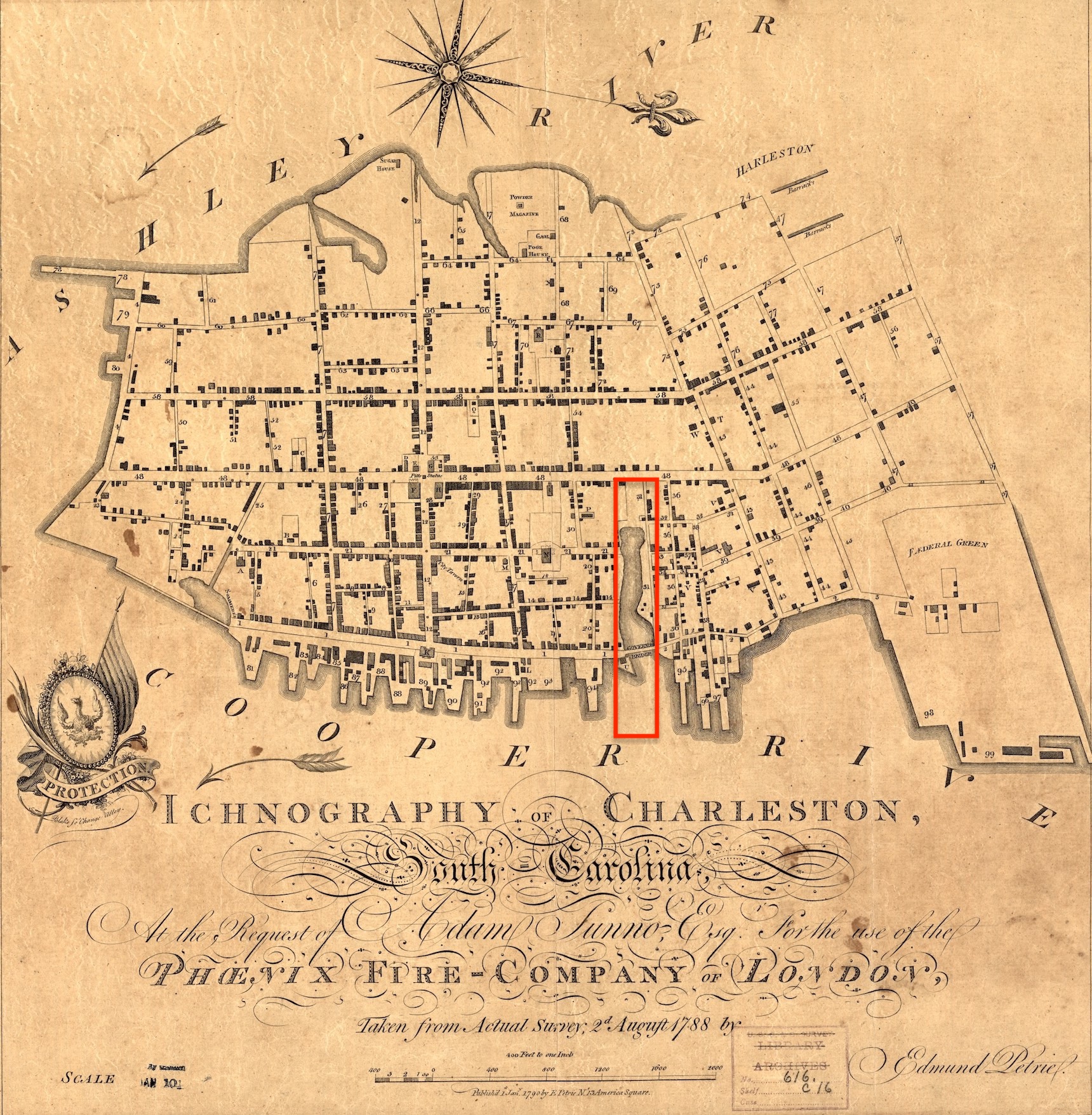
We, like Charlestonians of that era, can consider the possible sites for such a market corral by examining a detailed plan of the city made by local surveyor Edmund Petrie in August 1788, which was then engraved and published in London in 1790 under the title Ichnography of Charleston. In this map we see tracts of eligible vacant land near the southern tip of the peninsula, but the creation of a large marketplace in that area would have required all vehicles carrying country produce to pass through the entire length of the city and congregate daily within an otherwise quiet and increasingly genteel residential neighborhood. Larger swathes of vacant land appeared on the western edge of the peninsula, on or near the waterfront acreage reserved for Charleston Common, but the Ashley River was not the principal waterway for boats bringing country produce from inland plantations, or the off-shore mariners who supplied the Fish Market. There was ample vacant marshland along the Cooper River waterfront, immediately north of the Hard or Rhett’s Point, but that area, now occupied by the Harris-Teeter grocery store on East Bay Street, was too far removed from the city’s center, and not easily accessible to horse-drawn vehicles loaded with produce.
The most logical location for a new, consolidated marketplace in 1788 was the linear landscape of Daniel’s Creek, a tidal inlet flowing from the Cooper River westwardly, under Governor’s Bridge in East Bay Street (built in 1767–68), and nearly reaching Meeting Street at high tide. The watery site in question formed the southern half of Colleton Square, a nine-acre parcel granted to the Colleton family of Barbados in 1681 and then sold to a trio of investors in 1736. Led by attorney Charles Pinckney (1699–1758), the investors began subdividing the drier northern half of Colleton Square into streets and residential lots during the 1740s, while reserving the center channel of the creek as a navigable canal for the use of adjacent residents. The western end of Daniel’s Creek had once marked the northern terminus of Meeting Street, which the provincial government extended northward to George Street in 1767, and which the state government in 1785 extended several miles further into the countryside. Following the completion of that roadwork in 1786, Meeting Street Road, as it became known, gradually supplanted King Street as the principal highway leading in and out of Charleston. If the city government were to erect a market shed on the vacant patch of Colleton Square abutting Meeting Street, as municipal officials conceived in early 1788, they might anchor a more commodious public marketplace that could expand eastwardly in stages as the filling of the creek progressed towards the Cooper River, while preserving in perpetuity the site’s waterfront terminus for the reception of fishing boats.
Records of the negotiations for the site of the proposed market street do not survive, but the city evidently instigated the conversation sometime during the late winter of 1788. The chief executive or Intendant of Charleston at that moment was John Faucheraud Grimké, a respected jurist and Revolutionary-War colleague of General Charles Cotesworth Pinckney, who inherited the undeveloped remnants of Colleton Square from his father. After the two veterans discussed the imperfect state of the city’s three public markets and the paucity of alternative sites within the city, General Pinckney consented to the proposed creation of a broad new thoroughfare following the path of Daniel’s Creek from Meeting Street to the channel of the Cooper River. His cooperation was crucial to the success of the project, but Pinckney did not own the entirety of the land in question. Five other people—John Deas, Thomas Jones, Sims White, John Wyatt, and Mary Lingard—owned or claimed to own smaller parcels of land along the northern and southern edges of the proposed street, between East Bay and Church Streets. Pinckney’s endorsement of the city plan and gratuitous donation of his majority share of the required land probably inspired the consent of the remaining parties, after which municipal clerks began drafting copies of a formal memorandum of agreement.
On 29 March 1788, Intendent Grimké joined General Pinckney and the other donors at an unspecified location, probably the city offices within the upper story of the Exchange Building at the east end of Broad Street, to sign the historic contract. A brief preamble to the text states that City Council had proposed to the several property owners a plan “to lay out a street from the channel of Cooper River to Meeting Street, one hundred feet broad, and in the said street to establish a Public Market or Markets for the purpose of vending of all sorts of butcher’s meat, poultry, game, fish, vegetables and provisions.” In return for the gratuitous cession of their respective parcels to accomplish this goal, the city pledged “that the said street shall be made and the said Market or Markets established within two years from the date of these presents.” To acknowledge the value of the land gifted by the six contributors, the city added an important reversion clause, reserving to them “the right of resumption”: “If the said Market or Markets should not be erected and held in the said street within the said term of two years, or shall be hereafter removed from thence,” ownership of the land would revert to the several respective donors.

Annexed to the officially-recorded copy of this agreement is a hand-drawn plat of the site in question, drafted in March 1788 by surveyor and veteran artillery officer Barnard Beekman. Although damaged by more than two centuries of use, the plat provides a valuable snapshot of the watery landscape at that moment, including some features that did not yet exist. Notably, the title caption inscribed by Colonel Beekman includes the earliest recorded use of the name applied to the newly-created thoroughfare: “Plan of Market Street in the City of Charleston running from the east side of Meeting Street one hundred feet in width to the channel of Cooper River[,] seventeen hundred and seventy five feet in length (including the old canal and canal street)[,] on which is laid down the place for a Beef Market[,] Country Market[,] and Fish Market[,] and the land adjoining Market Street.”
The plat depicts Market Street as a solid surface from the eastern edge of Meeting Street to the eastern edge of Church Street, though subsequent newspaper notices demonstrate that the eastern half of that block was still underwater at high tide. From Church Street to the Cooper River, the proposed thoroughfare is divided longitudinally to create a pair of narrower streets located to the north and south of a central canal, each of the three features measuring thirty-three feet wide. The canal and street(s) extend under Governor’s Bridge in East Bay Street and continue eastward a further 350 feet beyond the bridge to the low-water mark, and then an additional 150 feet to the channel of the Cooper River.
Within this broad ribbon of donated land and water, the plat depicts three rectangular structures, not yet built, each to be constructed using brick piers surmounted by a hip roof. The westernmost shed, measuring 200 feet long and labeled “Beef Market,” is placed approximately one hundred feet east of Meeting Street, and terminates near the now-extinct intersection of Market Street and Maiden Lane. The second structure, labeled “Country Market,” intended to shelter vendors of local fruits and vegetables, is 150 feet long and occupies most of the central part of Market Street between Maiden Lane and Church Street. A third proposed structure, labeled “Fish Market,” 120 feet long, abuts the eastern edge of East Bay Street and is sandwiched between the central canal in Market Street and an old fort called Craven Bastion (now under the steps of the U.S. Custom House).[4]
Two-and-a-half weeks after securing the agreement to create a new marketplace, the municipal Commissioners of the Markets informed the community “that they are ready to contract with any person who will undertake to build a market of 200 feet long, and 26 feet wide, in Market-street, agreeable to a plan in their hands. . . . which is to be [erected] on brick pillars[,] arched, and the roof tiled or slated.” The following day, the Clerk of City Council published a notice soliciting bids for “filling in with wood and earth” the westernmost part of the creek now called Market Street, “from the high lands [abutting Meeting Street] as far down as the east side of Church-street 100 feet wide, and Church-street 50 feet wide, the whole to be raised two feet above the flowing of the highest spring tide.”[5]

City officials hired contractors during the spring of 1788 to begin the work of filling Market Street, a task everyone acknowledged would take several years to accomplish. The agreement signed on March 29th included an addendum specifying that the city “shall be allowed the term of two years from the date of the within indenture to make and fill up the said street from Meeting Street to Church Street, and the term of four years more to make and fill up the said street from Church Street to the Bay [i.e., East Bay Street,] and any term that will be most convenient to them to fill up the said street from the Bay to the channel of Cooper River.” After several months of hard labor and slow progress, however, Intendant Grimké summoned the donors back to City Hall to sign another addendum. On July 23rd, the same parties agreed that the city “shall be allowed the term of four years” from the original date of the conveyance “to make and fill up the said street from Meeting Street to Church Street, and the term of six years more to make and fill up the said street from Church Street to the Bay.”[6]
The slow progress of filling Daniel’s Creek evidently convinced city officials to postpone efforts to improve the mudflat between Maiden Lane and Church Streets, the proposed site of a new “Country Market,” and to focus their resources on the construction of a new Beef Market on the higher ground near Meeting Street. The brick arches forming its outer walls began to rise during the late summer or early autumn of 1788. By late October, the structure was sufficiently progressed that a coach-painting firm in Meeting Street directed customers to their shop “near the New Market.”[7] The new shed for the sale of butchered beef probably opened to the public during the early weeks of 1789. Archival shadows shroud the status of the old Beef Market, which might or might not have continued to serve customers at the corner of Meeting and Broad Streets. The older structure definitely survived beyond the creation of Market Street, and its changing use in the 1790s forms a later chapter of this continuing narrative.[8]
The completion of the new Beef Market in 1789 anchored the city’s claim to Market Street by fulfilling the minimum requirements for retaining the donated land: The municipal government had established a public thoroughfare one hundred feet wide, though it extended barely three hundred feet eastward from Meeting Street, and had erected thereon a large shed for use as a public market. Edmund Petrie’s aforementioned survey of Charleston, made in August 1788, does not include the new Beef Market, but an updated version of the same survey, engraved and printed locally in 1790, depicts a plain rectangular structure near the western end of Market Street. A city ordinance ratified in October 1789 and several later documents suggest that the block of vacant space between the Beef Market and Meeting Street, measuring approximately one hundred feet square, functioned as a sort of parking lot for wagons and carts bringing fresh produce to the city. The Commissioners of the Markets and their several clerks were authorized to dictate the placement of such vehicles filled with “live stock, or any other species of provisions from the country,” which the drivers offered “for sale, out of their wagons and carts, and not at any of the stalls in the markets.”[9]

The Beef Market of 1789 perished in large neighborhood fire in 1838, but extant documents from the building’s early days reveal several noteworthy architectural features. The structure’s unknown designer divided the rectangular form into three distinct modules, including a central block, thirty-three feet square, flanked to the east and west by a pair of narrower wings, each twenty-six feet wide and eighty-three feet long. The central block, entered via broad arched openings, evidently included a staircase leading to an upper story intended for the use of the Commissioners of the Markets and their guests, like the later Market Hall building erected in 1841 atop the aforementioned parking lot fronting Meeting Street. In May 1789, the secretary of the Charleston Library Society, a private club for affluent gentlemen, announced that he had moved their collections into “the room over the New Market, in Meeting Street.” Two months later, however, the society’s officers voted to reject the room perched above the butchers’ stalls, a malodorous site they deemed unsuitable for their intellectual pursuits. That raised meeting-space likely included windows on each of the tower’s four sides, surmounted by a “cupola” that was damaged by fire in 1835.[10]
The city’s efforts to fill the watery path of Market Street continued throughout 1789 and several successive years, but references to the broad new thoroughfare abruptly disappeared in 1793.[11] That autumn, Charleston’s municipal leaders sacrificed the nascent marketplace in response to a long-forgotten crisis that upended the city’s cultural life. In the next episode of Charleston Time Machine, we’ll unpack the dramatic narrative that transformed the new Beef Market into an emergency dormitory and triggered the 1788 reversion clause to dissolve the very idea of Market Street.
[1] Peter A. Coclanis, The Shadow of a Dream: Economic Life and Death in the South Carolina Low Country, 1760–1920 (New York: Oxford University Press, 1989), 114.
[2] State Gazette of South Carolina, 27 June 1785, page 1; South Carolina Gazette and Public Advertiser, 14 December 1785, page 3.
[3] Johann David Schoepf, Travels in the Confederation 1783–84; Translated by Alfred J. Morrison; 2 vols. (Philadelphia: William J. Campbell, 1911), 2: 195; South Carolina Gazette and General Advertiser, 16–19 October 1784, page 4.
[4] Charles Cotesworth Pinckney, John Deas, Thomas Jones, Sims White, John Wyatt, and Mary Lingard to the City Council of Charleston, “release of lands for the City Market or Markets,” 29 March 1788, Charleston County Register of Deeds (hereafter CCRD), volume A6: 231–34. Note that Mary Lingard did not sign the original agreement nor the subsequent addenda.
[5] [Charleston, S.C.] City Gazette, 16 April 1788, page 3; City Gazette, 17 April 1788, page 2.
[6] See the aforementioned deed in CCRD A6: 234.
[7] See, for example, the advertisements of Phillips & Oliphant in City Gazette, 29 October 1788, page 2; and of George Steeper in City Gazette, 22 November 1788, page 3.
[8] The annual summary of city accounts published in September 1789 show a charge of £297.15 due “to sundry persons on account [of] building the new market.” The city’s annual summary of its accounts were usually published in early September of each year, but the publication of September 1790 is not extant. City Accounts of September 1791 show further £442.2.3 in “payments towards the New Market, and Clerk hire, and other expenditures for the old”; see City Gazette, 7 September 1789; City Gazette, 5 September 1791.
[9] Alexander Edwards, comp., Ordinances of the City Council of Charleston, In the State of South Carolina, Passed since the Incorporation of the City (Charleston, S.C.: W. P. Young, 1802), 71.
[10] See plat No. 195 (dated 17 June 1796) and No. 78 (dated May 1804) in the John McCrady Plat Collection held by the Charleston County Register of Deeds Office; City Gazette, 11 May 1789; James Raven, London Booksellers and American Customers (Columbia: University of South Carolina Press, 2002), 62; Charleston Courier, 8 June 1835, page 2.
[11] City Gazette, 9 October 1789; City Gazette, 30 July 1790, page 3.
NEXT: The Refugees in Market Street, 1793
PREVIOUSLY: The Waterfront Markets of Colonial Charleston
See more from Charleston Time Machine