
CCPL’s newest branch, located near the banks of the Wando River in Mount Pleasant, stands within a scenic neighborhood endowed with a rich but invisible history. Formerly occupied by Native Americans who disappeared more than three centuries ago, this land was controlled by a succession of plantation owners who grew rich from the labors of generations of enslaved people. From fallow forest land in the twentieth century to the present suburban development, the land under our newest library has quite a story to tell.
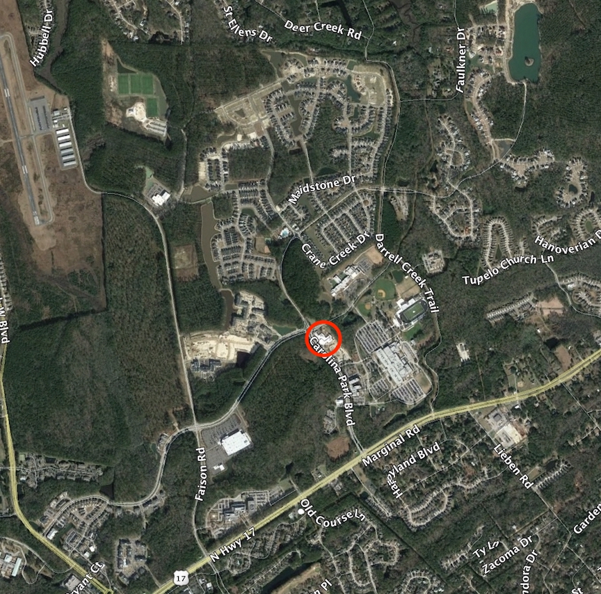
The new Wando Mount Pleasant Library is located at 1400 Carolina Park Boulevard in the town of Mount Pleasant. A visit to this neighborhood today involves a trek down the six-lane thoroughfare known as Highway 17 (U.S. Route 17), past a succession of brand-new commercial buildings and a host of brand-new amenities. The library itself is nestled in a large new residential development called Carolina Park, and is next-door to the fifteen-year-old Wando High School. If you’re new to the area, you might be tempted to think that all of these features were carved out of the virgin forest in the very recent past. In Charleston County, however, there’s no such thing as a piece of virgin forest. Every piece of ground in our community has been impacted by numerous episodes of human activity dating back many centuries. This is certainly true of the site of our new library, and recently I’ve been fielding question about the history of that specific site. In the next several minutes, I’ll try to give you a brief history of the ground now occupied by the Wando library and the surrounding neighborhood.
Beginning in the 1500s, the first European explorers who visited the area now known as the Lowcountry of South Carolina encountered more than a dozen small but distinct groups of indigenous people living along the coastal plain. The Wando people first appear in the historical record in the spring of 1670, when English colonists began settling at a place they called Albemarle Point on the west bank of what they called the Ashley River (now Charles Towne Landing State Park). To the north of that site lay a broad peninsula, bounded on the north by a river the Indians called the Wando. Those early settlers observed a small band of indigenous people calling themselves the Wando residing near the south side of the mouth of the river that now bears their name. That is to say, somewhere in the vicinity of what is now called Remley’s Point in Mount Pleasant, on the south side of the Wando River, north of Highway 17.[1]
It’s important to note that the first permanent English settlement in this area commenced in the spring of 1670, at which time the colonists found the local Indians residing along various rivers near the coastline. These locations were not their permanent residences, however, as the indigenous people in this area followed a traditional pattern of seasonal migrations. The Wando and the other tribes appear to have spent the spring and summer months living in semi-permanent camps near the sea coast, fishing and farming, and then moved farther inland during the autumn and winter months to hunt and to dress animal skins.[2]
Like the other indigenous people residing here in the 1670s, the population of the Wando people was relatively small. Early European settlers observed that each of these coastal tribes numbered less than fifty bowmen, representing around two hundred individuals. Due to the paucity of surviving early documents, and the cultural bias of the early settlers, we have very little information about the culture of the Wando and the other indigenous groups that once inhabited the Lowcountry of South Carolina. All that remains of them now are fragments of hand-made pottery that have been found in local archaeological sites. More than one hundred Native American place names survive in the South Carolina Lowcountry, like the word Wando, but we don’t even know what sort of language or languages these people once spoke.[3]
Immediately after arriving in 1670, the English settlers began claiming lands on which to establish homes and farms or plantations. These colonial intrusions displaced many of the indigenous peoples, with whom the white settlers attempted to maintain amicable relations. In 1675, the Wando people, along with the Etiwan, Sampa, and Sewee, asked the English settlers for a reservation of land that they could inhabit without further displacement. The provincial government allocated to these combined tribes a large tract of land on both sides of the Wando River, three miles beyond its mouth. Around 1675, therefore, the Wando moved a bit to the northeast, and perhaps continued to do so as more settlers moved into the area now generally called Mount Pleasant.[4]
In the Lowcountry, as in other parts of the New World, European settlers introduced a variety of diseases and abuses to the indigenous peoples that rapidly reduced their numbers. Although surviving documentary evidence of these diminishing populations is lamentably sparse, the Wando people appear to have ceased to exist as a distinct group within twenty-five years of the founding of South Carolina. A law ratified here in the spring of 1696 mentioned the names of eleven local Indian tribes who had agreed to help the settlers destroy what they called “beasts of prey.” That list does not mention the Wando people, however, whose numbers might have been so small in 1696 as to cease to constitute a distinct band or tribe.[5]
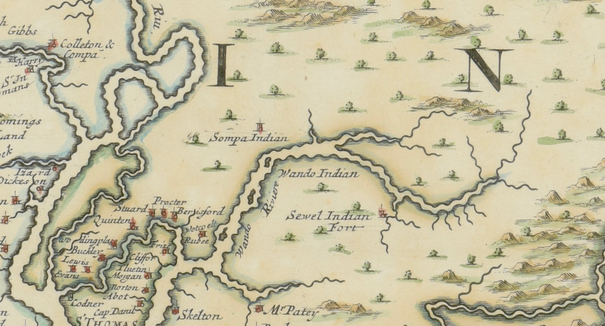
When the South Carolina legislature created a system of Anglican parishes throughout the colony in 1706 to serve as both the religious and political precincts, the land between the Wando River and the Atlantic Ocean, east of Charleston harbor and west of Awendaw Creek, became known as the parish of Christ Church. The principal church of Christ Church Parish still stands on the south side of Highway 17, opposite the east end of Long Point Road. I mention this fact to point out that the traditional territory of the Wando people became part of Christ Church Parish in 1706. Nine years later, in 1715, the minister of the new parish church, the Reverend Gilbert Jones wrote to his superiors in England about the make-up of his congregation. Without providing any specifics, Jones simply reported “I have no free Indians in my parish.”[6] Although the Wando people had apparently disappeared, their name continued to apply to the river-front land at the northeastern end of Christ Church parish, which became known as Wando Neck.
Highway 17 slices through the middle of the town of Mount Pleasant and constitutes a defining feature of the modern landscape, but it hasn’t always been there. In its earliest manifestation it was called “the George Town Road” because it connected travelers between the ferry landing on the east bank of the Cooper River (see Episode 67) and the new town of George Town, which was created in 1729. Because the South Carolina legislature first offered to pay a rider to carry mail overland from Charles Town to George Town in 1739 (see Episode 61), we can deduce that the path we now call Highway 17 was created sometime during the 1730s. Rest assured, however, that the original path was much narrower than the modern six-lane eyesore.
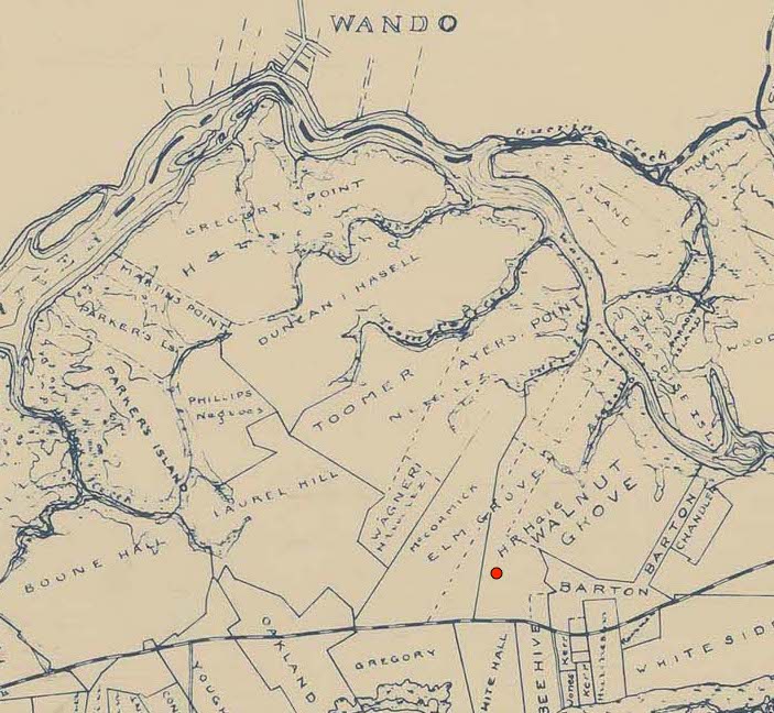
As the presence of the Wando people receded around the turn of the eighteenth century, the provincial government of South Carolina began dividing up their land and granting it to European settlers. From the early 1700s to the 1860s, the site of the new Wando Mount Pleasant Library was part of landscape dominated by plantation agriculture and inhabited principally by enslaved people of African descent. More specifically, the library site was once part of a plantation known as Elm Grove, which was eventually combined with a neighboring tract known as Walnut Grove. The modern Carolina Park development, in which the library is situated, contains parts of both of these plantations, which share a great deal of history.
An early settler named Roger Player received a grant for 500 acres in this area in 1704, followed by a grant of an additional 500 acres in 1706. These grants represent the beginnings of plantation agriculture at the site of the new Wando library, using enslaved African captives to work the land for the enrichment of the white owner. No records survive to document the first people of African descent to work at this site, but the timing of those early grants is significant. By 1708, just a few years after Roger Player received grants at this location, the number of enslaved Africans in South Carolina had exceeded the number of white Europeans. In subsequent years, the black population continued to grow at a faster rate than the white population, as more and more Africans were imported through the port of Charleston. Roger Player died around the year 1720, at which time the population of Christ Church Parish was reported to contain 637 enslaved people and 107 white taxpayers or heads of families. That is to say, the total population of Christ Church Parish in 1720 was about 1,200 people, the majority of whom were of African descent.[7] The parish, or greater-Mount-Pleasant-area, retained this black majority until the end of the twentieth century.
In the early eighteenth century, Roger Player assembled several land grants into a sizeable plantation that he devised to his sons, named Roger and Thomas. In 1729, they sold the property in question to Solomon Legare, one of the many French Protestant, or Huguenot, refugees who settled in the Carolina Lowcountry around the turn of the eighteenth century.[8] The Legare family retained this property for more than a hundred years, enlarging both the number of acres and the number of enslaved laborers working the land. By the early 1800s, the property that forms the new Carolina Park development was owned by two branches of the Legare family and operated as two distinct plantations. The western part became known as Elm Grove, while the northeastern part became Walnut Grove. Because the site of the new Wando Mount Pleasant Library is situated within the boundaries of Elm Grove plantation, I’ll focus on the history of that property.
More importantly, Daniel Legare held title to Elm Grove at the time of the 1850 Federal Census of the United States. In addition to counting free residents, both black and white, the 1850 Federal census also included a separate schedule of “Slave Inhabitants” and another schedule called “Productions of Agriculture.” Like the regular historic censuses, you can find all of these materials on microfilm at CCPL’s South Carolina History Room at the main library, in case you’d like to explore them yourself.
On August 7th, 1850, the census enumerator counted ninety-two enslaved people on Daniel Legare’s plantation in Christ Church Parish, including fifty women and girls, and forty-two men and boys. The census did not record the names of these people, unfortunately, but it recorded their respective ages, which ranged from four months to 80 years old.
According to the agricultural schedule of the 1850 census, Daniel Legare’s plantation in Christ Church Parish consisted of 300 acres of “improved” land and 1,000 acres of “unimproved” land, on which he kept a few horses and mules, about fifty head cattle, and forty-five hogs. During the preceding year, the plantation had produced 700 bushels of corn, 160 bushels of oats, and 24,000 bushels of rice, which appears to have been their principal crop.
By 1850, rice had been the principal crop for Wando River planters for more than a century, but the market had become so glutted with supply that the price of rice was in decline. In response, many planters in this area began turning to new endeavors, especially the large-scale harvesting of clay from the banks of the Wando River to produce bricks. Based on later evidence, it appears that the Legare plantation at Elm Grove and the plantation next-door, Walnut Grove, owned by George White, were both moving away from rice and into brick-making in the early 1850s.
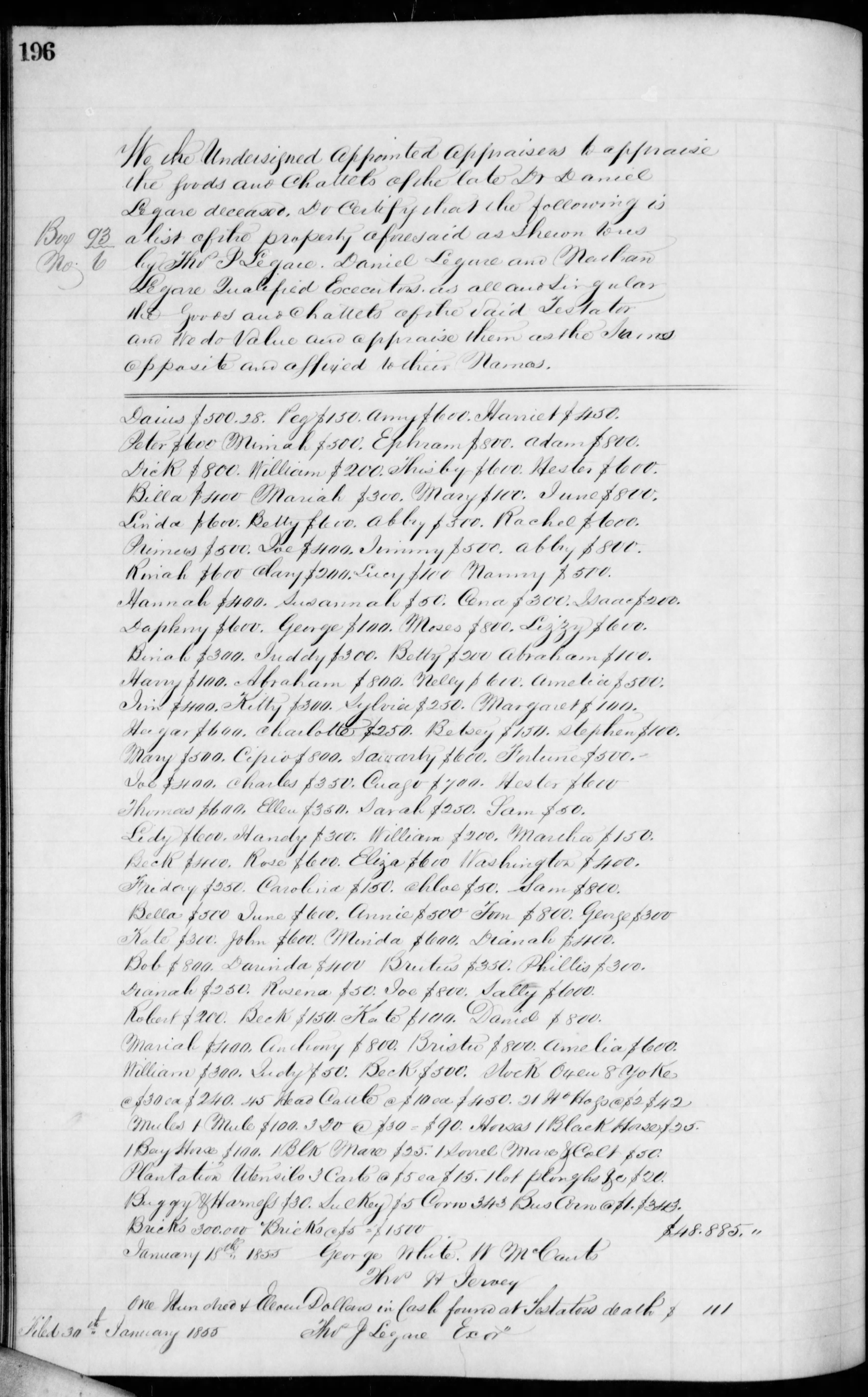
Following the death of Dr. Daniel Legare on December 29th, 1854, the executors of his estate immediately began to liquidate the plantation known as Elm Grove. On January 18th, 1855, a group of appraisers made a list containing the names of 104 people living and working on the plantation, and assigned a monetary value to each person. In addition, they counted and valued a small number of horses, mules, oxen, equipment, and a pile of 300,000 bricks. The appraisers estimated the total value of these people, animals, and objects to be $48,885. An advertisement placed in the local newspaper on February 9th announced the upcoming sale of these people, who were described as being “accustomed to the culture of rice, cotton and provisions.”

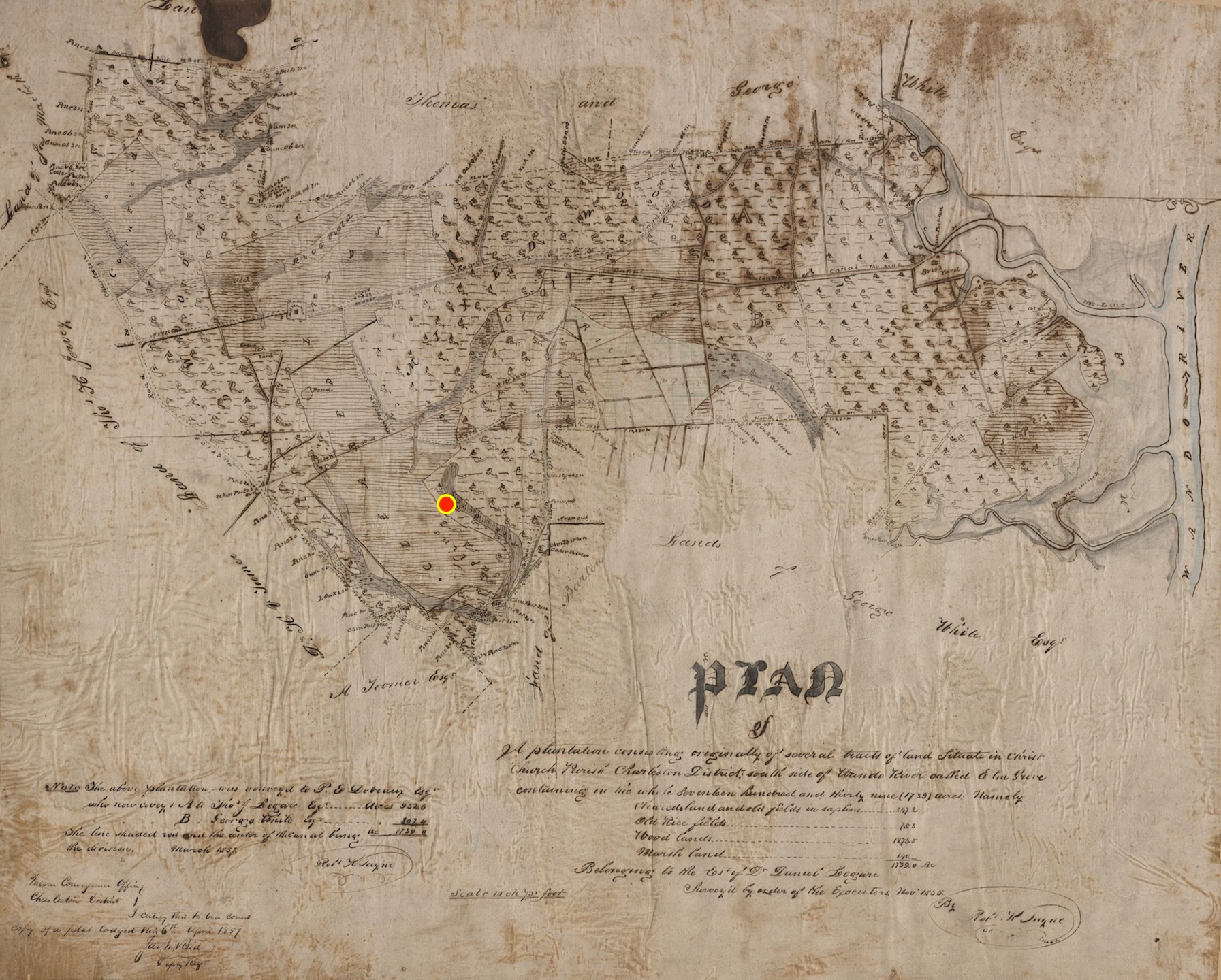
With the sale of Elm Grove’s labor force in early 1855, the plantation became dormant. Dr. Legare’s son, Thomas J. Legare, hired surveyor Robert Payne in 1855 to create a highly-detailed plat of the property in order to attract a buyer. That plat (which I’m including in the text version of this program on the library’s website) shows a diverse landscape encompassing 1,739 acres sandwiched between the Wando River on the north and the public road (Highway 17) on the south. The property contained seventy-five acres of “old rice fields,” nearly 250 acres of old fields planted with saplings, 140 acres of marshland, and 1,276 acres of woodlands. A man-made canal led from Darrell Creek to the south, carrying water to a complex of old rice fields. (That canal is still visible adjacent to the modern road called Recreation Way.) On the banks of the Wando River is a boat landing, a large “brick yard,” and a separate “brick kiln.” The main entrance to the plantation is a driveway that is now part of Faison Road. It led from the public highway to a “settlement” or big house with several outbuildings that stood near the modern intersection of Faison Road and Park Avenue Boulevard. A bit further up this driveway, north of the big house, appear eleven smaller structures, arranged in two rows on either side of the road, labeled with the word “Negro.” These were the modest dwellings of the plantation’s enslaved people. Near the big house is also a “grave yard,” which today is located on the east side of Faison Road, near Highway 17. The site of the new Wando Mount Pleasant Library, like that of its neighbor, Wando High School, appears to have been an old rice field planted with saplings in this 1855 plat.[11]
The people who lived and worked on George White’s combined plantation on the south side of the Wando River appear in the 1860 Federal census of “Slave Inhabitants” of Christ Church Parish. On June 26th of that year, the census enumerator counted ninety-one people at this site, including fifty-three men and boys, and thirty-eight women and girls. The census did not record their names, but it recorded their respective ages, which ranged from six months to eighty years old.
According to the 1860 schedule of “Productions of Agriculture” in Christ Church Parish, George White’s plantation included a variety of horses, mules, cattle, sheep, and hogs. The plantation included 500 acres of “improved” land and 2,176 acres of fallow “unimproved” land. During the previous year, the plantation had produced 700 bushels of corn, 200 bushels of oats, 20 ginned bales of cotton (400 pounds each), 200 pounds of wool, and a large quantity of sweet potatoes. That volume of agricultural produce does not necessarily reflect the large population of enslaved people residing on the property, however. It appears that brick-making might have been their principal occupation.[13]

According to the 1880 agricultural census, George White had 1,200 acres under cultivation, 200 acres of meadows (probably for pasture), and 1,000 acres of woodlands and forest. The family raised sheep, swine, and poultry, and grew corn and oats, but laborers were no longer actually living on site.
The White family sold this property in 1900 to Henry Rich Hale (1864–1943).[14] According to a number of newspaper advertisements and notices published in the early twentieth century, the Hale family sold poultry eggs, cotton seed, and grew vegetables to truck to local markets. They also hosted annual deer hunts for their friends and occasionally rented acreage to other small farmers. The Hale family sold the property in 1936, at which time the land that now forms Carolina Park entered a new and very different era.
Part of the plan for the Carolina Park development involved setting aside 100 acres for future public amenities. Wando High School opened in 2004, and the new branch of the Charleston County Public Library opened on June 10th, 2019. Both of these structures, as well as the surrounding new suburban residences, are planted in a landscape rich in history. Before European settlers first enchroached on this land 350 years ago, the Wando people enjoyed cool ocean breezes here during the warm months of the solar year. After their disappearance around the turn of the eighteenth century, the land was owned by a succession of white men who grew rich from the labors of generations of enslaved people of African descent. At the site of the new library, they grew rice, cotton, and other vegetables, and scooped clay from the Wando River to make bricks on a plantation once known as Elm Grove. Those people are all gone, but their descendants still form part of the neighborhood. The Charleston County Public Library invites you to visit the new Wando Mount Pleasant branch, and, as a historian, I invite you to remember this neighborhood’s colorful agrarian past as you traverse the modern suburban landscape.
[1] For a general summary of Wando history, see Gene Waddell, Indians of the South Carolina Lowcountry, 1762–1751 (Columbia, S.C.: Southern Studies Program, University of South Carolina, 1980), 329–32.
[2] Waddell, Indians, 3–6, 34–35.
[3] Waddell, Indians, 8–15, 23–33.
[4] Waddell, Indians, 4.
[5] See “An Act for Destroying Beasts of Prey, and for Appoynting [sic] Magistrates for the Hearing and Determining of all Causes and Controversies between White Man and Indian, and Indian and Indian,” ratified on 16 March 1695/6, in Thomas Cooper, ed., The Statutes at Large of South Carolina, volume 2 (Columbia, S.C.: A. S. Johnston, 1837), 108–10. The eleven tribes mentioned in this act include (in the original spelling) “Sante Helena, Causa, Wimbehe, Combehe, Edistoe, Stonoe, Kiaway, Itwan, Sewee, Santee, Cussoes.”
[6] Waddell, Indians, 332.
[7] Peter Wood, Black Majority: Negroes in Colonial South Carolina from 1670 through the Stono Rebellion (New York: W. W. Norton, 1974), 144-46, citing reports from the governor in 1708 and 1720 to the Board of Trade in England.
[8] Charleston County Register of Deeds, S: 204.
[9] Charleston County Register of Deeds, X13: 116.
[10] See Charleston County Estate Inventory Book D, 1854–57 (available on microfilm at CCPL’s South Carolina History Room), pages 196 (names and values of 104 people, animals, and equipment), 246–47 (purchasers of the people; steamboat and jail fees), and 326 (purchasers of the animals and articles). Advertisements for the sale of the people and the real estate first appeared in Charleston Courier, 9 February 1855, and continued until the day of sale.
[11] Robert K. Payne’s plat of Elm Grove Plantation, created in November 1855 and updated in March 1857, was recorded on 6 April 1857 in Charleston County Register of Deeds, Plat Book A, page 140. This item can be found on microfilm in CCPL’s South Carolina History Room. My thanks to Bob McIntyre for providing the wonderful digital scan of this historic plat. The office of the Charleston County Register of Deeds is an amazing public resource!
[12] See Charleston Courier, 19 December 1855. Thomas J. Legare conveyed or mortgaged part of Elm Grove to the Deveaux family on 27 November 1856, but this was a temporary action. He conveyed the entire property to George White on 2 April 1857. See Charleston County Register of Deeds, T13: 160 and U13: 264.
[13] Some historians have noted that J. Thomas H. White advertised to sell an extensive brick-making plantation called Elm Grove in 1863, but this advertisement is flawed. A few days after its initial publication, the name of the advertised plantation was changed to Laurel Hill. See Charleston Mercury, issues of 27 February and 4 March 1863, and Charleston Courier, issues of 28 February and 3 March 1863.
[14] Charleston County Register of Deeds, R23: 77.
[15] International Paper Realty Corporation to CDM Charleston LLC, 30 Dec. 1987: sale of Nichols-Maybank tracts A, B, and C (1,700 acres), Charleston County Register of Deeds, N171: 034.
PREVIOUS: Abraham the Unstoppable, Part 8
NEXT: Remembering the Battle of Sullivan’s Island
See more from Charleston Time Machine