Amidst another influx of French-speaking refugees in the spring of 1804, Charleston’s municipal authorities negotiated with property owners to resuscitate the Market Street plan scuttled more than a decade earlier. Charles Cotesworth Pinckney, the project’s principal donor, dictated new terms to city officials and set a three-year deadline, triggering a flurry of site work and legal negotiations that eventually secured the permanent establishment of the present historic marketplace.
The 1793 collapse of the Market Street plan, initiated in 1788, spawned a dozen years of costly but inadequate compromises. As I described in the previous episode, City Council funneled most of the community’s daily food sales to an array of new facilities at the east end of Queen Street, a less commodious waterfront site that functioned as the city’s principal public marketplace at the close of the eighteenth century. A short distance to the north, however, one facet of the abandoned 1788 plan survived and reached maturity. The plat annexed to the original deed for the creation of Market Street illustrates a proposed widening of East Bay Street, from Craven Bastion (now the site of the U.S. Custom House) northward to Ellery Street and beyond. Although the city had negotiated with local wharf owners in late 1787 to straighten and widen the southern part of East Bay Street to the uniform breadth of sixty-six feet, the roadway continued to the north of Craven Bastion at the modest width of just twenty-two feet.[1]

The root of this bottleneck was, and still is, East Bay Street’s constricted intersection with the former creek now called Market Street. A long, arching brick bridge erected at this site in 1767–68 replaced an earlier wooden structure and facilitated the passage of small boats along the waterway, but its narrow roadway, measuring nearly three hundred feet long by twenty-two feet “in the clear,” was not sufficient for the increasing volume of vehicular and pedestrian traffic at the end of the eighteenth century.[2] Governor’s Bridge, as it was known, had also settled unevenly shortly after its completion; a description published in 1770 noted that the western peak of the central archway was twenty-six inches lower than the eastern peak. City Council solicited bids in October 1793 “to repair the bridge on East Bay, commonly called the Governor’s Bridge,” but four months later revised the project’s scope, proposing instead “to build a new bridge nearly upon the same place where the present bridge now stands.”[3]
The 1794 plan to build a new bridge over Daniel’s Creek quietly disappeared as local officials diverted their attention and resources towards other pressing ventures. In addition to the stress of accommodating refugees from Saint-Domingue and preparing for possible war with Britain or France, City Council also lacked authority to annex a small parcel of required land at the northwest corner of East Bay and Ellery Streets belonging to the estate of Robert Raper, whose legal heir in England had been deemed mentally incompetent. All of these obstacles receded during an era of economic prosperity at the turn of the nineteenth century, inspiring City Council to advance the street-widening project in stages from south to north.
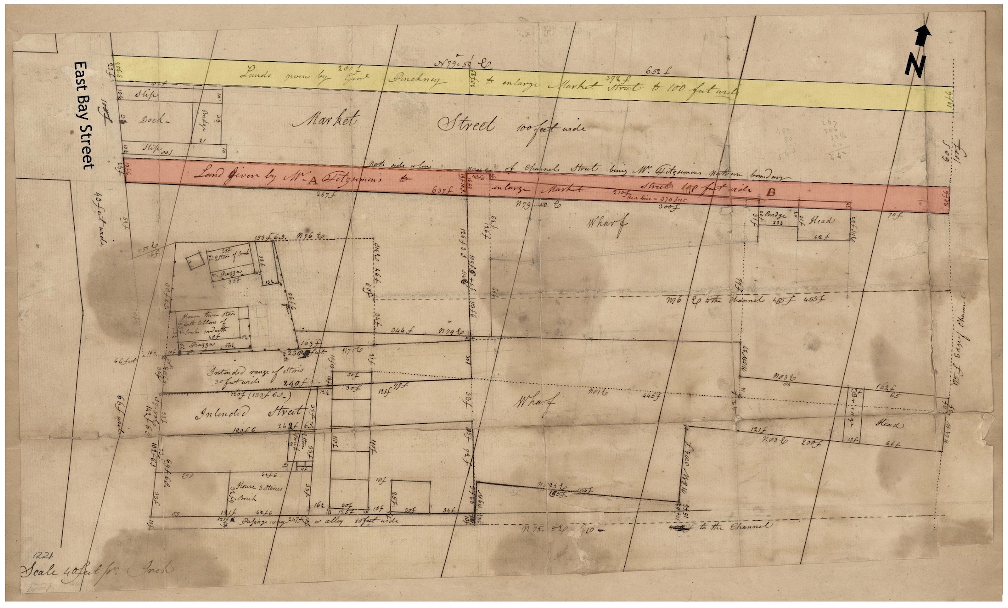
During the autumn of 1801, city officials negotiated with General Charles Cotesworth Pinckney and Christopher Fitzsimons, owners of the land touching Governor’s Bridge, who agreed to donate several adjacent slivers to facilitate the widening of East Bay Street from the site of Craven Bastion (demolished in late 1789) to Guignard Street at the breadth of forty-two feet.[4] Rather than construct a similar but wider bridge across the watery site, Council solicited bids from bricklayers in February 1802 to construct a pair of long masonry walls to enclose the old bridge and define the street’s new boundaries to the east and west.[5] The project included a central brick drain or culvert, but the opening was no longer intended for the passage of boats along the tidal creek. After building up the masonry revetment walls vertically from the creek bed to the desired street level, workers dismantled the old arching bridge and filled the void to create a level causeway. The completed roadbed resembled the modern intersection of East Bay and Market Streets, but its sandy surface, according to an 1804 survey, was eleven feet lower than that of Meeting Street, 1250 feet to the west.[6] The municipal project to widen East Bay Street continued northward from Ellery Street to Hasell Street during the subsequent months and years as the heirs of Robert Raper and other property owners on the west side of the thoroughfare sacrificed slivers of their frontage to accommodate the increasing flow of traffic.[7]

The improvements surrounding Governor’s Bridge also accelerated the development of valuable waterfront property immediately north of the constricted intersection. An explosion of cotton exports in the late 1790s, cultivated by South Carolina’s swelling population of enslaved laborers, fueled the construction of new wharves, streets, and buildings within the maritime landscape formerly known as Rhett’s Point and The Hard. Besides the growth of urban infrastructure, Charleston’s booming economy at the turn of the century nurtured an expanding cultural scene, enlivened most notably by French-speaking immigrants from the troubled island-colony of Saint-Domingue. Their contributions to local theater, music, dance, art, cuisine, education, and folklore endured for generations, unlike the spirit of the revolution that propelled them into exile.
The bloody French Revolution disintegrated in the late 1790s through a lack of political consensus, allowing the rise of an obscure young soldier named Napoleon Boneparte who claimed dictatorial powers at the dawn of the nineteenth century. Although the French Republic had abolished slavery throughout its realm in 1794, Bonaparte sought to reverse years of political progress and make France a great empire again. In 1802 he sent a large number of troops to war-torn Saint-Domingue with the explicit goal of re-enslaving the vast majority of its black population. Afro-Caribbean soldiers, facing a potential return to bondage, crushed the visiting French Army and forced the survivors to evacuate the island in late 1803. The independent state of Haiti, not yet a republic nor a monarchy, was formally proclaimed on 1 January 1804.
Shortly after declaring sovereignty, Haiti’s military leaders commenced a brutal, genocidal campaign to exterminate the island’s remaining European population. Many hundreds perished while thousands of white families, mixed-race people, and their enslaved servants escaped in merchant vessels bound for nearby islands and then to North America, just like the mass exodus from Cap-Français in 1793. Many of the French-speaking refugees who had settled in Charleston during the 1790s opened their homes and businesses to the latest immigrants. A “Committee of Benevolence” appointed by the city’s French community in early 1804 began collecting donations and distributing aid to the new refugees. The St. Cecilia Society, then the premier musical organization in the United States, hosted a series of charity concerts featuring French performers to raise large sums of money. In March, both groups partnered with City Council to distribute essential supplies to the distressed immigrants.[8]

Perhaps there was talk in Charleston during the early spring of 1804 of housing some of the latest refugees in the makeshift dormitory fronting Meeting Street, a neglected site used for the same purpose a decade earlier. The municipal government had opened the 200-foot long structure in 1789 as a public market built on donated land, but its conversion into a refugee warehouse in 1793 “rendered imaginary” the city’s claim to the property formerly called Market Street. The fifteen-year-old market shed was in disrepair in 1804, however, and might have still sheltered some unknown number of immigrants. If city officials had any notion of using the former marketplace to accommodate a new wave of refugees, they would have to negotiate with the site’s legal owner, Charles Cotesworth Pinckney. Accordingly, in early April, City Council appointed a committee “to confer with Genl. Pinckney respecting the Market on his land, near Meeting Street.”
The fifty-eight-year-old veteran and former United States Minister to France likely received members of the municipal government at his elegant mansion standing at the southwest corner of East Bay and Guignard Streets. Pinckney declared his support for the prospect of the city doing something with the former market shed, either removing the long brick structure and several “temporary buildings” from his land or refurbishing the site for use as a public marketplace, as originally intended sixteen years earlier. In no uncertain terms, however, Pinckney rejected the idea of its continued use as a domicile for anyone. We can only imagine whether his opinion stemmed from the experience of living in close proximity to the site in question, or whether he harbored some resentment against the French officials who had insulted him in Paris seven years earlier during the XYZ Affair.
The committee appointed to confer with the general, “respecting the Market on his land,” made a presentation to City Council on 24 April 1804. Their report first summarized the “deed of cession and conveyance,” executed in late March 1788, and the terms surrounding the genesis of Market Street. In one long sentence, the committee summarized the rise and fall of that public marketplace more than a decade earlier: “That in consequence of the said deed . . . City Council erected and established at a very great expence, on part of the land conditionally ceded by General Pinckney as aforesaid, a spacious and convenient market of two hundred feet in length, which has become forfeited to the proprietor of the land, by reason of the failure of the City Council to comply with their contract, in making and filling up the street aforesaid.” “Notwithstanding the said forfeiture,” Pinckney had “declared his willingness . . . to permit the City Council to remove the buildings erected on his land, should they abandon the intention of continuing a market there, or to enter into a new contract with them, should they be desirous of establishing the said market.”

Members of the municipal committee then negotiated with Pinckney to settle the terms of a new contract. The general outlined a number of conditions for the re-establishment of Market Street, proceeding geographically from west to east. First, he set a deadline of twelve months for City Council to “cause the market already erected on the land of General Pinckney,” between Meeting Street and Maiden Lane, “to be repaired and put in good order, and established as a market.” Then the general pointed to that part of his property between Maiden Lane and the Governor’s Bridge, the center line of which had existed as a public right-of-way called “Canal Street” or “Channel Street” since Pinckney’s father commenced the subdivision of Colleton Square in the late 1730s. Here the general demanded that the city construct, within twelve months’ time,
“a good, substantial, brick drain, from Maiden Lane to the Governor’s Bridge, (which will be about nine hundred feet in length,) and to pile in the sides of the street the same distance, and forty feet wide, (the present width of the street to which the City Council is entitled, from the bridge to Church Street,) with palmetto logs or pine, or otherwise sufficiently secure the same within the time aforesaid; and fill up the said street of 40 feet wide, to a proper level, with wood, and with rubbish to be collected by the City Scavenger, or with other materials, either within the said time, or to complete the same with all convenient speed thereafter.”
Because Pinckney was the principal, but not sole owner of the property in question between Church Street and Governor’s Bridge, he challenged City Council, “as soon as possible, to procure, either by cession, purchase or application to the legislature, so much of the land between Church Street and the Bay, belonging to other persons . . . as will make the said intended [Market] street, one hundred feet wide.” If the city succeeded in acquiring the necessary property, Pinckney required Council to “fill up the remaining width of the said street, with all convenient speed.” If, however, the city did not acquire the land necessary to widen the existing Canal Street to the breadth of one hundred feet within three years’ time, the general declared bluntly that his proposed contribution, “so far as shall relate to any lands, between the Bay and Church Street, shall be void.”
Finally, Pinckney addressed the proposed widening of the canal extending from Governor’s Bridge eastward to the Cooper River, where his father had ceded a sixty-foot wide channel to the public “about the year 1740.” Here the general offered to sacrifice a twenty-foot-wide strip of his own waterfront property on the north side of the canal, on condition that his neighbor to the south, Christopher Fitzsimons, would cede a matching strip to facilitate the eastward continuation of Market Street at the uniform breadth of one hundred feet.
Before concluding their report to City Council, the negotiating team offered a frank appraisal of the underlying issue: “Your committee beg leave to observe to Council, that they know of no place in the city, which can possibly be procured, so well adapted, as the one now offered, for a Public Market, not only on account of its central situation, but of its extent, being 100 feet in width . . . and 1775 feet (upwards of 1/3 of a mile) in length from Meeting Street to the channel of the river.” After “due consideration of the premises,” the committee advised Council to embrace the conditions proposed by General Pinckney to re-establish Market Street. To fund the significant site work necessary to meet his terms, the committee suggested Council draw from the large sum of $20,000 raised by the sale of the old Beef Market lot at the corner of Meeting and Broad Streets in June 1800,[9] “or so much thereof as may be necessary . . . towards defraying the expence of repairing the Market, and making the drain, and piling in and filling up the street.” The city aldermen voted to accept the committee report of April 24th and immediately nominated two new committees, one to negotiate with General Pinckney and other parties to acquire “so much of the land necessary for the purposes in the foregoing report mentioned,” and another to “superintend the building of the drain and piling and filling in the street . . . from Maiden Lane to the Governor’s Bridge.”[10]

Days later, in early May 1804, the men appointed to superintend the site work in Market Street engaged surveyor and former alderman Joseph Purcell to create a detailed new plan of the landscape in question.[11] They also contracted with local builders John and Henry Horlbeck, who supervised a team of enslaved laborers, to commence a longitudinal drain through the center of the creek bed, extending that created in 1788, near Meeting Street, eastward from Maiden Lane to Governor’s Bridge.[12] While that work progressed in June, the committee advertised for the delivery of large quantities of “pine wood” required for “the filling up of Market-street.”[13] This laborious engineering work, which continued for several subsequent years, gradually obliterated the tidal inlet once called Daniel’s Creek.
After witnessing four months of progress in the creek bed during the summer of 1804, City Council reconvened on August 28th to hear an important report from the committee appointed to secure the property cessions necessary to re-establish Market Street. The team informed council that General Pinckney had affixed his signature to a more succinct set of terms inscribed “on a certified copy of the report of the Committee of Council agreed to on the 24th day of April last.” The engrossed manuscript in question is now lost, but an official copy made by the Clerk of Council in 1805 surfaced in 2014 among the papers of a Pinckney descendant, now archived by the South Carolina Historical Society.[14] Because this long-forgotten agreement has determined the legal status of Market Street from 1804 to the present time, its text merits public notice. According to the report adopted by City Council on 28 August 1804, General Pinckney and his neighbors agreed to the following terms:
“That the buildings erected, or to be erected, in the ceded street [be used] as a Market or Markets, and applied to no other purpose; and on no account, after the first day of December next [i.e., 1 December 1804], be made the residence or habitation of any person or persons; but that the Market, from that time be laid open, and continued so, under the penalty of reverting to the grantors, respectively, and their heirs, in their former rights and estate;
That the City Council do cause the sides of the [Market] street from the [Governor’s] Bridge to Church Street to be filled in to the width of one hundred feet with palmetto logs or pine, or otherwise sufficiently secured, and cause the same to be filled up, to a proper level, with wood or rubbish, within the time mentioned in the report [i.e., within three years’ time];
That the twenty feet to be ceded [by General Pinckney,] in breadth, to the eastward of the Governor’s Bridge, is on condition that the City Council obtain, within a reasonable time, a similar cession or title to twenty feet, from the proprietor or proprietors of the lands on the south of the street so as to make the street to the eastward of the bridge one hundred feet wide, as contemplated in the former cession, otherwise to revert to the former proprietor and his heirs;
That the taxes assessed upon the said lands, from the former cession [in 1788] to the present time, on account of fronting on the said [Market] street[,] which was rendered imaginary, by their not being improved according to agreement, be so far refunded as to go towards the payment of the taxes of any other lands in the city, possessed by the grantors respectively.”[15]

After voting to adopt the terms settled with General Pinckney, City Council authorized the market commissioners “to remove the fences, erections, and temporary buildings around and within” the western end of Market Street and to prepare an estimate of the work required to restore the fifteen-year-old shed to its original purpose. Details of that repair work do not survive, but in December 1804, the city clerk assigned to the project solicited bids to rebuild the eaves of the roof, “to extend all round the market, seven feet from the outside wall,” like those of the market erected in Queen Street five years earlier. The roofline of the older structure in Market Street was complicated by its curious design, which included a pair of symmetrical wings extending to the east and west of a central block. Carpenters erected rows of wooden stalls along the interior of the western wing in February 1805, and on March 12th a city clerk announced that “the west end of the market in Market-street is now opened for the disposal of all kinds of butcher’s meat, poultry, venison, butter, vegetables, and country provisions brought in waggons.”[16]
In the span of sixteen months following the April 1804 conference with General Pinckney, Charleston’s municipal government spent more than $18,500 “to defray the expense of building a drain and making the new street called Market Street.”[17] The project was sufficiently advanced by the late summer of 1805 to inspire a formal announcement of the site’s legal rebirth. In an ordinance drafted by Intendant Thomas Winstanley and ratified by Council on August 22nd, the city acknowledged both the “forfeiture” of the Market Street plan initiated in 1788 and the recent renegotiation of the same property. Council then declared Market Street, from Meeting Street to the channel of the Cooper River, to be a public marketplace subject to the rules and regulations ratified by City Council and enforced by the Commissioners of the Markets, “in which, on every day in the week, at such hours and times as are or may be usual in the other markets of the city, all kinds of butcher’s meat, poultry, fish, fruit, vegetables, and all other articles of provisions whatsoever, shall and may be sold.”
The reactivated landscape of Market Street offered few amenities to the public in the late summer of 1805, but the site’s recently-improved topography enabled the city to relieve the persistent congestion surrounding the smaller marketplace in Queen Street. The ordinance of August 22nd acknowledged that the “great increase of late years, in the number of waggons and carts from the country bringing poultry and fruit to market for sale” created a “want of sufficient room contiguous to the market, at the east end of Queen Street.” Local residents and merchants complained that “the passage through East Bay street is frequently so much impeded as to become dangerous, and is sometimes rendered almost impassable.” Starting on 1 September 1805, however, City Council ordained that the Commissioners of the Markets or their clerk shall direct all persons intending to sell country produce out of their carts and wagons “to the market in Market Street, and to no other place . . . drawn up and arranged in the said street, or near thereto, in such manner as the commissioners shall think most convenient for the sale of their poultry, fruit, and other articles which they may have.” Some of the country vehicles might have parked in the open space between Meeting Street and the first market shed, as intended in 1788, but the majority probably occupied the newly-filled terrain between Anson and Church Streets, which remained the city’s principal vegetable depot into the twentieth century. The parking clause of 1805 did not apply to ambulatory hucksters, however, described at that time as persons carrying “poultry, fruit, or other articles through the city for sale, after nine o’clock in the morning, they keeping no fixed stand, but moving from place to place, as the wants of the citizens or convenience may dictate.”[18]

By the autumn of 1805, therefore, Charleston’s municipal government had shifted a portion of the city’s daily food sales from Queen Street to Market Street, despite the fact that Council had not yet satisfied the terms dictated by Charles Cotesworth Pinckney. The written agreement adopted by City Council in late August 1804 included the signatures of both the general and his neighbor, Thomas Jones, but a further three and a half years passed before the city acquired the remaining property cessions.[19] To widen Market Street to the breadth of 100 feet between Governor’s Bridge and the Cooper River, Christopher Fitzsimons and General Pinckney each ceded a twenty-foot-wide strip of marshland from their respective lots in August 1806.[20] In January 1807, the city paid the Villaneuve family for a small parcel of land at the northeast corner of Market and Anson Streets, formerly the property of Sims White.[21] The final components required to cement the legal existence of Market Street included two small parcels of land at the south end of Raper’s Alley, owned by the legally-disabled heir of Robert Raper. After City Council twice petitioned the South Carolina General Assembly for assistance, an act of the state legislature in December 1807 empowered the city to seize the land in question and issue compensation to the distant heir. For reasons unknown, however, no record survives of the city acquiring any property or signatures from Mary Lingard (died 1812) or the heirs of John Wyatt (died 1797), who jointly held all of the land on the south side of Market Street, between Church and State Streets, and who participated in the original agreement settled in 1788.[22]
Step by step during the early years of the nineteenth century, City Council progressed towards the goal of securing the permanent restoration of Market Street. The widening of Governor’s Bridge in 1802, the drainage and fill work commenced in 1804, the carpentry repairs of early 1805, the ratification of a new market ordinance that August, and the subsequent acquisition of peripheral properties all contributed to the completion of an important municipal project. By the spring of 1807, however, the three-year timeline prescribed by General Pinckney in 1804 had nearly expired. In the next episode, we’ll follow the city government’s rush to lay the foundations for future structures in Market Street, and commemorate the debut of a new name for Charleston’s most commodious public mall.
[1]Wharf Owners to the City of Charleston, lease and release and plat, 19–20 November 1787, CCRD A8: 1–4.
[2]Act No. 954, “An Act for impowering the Commissioners of the Streets in Charlestown, to lay out and continue old Church-street [Meeting Street] to George-street, in Ansonborough; and for building a Bridge and Causey at the North end of the Bay of Charlestown,” ratified on 18 April 1767, in David J. McCord, ed., The Statutes at Large of South Carolina, volume 7 (Columbia, S.C.: A. S. Johnson, 1840), 85–87; South Carolina Gazette, 5 May 1767, page 3; South Carolina Gazette, 5–12 October 1767, page 3.
[3] See Robert Raper’s advertisement in South Carolina Gazette, 2 August 1770, page 1; and the municipal notices concerning the bridge in Charleston City Gazette, 22 October 1793, page 3; City Gazette, 21 February 1794, page 2.
[4] Charles Cotesworth Pinckney and Christopher Fitzsimons to City Council of Charleston, deeds of cession and conveyances in fee and plat, 2 November 1801, Charleston County Register of Deeds (hereafter CCRD), volume F7: 163–66.
[5] Charleston Times, 6 February 1802, page 3; The city’s annual accounts covering the period from 1 September 1801 to 31 August 1802 include a charge of $5,135.96 for “Governor’s Bridge—paid for stone work, materials, &ca. for rebuilding the same,” and in the subsequent fiscal year of 1802–3 a further expense of $1,050.98 for “bricklayer’s work, materials, &c.” at Governor’s Bridge; see Times, 1 September 1802; Times, 1 September 1803.
[6] Joseph Purcell’s May 1804 survey of Market Street, now plat #78 in the John McCrady Plat Collection, held by the Charleston County Register of Deeds, includes a profile or section of the site with horizontal measurements at various intervals, concluding that “the whole fall between Meeting Street and East Bay Street is 11 feet.”
[7] City Council of Charleston, petition to the South Carolina House of Representatives and Senate, 18 November 1801, South Carolina Department of Archives and History (hereafter SCDAH), Petitions to the General Assembly, 1801, No. 24 and No. 25; “An Act to Appoint commissioners to assess such parts of a lot a land in Charleston, as are necessary to widen East Bay Street, and to permit the City Council to enjoy the same as a public street, on the payment of the sum assessed as its value,” ratified on 19 December 1801, in McCord, Statutes at Large, 7: 116–17; City of Charleston to the estate Robert Raper, award, 11 August 1802, CCRD Q7: 349; John Dawson to City Council, release, 22 November 1806, CCRD S7: 442; Robert D. Lawrence to City Council, release, 22 November 1806, CCRD S7: 442; Eight proprietors of land on the west side of East Bay Street, between Pinckney and Hasell Streets, to City Council, 31 July 1807, CCRD U7: 336–38. Note that the City Council executed a similar series of acquisitions on the west side of East Bay Street in the late 1860s.
[8]City Gazette, 27 February 1804, page 3, “City Council”; City Gazette, 10 March 1804, page 3: “At a meeting of the Managers of the late charitable Concert and Ball”; City Gazette, 31 March 1804, page 3: “City Council”; Nicholas Michael Butler, Votaries of Apollo: The St. Cecilia Society and Concert Patronage in Charleston, South Carolina, 1766–1820 (Columbia: University of South Carolina Press, 2007), 187–95.
[9] City Council of Charleston to the President, Directors, and Company of the Bank of the United States, release in fee and plat, 19 June 1800, CCRD B7: 317–20.
[10]“Report of the City Council and Agreement relative to the cession of Market Street, 24 April 1804,” in “Pinckney family papers, 1765–1915,” collection #495, folder 14 (oversized), South Carolina Historical Society. Note that this report does not mention the conditional nature of Pinckney’s proposed cession of a twenty-foot-wide strip of land on the north side of the canal between Governor’s Bridge and the Cooper River. Pinckney addressed this omission in a letter to Charleston Intendant Thomas Winstanley on 3 September 1805, after which Winstanley discussed with Christopher Fitzsimons the cession of a twenty-foot wide strip of his land, and informed Pinckney the same day that he had “no doubt but that the city will procure it, on terms satisfactory to both parties.” See Charles Cotesworth Pinckney to Thomas Winstanley, 3 September 1805, in “Pinckney family papers, 1765–1915,” collection #495, folder 15; and Winstanley to Pinckney, 3 September 1805, in “Pinckney-Means family papers, 1701–1983,” collection #208.04 (P), both held by the South Carolina Historical Society.
[11] McCrady Plat #78, dated May 1804, is unsigned, but is clearly the handwriting of surveyor Joseph Purcell; compare it to a contemporary manuscript copy of the plat signed by Purcell, held by the South Carolina Historical Society, item #32-46-01.
[12] In the annual city accounts covering the period 1 September 1803 to 31 August 1804, the city paid John and Henry Horlbeck $2,871.76 “for building the new drain from the Governor’s Bridge to the end of Maiden Lane” and “for pine wood to fill up the said street” (see Charleston Times, 1 September 1804). In the annual accounts covering the same months in 1804–5, the city paid the same firm “the balance of their account, for building a new drain through the same,” $2,052.16 (see Charleston Courier, 31 August 1805, page 2). For information about the Horlbeck firm’s use of enslaved labor, see the “Horlbeck Brothers Records, 1824–1860,” collection #179 at the South Carolina Historical Society.
[13] City Gazette, 19 June 1804, page 3.
[14]Robert Behre, “Charleston Market survey comes home,” Post and Courier, 10 March 2014, Metro section, page 2.
[15] The text of the committee report of 28 August 1804, including the terms signed by General Pinckney, appears after the abovementioned report of 24 April 1804, in “Pinckney family papers, 1765–1915,” collection #495, folder 14 (oversized), South Carolina Historical Society. Clerk of Council Gabriel Manigault Bounetheau (1779–1818) produced an attested copy of these 1804 texts in consequence of the abovementioned correspondence between General Pinckney and Thomas Winstanley on 3 September 1805.
[16] See the public notices in Courier, 14 December 1804, page 3; Courier, 28 February 1805, page 3; Courier, 12 March 1805, page 3. In this quotation and others throughout this essay, I have reproduced the spelling used in the original source.
[17] See Schedule C in the annual report of city accounts, in Courier, 31 August 1805, page 2.
[18] “An ordinance confirming the establishment of a Public Market or Markets, in Market-Street in the City of Charleston, and for other purposes therein mentioned,” ratified on 22 August 1805, in Alexander Edwards, comp., Ordinances of the City Council of Charleston, Passed between the 24th of September 1804, and the 1st Day of September 1807 (Charleston, S.C.: W. P. Young, 1807), 300–4. The full text of this ordinance also appears in Courier, 24 August 1805, page 2. Winstanley took credit for drafting this ordinance in his above-mentioned letter of 3 September 1805 to General Pinckney.
[19] See the extract from the City Council proceedings of 28 August 1804, appended to the above-mentioned report of 24 April 1804, in “Pinckney family papers, 1765–1915,” collection #495, folder 14 (oversized), South Carolina Historical Society.
[20] Christopher Fitzsimmons to City Council of Charleston, release and plat, 27 August 1806, CCRD U7: 71–72; Charles Cotesworth Pinckney to City Council of Charleston, release and plat, 27 August 1806, CCRD U7: 72;
[21]James Miller, trustee for Susannah Peigne Villaneuve, wife of Jean Baptiste Villaneuve, of the first part; the said Susannah of the second part, and the City Council of Charleston, of the third part, “release of a piece of land to widen Market Street,” 16 January 1807, CCRD S7: 479–80.
[22] City Council of Charleston, petitions to the South Carolina House of Representatives and Senate, 25 November 1805 and 6 December 1806, in SCDAH, Petitions to the General Assembly, 1805, No. 71, No. 72; 1806, No. 22 and No. 23; City Gazette, 24 December 1806, page 2, “House of Representatives”; Act No. 1894, “An Act to Appoint commissioners to Assess such Parts of Lots of Land in Charleston, as a necessary to widen Market Street; and to permit the City Council to enjoy the same as a public street, on payment of the sum assess as its value,” ratified on 19 December 1807, in McCord, Statutes at Large, 7: 123–24; William Raper to City Council, Commissioners’ award & Plat,” 26 August 1808, CCRD Y7: 93–94.
NEXT: Charleston's Centre Market, Established 1807
PREVIOUSLY: Meandering Marketplaces in Urban Charleston, 1794–1805
See more from Charleston Time Machine