
If you’ve ever walked along the east side of Charleston’s East Bay Street, you’ve stood atop a forgotten brick wall that once defined the city’s waterfront. Construction of this half-mile-long “wharf wall” or “curtain line” commenced in the 1690s to separate the street from the harbor, and it formed a significant part of the town’s military defenses through the American Revolution. Knocked down to street level in the 1780s, the wall’s lower half survives just below the modern streetscape, but its precise location is now something of a mystery.
The waterfront curtain wall was once a prominent feature of Charleston’s built environment that would have been familiar to every inhabitant and visitor from the 1690s through the 1780s. Despite its long-standing position within the community, few historians have included this structure in their studies of the city’s evolving landscape. This neglect is not the result of bias or a lack of interest, but rather the result of a convoluted paper trail. The long but incomplete story of the construction, maintenance, and demolition of the curtain wall is inscribed within the extant manuscript records of South Carolina’s early government, which few modern readers have the opportunity or patience to peruse. After several years of combing through the surviving records at the South Carolina Department of Archives and History in Columbia, I’ve accumulated a significant amount of information related to the rise and fall of the curtain wall. The resulting mass of data forms a long and tangled narrative that doesn’t make for exciting reading, however. In order to promote a better understanding of the subject, I’ve assembled an overview organized by a series of questions focusing on the most salient points of its history.
What is the curtain wall?
The object in question is a linear structure that follows a roughly north-south axis along the east side of East Bay Street in urban Charleston. The name “curtain wall” is a modern mash-up of earlier terms. The earliest records of its existence describe the feature as a “wharf wall” because it was associated with the creation of the linear “wharf” along Charleston’s Cooper River waterfront that became East Bay Street (see Episode No. 180). In the early years of the eighteenth century, locals frequently called it the “front wall” because it served as the easternmost part of a growing network of defensive fortifications surrounding the town. Starting in 1720, locals began describing this front wall using the standard military term “curtain line”; that is, a linear feature forming a defensive link between a series of gun batteries.
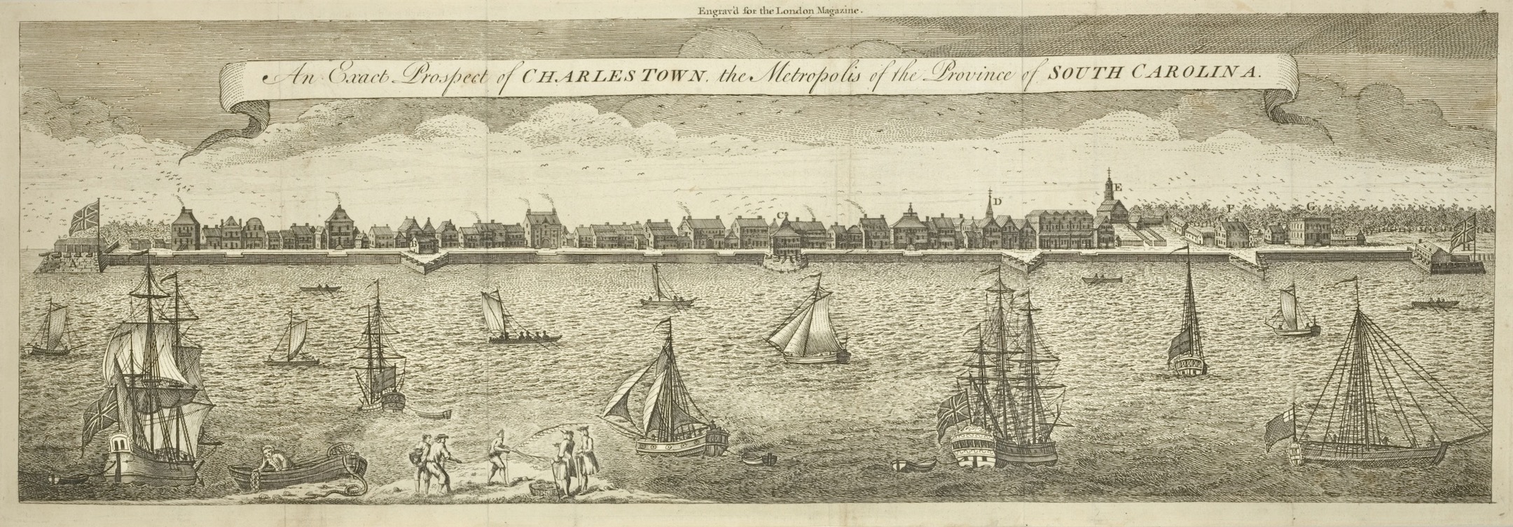
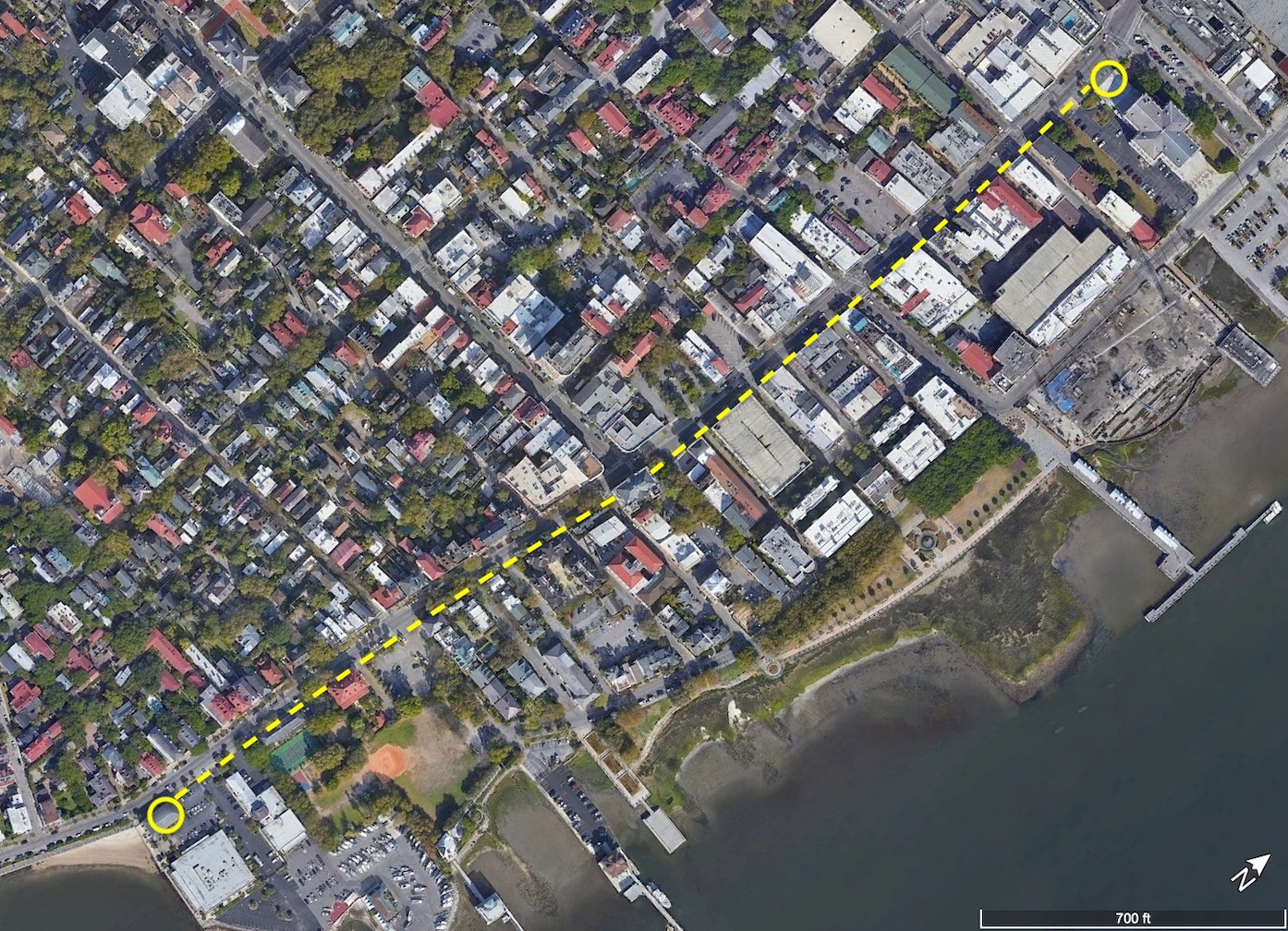
Even if you’re not familiar with the name, you’ve probably seen an image of the curtain wall. The most famous visual depiction is an engraving titled An Exact Prospect of Charles Town, first published in London in 1739 and then reprinted (in a slightly simplified form) in 1762. At the far left edge of that image is Granville Bastion, a diamond-shaped brick fortification with a large flag staff flying a British ensign. The remnants of that bastion are now under the Missroon House at 40 East Bay Street. The brick curtain wall extends northwardly from Granville Bastion to the east end of Tradd Street, where a V-shaped structure called a “redan” projects into the Cooper River. From the north side of the redan, the curtain wall continues northward until it intersects with the Half Moon Battery at the east end of Broad Street. From the north side of the Half-Moon, the curtain line extends to a second redan near the east end of Unity Alley, and then northward to a third redan near the east end of Lodge Alley. The waterfront wall terminates at a junction with Craven Bastion, another large, diamond-shaped structure now under the steps of the U.S. Custom House at 200 East Bay Street.
.jpg)
It’s important to note, however, that this image, which appears in numerous books about early Charleston, includes a measure of artistic license. The artist purposefully omitted the several large wooden wharves that extended from East Bay Street into the Cooper River at that time. Visitors to colonial-era Charleston arriving by sea would have seen only segments of the curtain wall between the long wharves. The artist Bishop Roberts might have omitted the wharves from his illustration to emphasize the strength and beauty of Charleston’s waterfront architecture, or perhaps he was simply unable to execute the proper foreshortening of the wharves in perspective.
What was the purpose of the curtain wall?
The structure served two important purposes. Initially, it was conceived and built as a revetment—that is, a continuous wall designed to reinforce the eastern line of Charleston’s first wharf, which we now call East Bay Street. The town’s original Cooper River waterfront was a low, sloping gradient like you see along riverbanks throughout the Lowcountry of South Carolina. Early civic leaders staked a line in the mud, roughly following the river’s high-water mark, and began building up the sandy shore behind the line. The creation of the wharf wall was the first step in creating a broad, level plain along the town’s waterfront that we see today. Its construction allowed Charlestonians to raise the level of the earth behind the wall to keep maritime commerce high and dry. This effort was an engineering first in early South Carolina, but it followed the model of similar revetment walls in other riverfront towns like London, Paris, New York, Boston, Philadelphia, Bridgetown, and many more.
Secondarily, at the turn of the eighteenth century, South Carolina’s provincial government began to regard Charleston’s brick wharf wall as a component in the town’s expanding network of urban fortifications. The creation of six gun batteries arrayed along the length of the Cooper River waterfront in the early 1700s divided the continuous wharf wall into a segmented curtain line composed of five distinct sections. The militarization of the wharf wall also transformed its design. To protect musketeers and cannon mounted on low ship carriages along East Bay Street, civic leaders increased the height of the original wall. The resulting structure served as both a waterfront revetment and a defensive curtain for the town’s defenders in case of enemy invasion.
When was the curtain wall built?
As I described in previous programs (see Episode No. 180 and No. 181 and No. 210), the groundwork for Charleston’s curtain wall commenced in 1694, and the majority of the early construction was done between 1696 and 1700. The arrival of a destructive hurricane in September 1700 caused catastrophic damage to the town’s waterfront and completely undermined the northern half of the curtain wall, above Broad Street. Repair work commenced in 1702, contemporary with the proclamation of a new war between Britain, France, and Spain that inspired South Carolina’s provincial government to turn its attention westward. Between late 1703 and early 1705, workers constructed a series of earthen entrenchments around the small compass of urban Charleston (see Episode No. 221 and No. 230).
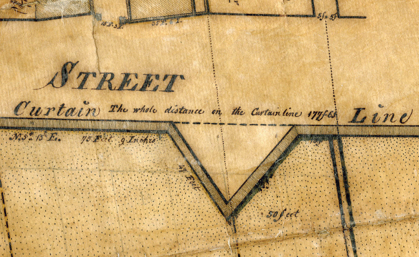
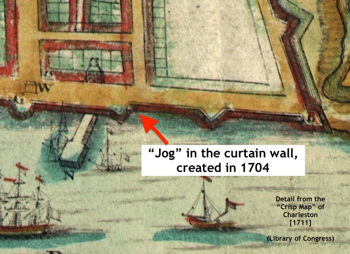
In November 1704, the legislature ratified a law that altered the trajectory of the northern half of the waterfront wall. The previous efforts to build the wall in a straight line from the Half Moon Battery to Daniel’s Creek (now Market Street) had failed because the line was drawn too far to the east, and the violence of the hurricane and subsequent storms had “utterly ruined” that part of the structure. Henceforth, said the law, the northward path of the wall should stop near the east end of Unity Alley and travel twenty five-feet inland before resuming its northward path toward Daniels’s Creek.[1] The resulting diagonal jog in the curtain wall is clearly visible in the map published in London in 1711 and commonly called the “Crisp Map” of Charleston.
The curtain wall was described as incomplete in the summer of 1707, when an act of the provincial legislature ordered it be “finished with all expedition,” but the date of its official completion does not survive among the extant legislative records.[2] Regardless of its physical state, the wall was battered by a pair of destructive hurricanes in 1713 and 1714. In the aftermath of the first storm, Governor Charles Craven stated that “the front wall, which is the bulwark & protection of the town, [is] utterly defaced and leveled with the water.”[3]
The General Assembly ratified an act in December 1714 to rebuild the curtain wall along a slightly revised design, but the eruption of the bloody Yemasee Indian War in April 1715 largely derailed that effort.[4] Another act, ratified in early 1720, ordered significant and immediate repairs to the curtain wall, but the success of that campaign is unclear.[5] A powerful hurricane in 1724 motivated the South Carolina legislature to enact another law in 1725 that transferred materials from the western walls of urban Charleston to shore up the failing curtain wall.[6] The political dysfunction that paralyzed South Carolina’s provincial government from early 1727 to the end of 1730 probably ensured that little of the work ordered in 1725 was actually done.
Following two more destructive hurricanes in 1728 and 1730, and the establishment of a more stable and authoritative royal government in 1731, the provincial legislature eventually turned its attention to the failing curtain wall. Fears of a new war with Spain inspired the government to enact new laws in 1736 and 1737 requiring the owners of waterfront property to collaborate with legislative commissioners to perform the duties they were already legally obliged to do.[7] That effort provoked an insufficient response, so the legislature adopted on a more pro-active strategy in 1738 that empowered a standing board of commissioners to superintend the reconstruction and future maintenance of the curtain wall.[8]
The massive hurricane of September 1752 inaugurated the final and most significant campaign to rebuild Charleston’s waterfront curtain line. The work performed in the aftermath of that historic storm, executed between 1753 and 1755, amounted to a wholesale reconstruction of the long-standing wall.[9] The brickwork standing along the east side of East Bay Street at the dawn of the American Revolution in 1775 was then only twenty years old, but it represented a much older project sustained and refined over the course of South Carolina’s colonial infancy.
Who paid for its construction?
The curtain wall is a unique example of community partnership in the early history of South Carolina. Legislation enacted by the South Carolina General Assembly in the 1690s spurred the initial construction of the wall, but the provincial government played only a supervisory role at first. Because the wall’s initial purpose was to prevent waterfront erosion and to facilitate maritime commerce, the government required every owner of property along the west side of the Bay Street to build a segment of the wall on the east side of the street corresponding to the breadth of their lot. Each property owner paid their own costs for both labor and materials, and all were required to coordinate with each other to connect the ends of their respective segments of the wall.[10]
The provincial government assumed a more active role in this work at the turn of the eighteenth century. To add a military function to the civilian wharf wall, the South Carolina General Assembly adopted the strategy of appropriating public funds to augment the original design. In a series of laws ratified between 1700 and 1736, the legislature pledged to pay for the construction of a parapet wall built on top of the foundation walls built by private citizens. The goal of this partnership was to distribute the burden among various stakeholders, but the results proved unsatisfactory. There were simply too many variables and too many cooks in the kitchen, so to speak, to produce the uniform defensive structure that the government desired.[11]
After more than forty years of this public-private partnership, the South Carolina General Assembly assumed sole responsibility for the curtain wall in the spring of 1738. From that time until the incorporation of the City of Charleston in August 1783, the provincial and then state government appointed commissioners to superintend the wall and appropriated public funds to pay for its maintenance.[12]
What materials were used in its construction?
The curtain wall was (and still is) primarily a brick structure, but its evolving design over the years incorporated a number of other materials. The base layer of brickwork, for example, rested on a foundation of wooden planks, two inches thick, which in turn rested on a nest of wooden piles driven into a deep trench carved through the original mudflat of the Cooper River.[13] As early as 1702 (if not earlier) and continuing into the 1780s, South Carolina’s provincial government maintained a continuous line of tall wooden piles driven into the mud five feet to the east of the curtain wall. The space between the brickwork and the wooden piles was backfilled with oyster shells and ballast stones to create a sacrificial and renewable barrier to protect the curtain wall from tidal scouring.[14]
The provincial government raised a parapet wall above the base or rampart of the curtain wall to shield musketeers and cannon standing along East Bay Street, but the design and materials of this parapet changed radically over several decades. The extant legislative journals of the early eighteenth century contain numerous references to frames made of wooden planks stacked on top of the low wharf wall and filled with marsh mud, perhaps only during periods of military danger. The journals also include several references to placing lines of gabions on the wharf wall—that is, tall cylindrical baskets filled with earth to serve as a temporary or perhaps supplementary parapet. Such temporary defensive works seem to disappear after the South Carolina legislature assumed full responsibility for the maintenance of the curtain wall in 1738, at which time the government raised a more permanent brick parapet standing several feet above the surface of East Bay Street.
What were the dimensions of the curtain wall?
Our ability to define the height, breadth, and length of the curtain wall is complicated by the episodic evolution of the physical structure over a period of ninety years. A series of design changes articulated between 1694 and 1725, for example, demonstrate that the base of the brick foundation grew from three feet to approximately five feet wide at the base. A law enacted in 1714 ordered the erection of “a breast work three feet & an half high” on top of the brick foundation forming “the front line of Charlestown . . . diminishing to two brick and an half in thickness, from the southernmost end of Craven Bastion, to the northernmost side of Granville Bastion.”[15] It’s unclear whether or not that brick parapet was built, however, because subsequent records describe a similar structure made of wood and earth.
A law passed in 1720 ordered the inhabitants of Charleston to “begin to erect and build a strong and sufficient case or frame of the breadth of four feet, and of the height of four feet and an half,” on top of the existing brick foundation of the curtain wall.[16] The resulting parapet might have been slightly smaller than ordered, however. Another fortification law ratified in 1736 ordered the government to raise “a parapet or breastwork of three foot high” using unspecified materials, built on top of the brick foundation built by various citizens and to be filled “with marsh mud or other materials all along the said wall in the like manner as it was done heretofore.”[17]
The commissioners responsible for overseeing the large-scale reconstruction of the curtain wall, in accordance with the aforementioned legislative act of 1738, adopted a parapet design that featured two parallel brick walls spaced several feet apart and backfilled with earth and rubble to form a solid mass.[18] This design apparently included periodic gaps in the top of the wall, called embrasures, through which defenders could project the muzzles of cannon mounted on ship carriages. A military engineer visiting Charleston in the spring of 1741 reported 130 cannon standing along the east side of East Bay Street, counting those within Granville and Craven Bastion, the Half-Moon Battery, the three waterfront redans, and those distributed along the length of the curtain wall.[19] Another observer confirmed this feature in a 1745 report that includes a useful measurement: “The front of Charles Town, on Cooper river, is provided with a brick wall, six feet over [that is, six feet wide], bastions and other works, with embrasures between.”[20]
The new brick parapet of the curtain wall was largely destroyed by the hurricane of 1752 and replaced by that of a similar but more robust design. A 1755 legislative summary of that repair work offers a valuable description of the results: A “great part of the old parapet at the north end of the Bay and at the south[,] which was a double brick wall filled between with earth and mud[,] was demolished by the hurricane, since which a solid brick wall of about five feet high and four foot and [a] half thick has been built, but there are no ambrasures [sic] either in the new salient angles [i.e., redans] or in the curtains as were heretofore.”[21]
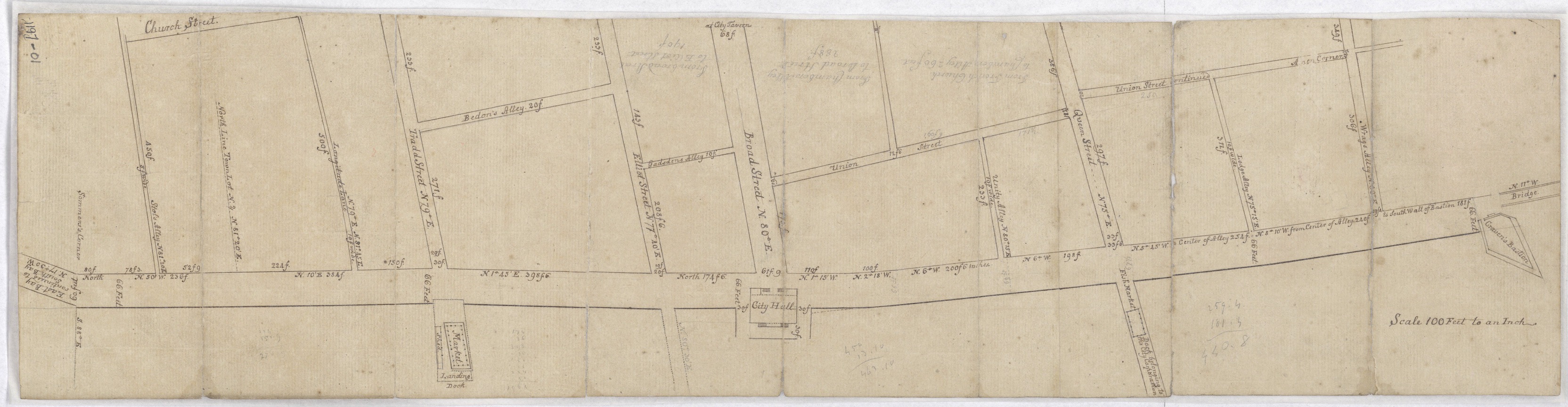
The total length of Charleston’s curtain wall is more easily determined, thanks to a detailed survey made in the spring of 1787. The parapet or upper part of the wall had been demolished by that time, and the surveyor measured the vacant space along the east side of East Bay Street. From the northern wall of Granville Bastion to the southern wall of Craven Bastion, the length of the remnants of the curtain wall was 2,566 feet, seven-and-a-half inches, more or less.[22]
How did the curtain wall impact access to the waterfront?
The curtain wall was a controversial structure for much of its existence because it formed a semi-permeable barrier between the commercial businesses fronting East Bay Street and the wharves extending eastward into the Cooper River. To accommodate the movement of goods, people, and animals between Bay Street and ships docked at the various wharves, South Carolina’s provincial government allowed the owner of each wharf to punch a broad opening in the curtain wall at the intersection of the wharf and the wall. The earliest surviving references to this activity do not include any measurements, but later records suggest that early wharf owners were permitted to carve openings in the wall the same width as the wharves they built. With only three or perhaps four wharves along the Cooper River during the first quarter of the eighteenth century, this accommodation provided a reasonable balance between the interests of commerce and public safety.
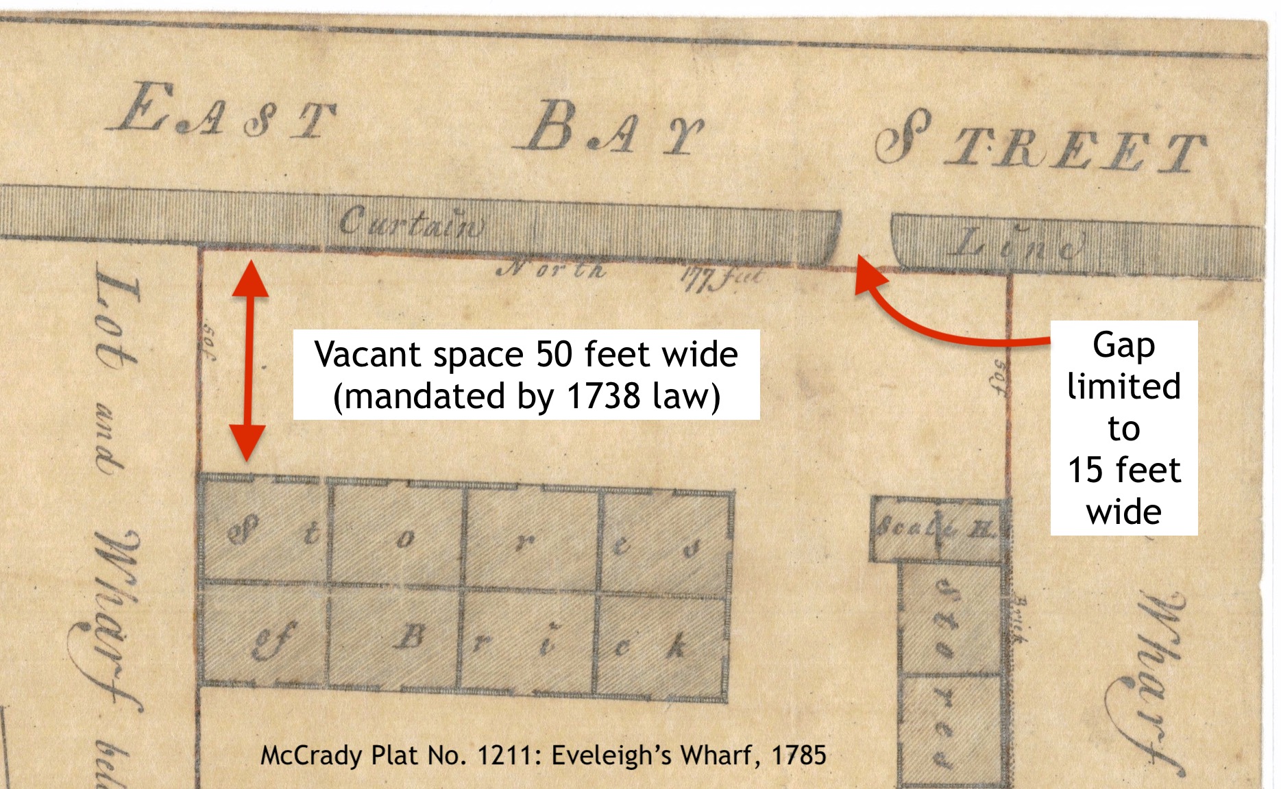
As the number of Charleston’s wharves increased during the second quarter of the eighteenth century, contemporary with rising tension between Britain, Spain, and France, the South Carolina legislature began to reconsider its waterfront priorities. A law passed in 1736 authorized builders of the new curtain wall parapet to leave “convenient openings not exceeding forty five feet for such bridges [i.e., wharves] as now extend [at least] twenty feet beyond low water mark.” Furthermore, the government invited the builders of future wharves to apply to the commissioners appointed for maintaining the curtain wall to have an opening not exceeding forty-five feet wide made to facilitate such wharf construction.[23]
Two years later, in March 1738, concerns about an imminent war with Spain inspired South Carolina’s provincial assembly to strengthen the defenses of urban Charleston. From that time forward, the government limited the maximum width of any void in the curtain wall to just “fifteen statute feet at most.” The law enacting this restriction also prohibited wharf owners from erecting any structure of any kind on their respective wharves within fifty feet of the east side of the curtain wall. These conservative limits, designed to ensure the defensibility of the capital, infuriated the merchants of Charleston because they constrained the movement of goods, people, and animals between the town and the wharves. Despite repeated complaints over the years, the restrictions remained in force until the end of the American Revolution.[24]
To ensure that wharf owners would comply with this no-build zone during the War of Jenkins’ Ear with Spain and France, the South Carolina legislature in 1745 authorized the commissioners of Charleston’s front wall “to cut and dig a moat of the breadth of twelve feet before the curtain line and round the salient angles [i.e., the redans] and half moons from Granville’s bastion to Craven’s bastion.”[25] The muddy moat, frequently filled with trash, remained open until the provincial government ordered it to be filled in late 1764.[26]
When and why was the curtain wall demolished?
The brick wall erected on the east side of East Bay Street served as the front line of Charleston’s waterfront defenses for most of the eighteenth century, but it was relegated to secondary role during the American Revolution. Between 1775 and 1783, American defenders and later the British occupation force erected and maintained several temporary gun batteries on the wooden wharves projecting into the Cooper River. These advance works diminished the utility of the old curtain wall and emphasized the degree to which it impeded traffic across the increasingly permanent landscape of man-made wharves.
The state act incorporating the City of Charleston in August 1783 transferred to the new City Council jurisdiction over several of the old fortifications within the city, including the curtain wall. A revised city charter, ratified by the state legislature in March 1784, also transferred to the City Council the power formerly vested in the commissioners of fortifications, “so far as the same relate to the pulling down or removing any building or erection on any of the wharves, or within fifty feet of the curtain line on the Bay of Charleston.”[27]
At the same time, however, the South Carolina General Assembly authorized the sale and demolition of all of the accumulated fortifications within urban Charleston (see Episode No. 74). During the remainder of 1784 and 1785, most of the city’s old bastions, redans, and batteries were sold at auction and dismantled to make way for new civilian buildings. The City Council of Charleston apparently authorized the demolition of the curtain wall during this same period, but the later loss of city records during “the Great Memory Loss of 1865” obliterated the specifics of such work. The demolished materials or spoil might have been recycled by adjacent property owners or simply used to fill low spots along the waterfront or elsewhere in the city.
Meanwhile, merchants and wharf owners of post-war Charleston continued to clamor for the right to build in what Governor Benjamin Guerard described in 1784 as “the ever dirty dock or moat immediately under the old curtain line on the Eastern Bay.”[28] The provincial law of 1738 prohibiting the erection of any structure within fifty feet to the east of the curtain wall was finally repealed by the state legislature in March 1787. The same law also authorized the City Council of Charleston to widen East Bay Street to the eastward, over the old defensive line.[29] Eight months later, in November 1787, the City Council settled an agreement with the various wharf owners of Charleston to define a new eastern boundary for the city’s principal waterfront street. That line, marked by the current sidewalk along the east side of East Bay, transformed the rather narrow and irregular colonial thoroughfare into the broad and relatively straight street we use today.
Where is the curtain wall today?
Our ability to locate the remnants of Charleston’s colonial curtain wall under the modern streetscape is complicated by the long and rather convoluted history of its evolution. As I’ve tried to demonstrate in this program, the design, dimensions, trajectory, and materials of the curtain wall evolved through a succession of construction campaigns over a period of ninety years. The significant jog created in the northern path of the wall in 1704, for example, might have been preserved by subsequent generations, or it might have been completely obliterated by later reconstruction work. Illustrations of the wall appear in numerous maps and plats created over the course of the eighteenth century, but these visual representations do not necessarily match contemporary textual descriptions of its dimensions and materials. In short, predicting the location of the remnants below the modern streetscape is no easy task.
The City of Charleston’s antebellum efforts to create a robust network of subterranean street drains punched holes through the remnants of the old curtain wall as they extended storm tunnels to the Cooper River, but few during that era cared about the history of the brickwork they destroyed. Workers excavating modern sewer lines along the edge of East Bay Street in 1911 encountered “a solid wall of masonry” at the east end of Cumberland Street and paused to admire the robust but mysterious construction. A reporter at the scene noted that the brickwork “follows a straight line down East Bay,” but could not identify the purpose of the structure. “Had one the time to follow these excavations,” he said, “some interesting ‘finds’ could no doubt be made, bearing upon the early history of old Charles Town.”[30]
Since 2005, the volunteer members of the Mayor’s Walled City Task Force have been collecting data related to the colonial fortifications of urban Charleston, sharing their discoveries with the public, and advocating for the protection of the surviving materials. With limited opportunities for invasive excavations into the modern streetscape, the Task Force has relied on documentary research and ground penetrating radar to locate and predict the path of the old curtain wall.
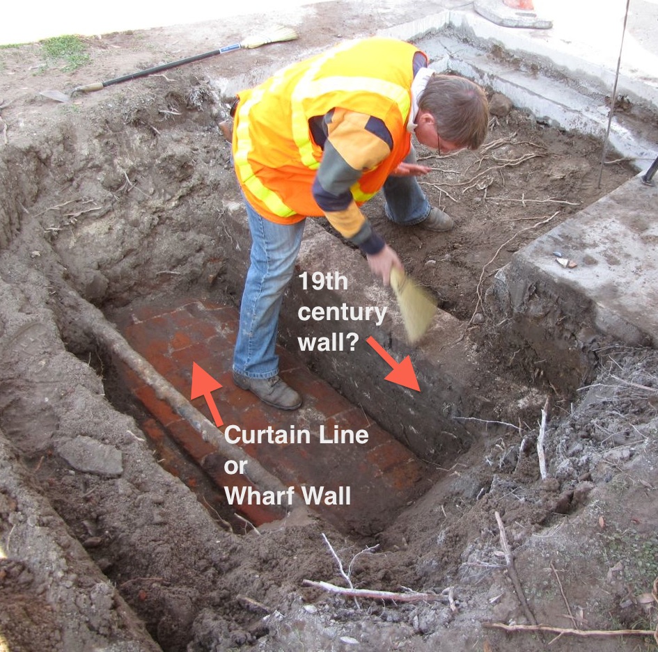
During a one-day dig in January 2013, near the southeast corner of East Bay Street and South Adgers Wharf, team members located and briefly exposed a small segment of the top of the surviving remnants of the curtain wall. At that location, the wall stands just below the modern surface, midway between the street and the adjacent sidewalk. At other locations along the length of East Bay, however, the path of the curtain wall deviates from that of the modern street. The southern end of the wall, for example, runs under the concrete sidewalk from the northern edge of the Missroon House (40 East Bay Street). From the north side of the Old Exchange Building, the wall appears to continue northward through the eastern parking lane of the present street. At the northern end of the wall, the line of the surviving brickwork runs under the center of the broad sidewalk in front of the U.S. Custom House (200 East Bay Street) and intersects with the southern face of Craven Bastion at a site very near the southwestern pillar of the steps in front of the Custom House.
The landscape to the east of East Bay Street has evolved significantly since the demolition of the curtain wall parapet in the 1780s. Acres of made land covered with substantial buildings now occupy the tidal mudflats of early Charleston. The colonial-era curtain that once stood along the edge of East Bay was leveled and forgotten more than two centuries ago, but its legacy survives in the modern world. The long campaign to maintain a robust barrier between the town and the sea fueled the development of wharves, warehouses, and residences that gradually reclaimed land once overflowed by the Cooper River. As the peninsular city grapples to define its future relationship with the surrounding waters, the story of Charleston’s original curtain wall seems especially relevant.
[1] See sections 8 and 9 of Act No. 232, “An Act for the better securing of Charlestown, by stopping the North Barr of Ashley River, in case of invasion; and to disband the Military Watch in Charlestown,” ratified on 4 November 1704, in David J. McCord, ed., The Statutes at Large of South Carolina, volume 7 (Columbia, S.C.: A. S. Johnston, 1840), 40–41.
[2] See the first section of Act No. 264, “An Act for Repairing and Expeditious Finishing the Fortifications in Charlestown,” ratified on 12 July 1707, in McCord, Statutes at Large of South Carolina, 7: 43–47.
[3] South Carolina Department of Archives and History (hereafter SCDAH), Journal of the South Carolina Commons House of Assembly, 1712–15 (Green’s transcription), 181 (19 November 1713).
[4] See Act No. 345, “An Additional Act to an Additional Act to an Act, entitled ‘An Act for preventing the Sea’s further Encroachment on the Wharfe of Charles Town, and for repairing the Bastions, Half Moon and Redoubts on the same,” ratified on 18 December 1714. An imperfect rendering of this act appears in McCord, Statutes at Large of South Carolina, 7: 60–65, but the original, complete text is found among the engrossed acts at SCDAH, series S165001.
[5] See Act No. 416, “An additional Act to an Act entitled An Additional Act to an Act now in force relating to the Fortifications of Charlestown,” ratified on 13 February 1719/20. An imperfect rendering of this act appears in McCord, Statutes at Large of South Carolina, 7: 72–73, but the original, complete text is found among the engrossed acts at SCDAH, series S165001.
[6] The text of Act No. 503, “An Act for preventing the Sea’s further encroachment upon the Wharfe or street commonly called the Bay, in Charlestown, and for the expeditious repairing and finishing the Front Wall thereof,” 17 April 1725, does not appear in the published Statutes at Large of South Carolina, but the full text is found among the engrossed acts at SCDAH, series 165001.
[7] See Act No. 604, “An Act for Repairing the Old and Building of New Fortifications for the Security and defence of this Province from Attacks by Sea and for appointing Commissioners for carrying on such Works, and for continuing New Church Street and Little Street to Ashley River,” ratified on 29 May 1736 and found among the engrossed acts at SCDAH, series 165001; and section 12 of Act No. 619, “An Act to enable the Commissioners herein named to stamp and sign certain Orders . . . for the speedy finishing of the curtain line in Charlestown,” ratified on 5 March 1736/7, in Thomas Cooper, ed., The Statutes at Large of South Carolina, volume 3 (Columbia, S.C.: A. S. Johnston, 1838), 461–64.
[8] See Act No. 645, “An Act for the immediate building up a Curtain Line before Charlestown Bay, and piling in the front Lots on Ashley River, and from White Point to Vanderhorst’s Creek,” ratified on 25 March 1738, in Cooper, Statutes at Large of South Carolina, 3: 492–97. This act was similar to several other contemporary laws appointing commissioners to undertake various duties within urban Charleston, as described in Episode No. 56.
[9] Numerous references to the reconstruction of the curtain wall can be found in the published transcriptions of the several Journals of the South Carolina Commons House of Assembly, 1752–1755.
[10] See the descriptions of legislative acts numbered 110 and 131 in Episode No. 180 and No. 181, respectively.
[11] See the multiple revisions of “An Act to Prevent the Seas further Encroachment upon the Wharf of Charles Town, ratified on 16 November 1700 (Act No. 173), 23 December 1703 (Act No. 219), 18 December 1714 (Act No. 345), 17 April 1725 (Act No. 503), as well as the aforementioned Act No. 416 of 1719/20, and the aforementioned Act No. 604 of 1736.
[12] See the aforementioned Act No. 645 of 1738.
[13] The aforementioned Act No. 503 of 1725 was the first to mandate that the wall “be planked underneath with plank of two inch thick,” but the builders probably followed that practice from the 1690s forward. The excavation at South Adgers Wharf performed by the Mayor’s Walled City Task Force in June 2009 found well-preserved cypress planks, two inches thick, resting on wooden piles approximately two feet long, below the brickwork forming the redan at the east end of Tradd Street. Images of that work can be found on the blog of the Task Force, 25 June 2009, “Tradd Street Redan Dig, Day 19.”
[14] Charleston Time Machine Episode No. 210 includes a discussion of the piles in question.
[15] See section 10 of the aforementioned Act No. 345 of 1714.
[16] See the first section of the aforementioned Act No. 416 of 1719/20.
[17] See the aforementioned Act No. 604 of 1736.
[18] See the fortification report submitted by Colonel Othniel Beale, “chief engineer” of fortifications, to the legislature, in J. H. Easterby, ed., The Colonial Records of South Carolina: The Journal of the Commons House of Assembly, February 20, 1744–May 25, 1745 (Columbia: South Carolina Archives Department, 1955), 225 (4 July 174).
[19] Peter Henry Bruce, Memoirs of Peter Henry Bruce, Esq. A Military Officer, in the Services of Prussia, Russia, and Great Britain (London: T. Payne and Son, 1782), 384.
[20] See Gentleman’s Magazine [London], volume 15, January 1744/5, page 30, “The case of Carolina consider’d, with regard to its danger of being invaded, for want of regular forces, by George Burringtone, Esq.”
[21] See the report of the Commissioners of Fortifications in Terry W. Lipscomb, ed., The Journal of the Commons House of Assembly, November 12, 1754–September 23, 1755 (Columbia: University of South Carolina Press for the South Carolina Department of Archives and History, 1986), 103 (4 February 1755).
[22] Wharf Owners to the City of Charleston, lease and release and plat, 19–20 November 1787, recorded in Charleston County Register of Deeds, A8: 1–4. The dimension 2,566 feet 7.5 inches is derived from a table of seventeen sequential measurements made along the length of East Bay Street by surveyor Barnard Beekman.
[23] See the aforementioned Act No. 604 of 1736.
[24] See Section 5 of the aforementioned Act No. 645 of 1738.
[25] See section 7 of Act No. 729, “An Act for imposing an additional duty of six pence per gallon on Rum imported . . . for the defence of Charlestown,” ratified on 25 May 1745, in Cooper, Statutes at Large of South Carolina, 3: 653–56.
[26] See section 2 of Act No. 927, “An Act to Empower Certain Commissioners therein mentioned, to keep clear and in good order and repair the streets of Charlestown; and for establishing other regulations in the said town,” ratified on 10 August 1764, in David J. McCord, ed., The Statutes at Large of South Carolina, volume 9 (Columbia, S.C.: A. S. Johnston, 1841), 697–705.
[27] See sections 4 and 5 of Act No. 1228, “An Act to Explain and Amend An Act Entitled ‘An Act To Incorporate Charleston;’ and to Enlarge the Powers of the City Council,” ratified on 26 March 1784, in McCord, Statutes at Large of South Carolina, 7: 101–2.
[28] See Theodora J. Thompson and Rosa Lumpkin, eds. Journals of the House of Representatives, 1783–1784. Columbia: University of South Carolina Press, 1977), 530 (8 March 1784).
[29] The full text of Act No. 1366, “An Act for repealing such Acts of Assembly as regulate and restrict the erection of houses below the Curtain Line on the Bay of Charleston; to widen Bay-street, and to permit houses of any size to be erected to the eastward of the same,” ratified on 27 March 1787 does not appear in the published Statutes at Large of South Carolina, but the full text is found among the engrossed acts at SCDAH (series S165001); the text also appeared in Charleston Morning Post, 28 April 1787, page 2.
[30] For more information about these early sewer drains, see Christina Rae Butler, Lowcountry at High Tide: A History of Flooding, Drainage, and Reclamation in Charleston, South Carolina (Columbia: University of South Carolina Press, 2020). The quotation appears in [Charleston] Sunday News, 26 March 1911, page 8, “Remains of Old City Found by Sewer Diggers,” by J. I. W.
NEXT: Charleston's First Black Detectives, 1869–1886
PREVIOUSLY: Savannah Highway: The Private Roots of a Public Thoroughfare
See more from Charleston Time Machine