In the spring of 1751, Governor James Glen described the Cooper River as “a kind of floating market,” hosting “numbers of canoes boats and pettyaguas that ply incessantly, bringing down the country produce to town.”[1] In today’s Time Machine, let’s follow those watercraft to a series of market sites along the Charleston waterfront and explore the daily routine of vending fresh victuals during the community’s first century.
The European immigrants and enslaved Africans who trickled into the Lowcountry of South Carolina during the 1670s generally raised their own food and bartered surplus provisions with their neighbors. There were few roads during those early years beyond ancient footpaths, but newcomers pushing farther inland to establish larger plantations spawned an expanding network of public roads that nurtured the flow of commerce across the landscape.

The pace of such colonial development accelerated after the spring of 1680, when the nascent provincial government moved the capital from Albemarle Point, west of the Ashley, to the peninsula called Oyster Point at the confluence of the rivers Ashley and Cooper. The broad waterfront of “New Charles Town,” just six miles from the Atlantic Ocean, held the potential to become a busy port for trans-Atlantic and inter-colony shipping, but the site presented a logistical challenge to local commerce: There were no bridges linking the peninsula to the rural plantations west of the Ashley or east of the Cooper. Country folk wishing to send market goods to town by horse and cart had to rely on small ferry boats to cross various rivers to the peninsula, where there was just one dirt road, called the “Broad Path,” leading down the Neck to the colonial capital. Unless you were driving a herd of cattle from the hinterland, it was usually faster and easier to load a boat full of market goods and float downstream with the ebbing tide.
By the 1690s, the owners of rural plantations had adopted a custom of sending their surplus produce to Charleston in various types of watercraft managed by enslaved men and women. The same vessels and caretakers also transported numbers of small animals like calves, sheep, lambs, goats, pigs, and fowl, intended to be killed and butchered at the point of sale in the capital. Their destination was the town’s first wharf, a low bluff barely above the reach of high tide, now called East Bay Street. Beaching their craft along the grassy mudflat before the town, they could carry goods ashore and haggle with customers at any point along the public wharf.
That informal market practice began to change in 1694, when South Carolina’s provincial legislature authorized the construction of a half-mile-long brick wall along the east side of the wharf we call East Bay Street. The resulting structure, known as the “front wall” or “curtain line,” protected the street from encroaching tidewater, but it also impeded movement between the water and land. To facilitate the growth of commerce in Charleston, the Lords Proprietors of the Carolina Colony decreed that every person owning a lot on the west side of the Bay Street could claim and develop the mudflat fronting their respective property on the east side of the street, on two conditions: First, that the community had to preserve the space at the east end of Tradd, Broad, and Queen Streets for public use, and secondly, “that there may be a [public] wharf for ye other inhabitants to land their goods at without charge.”[2]

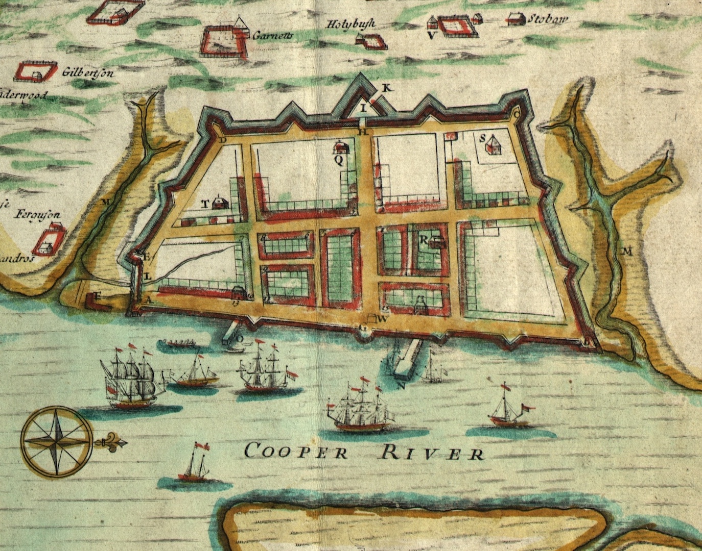
Accordingly, in August 1701, in the midst of a campaign to construct brick fortifications along the curtain line to defend Charleston against potential invasion, the provincial government designated two public landing places for boats along the Cooper River waterfront. Each measured just twenty feet wide, situated to the immediate south and north of the Half-Moon Battery then under construction at the east end of Broad Street. Here we can imagine canoes and small boats beaching in front of the two landings and vendors carrying ashore live mammals as well as baskets, sacks, and crates filled with fruit, vegetables, fish, and shrimp. Because the designated landing sites were too small to accommodate crowds of vendors, customers, and produce, their market activity migrated a dozen or so paces to the west, congregating in the middle of the town’s principal street, near the brick Watch House that stood within the footprint of the Half-Moon Battery. This improvised market site gained legitimacy in April 1710, when the South Carolina General Assembly declared it to be the official “Public Market in Charles Town . . . near the Watch House . . . at the [east] end of Broad als Cooper Street” (see Episode No. 254).
During the succeeding generation, the growth of both waterfront infrastructure and the town’s urban population transformed local opinion about the public market in lower Broad Street. The construction of several private “bridges” or wharves extending eastward from the curtain wall to the channel of the Cooper River facilitated a boom in ship traffic that crowded and eventually usurped the small public landing places next to the Half-Moon Battery. On shore, swelling numbers of inhabitants and horse-drawn vehicles bred frustration with the market obstructions in the town’s principal intersection at Broad and East Bay Streets. After years of complaints about such nuisances, the assembly agreed in 1733 to move the town’s sole market to the northeast corner of Broad and Meeting Streets, a site forming one quadrant of the “Market Square” designated in the original plan or Grand Model of Charleston.
While work progressed to remove old fortifications obscuring parts of Market Square, some local inhabitants petitioned the government to designate a similar public marketplace on the waterfront. Members of the provincial legislature then considered two potential sites for the proposed market, a spot at the east end of William Elliott’s wharf, opposite the east end of Elliott Street, or the public mudflat at the east end of Tradd Street.[3] In May 1736, shortly after the erasure of the old market in the middle of Broad Street, the General Assembly empowered a newly-created board of Commissioners of the Markets to establish a new facility at some “convenient place on the Bay of Charles-Town, between the front wall or [curtain] line and low-water mark.” The resulting “Bay Market,” as it became known, was officially appointed “to be the public market in Charles-Town, for selling and exposing for sale beef, mutton, veal, lamb, pork and other butchery ware, poultry, fish, herbage, fruit and other good and wholesome provisions whatsoever,” opening at sunrise every day except Sunday “for the resort of all or any [of] the inhabitants of this province, for buying and purchasing any the provisions sold or offered to sale therein.”[4]

Everyone residing in or visiting Charleston in the late 1730s knew the location of the new waterfront market, but few references to it survive from that period. Fortunately, the well-known map or Ichnography of Charles Town at High Water, published in 1739, provides visual evidence and a helpful caption identifying the location of the “Bay Markets” (plural) on the north side of what was then known as the “Middle Bridge” or wharf, east of Elliott Street and slightly south of the Half-Moon Battery. The market site was at least one hundred feet east of the brick curtain line, and, according to the 1739 map, was accessible by watercraft at high tide. The aforementioned illustration depicts a rectangular structure at the edge of a wharf owned by the Elliott family, but no details of the market’s construction or dimensions survive.
The Bay Market established in 1736 became a gathering place for the vendors and purchasers of fresh victuals. Scores of notices and complaints published in local newspapers of the eighteenth century demonstrate that most of the people attending the markets of Charleston were enslaved men and women of African and/or Indigenous ancestry, either sent by their urban owners to purchase food for their families or sent by plantation owners to dispose of surplus provisions in town. That body of documentary evidence includes one of the earliest-known references to enslaved fishermen docking at the waterfront, a cultural phenomenon that later became known as the “mosquito fleet” of Charleston. The Black men who daily sailed and rowed small wooden boats many miles offshore and returned with piles of fresh fish during the 1730s and 1740s landed their catch at the Bay Market, where they could mend their equipment on the adjacent mudflat and socialize with friends and family visiting the marketplace. When an enslaved young man called Peter ran away from bondage in the autumn of 1737, for example, his owner offered a reward for his capture, advising neighbors that Peter was “well known in Charlestown, and has been lately seen with the fishing Negroes, at the Markett place on the waterfront.”[5]
The small fishing boats and other types of open craft visiting the Bay Market were not the only vessels traversing local waterways, of course. At the wharf-side they navigated around large sailing ships bringing cargo and people from other colonies, Africa, and England, as well as mid-sized plantation schooners delivering bulk commodities like barrels of rice and pitch intended for export or barrels of corn and peas for wholesale. Each of these larger vessels required a berth alongside one of the wooden wharves extending into the Cooper River and paid various fees to the wharf owner for the privilege. Boats bringing fresh food to the Bay Market were supposed to be exempt from such fees, but that custom changed in the late 1740s as war between Britain, Spain, and France stifled the volume of trans-Atlantic and inter-colony shipping. Perhaps trying to augment declining profits, the proprietors of the wharf under the Bay Market began demanding tolls from small boats seeking access as customary. This novel imposition, in turn, reduced the volume of fresh provisions landing at the site and prompted some citizens to petition the government for redress.
Reacting to numerous grievances voiced by residents of urban Charleston, the South Carolina General Assembly compiled a lengthy bill in the spring of 1750 for the better regulation of the unincorporated capital. One of the complaints expressed the need for “a market for the convenience of persons bringing things by water,” a trade discouraged “by reason of a very large toll being exacted from such persons by the proprietors of the place now made use of for that purpose.” In response, the legislature agreed to secure “a proper piece of land” on the waterfront for a marketplace and to empower the Commissioners of the Markets “to erect proper buildings to shelter persons from the weather who shall tend the said market.”[6]

The thirty-first paragraph of the aforementioned bill, ratified in May 1750, acknowledged that “several persons living in the country who bring down grain and other provisions to sell in Charles Town are put to great inconvenience and expence for want of a market near the water side.” To improve the situation, the legislature empowered the market commissioners “to erect shades [that is, a wooden shed with open sides] on the piece of land belonging to the public[,] being part of a low-water lot on the Bay of Charles Town fronting Tradd Street for a public market,” or to purchase a similar lot between Tradd and Elliott Streets, “for the use of a public market as the said commissioners shall judge most expedient[,] and to erect shades thereon for a market.” The waterfront property in question was to be reserved for the use of the public, including free access along the edge of the Cooper River. Funds for the market’s construction came directly from the public treasury, but the law required the commissioners to reimburse the government using income from daily rental fees collected by a market clerk from vendors hiring stalls within the shed-like structure.[7]
The commissioners thereafter contracted to build the new market of 1750 on public land at the eastern terminus of Tradd Street, but the site was not entirely vacant. The campaign to raise defensive fortifications along the curtain line during the early years of the eighteenth century (see Episode No. 249) included the construction of a large V-shaped battery, called a redan, projecting from the east end of Tradd Street towards the river. Measuring at least fifty feet along each of its two eastern walls, the solid brick redan was designed to mount several cannons projecting over the ramparts, but the iron guns were often stored within the provincial armory in Meeting Street. Regardless of its armament, the footprint of the Tradd Street redan obliged the market commissioners to build their new shed a short distance farther to the east, closer to the water’s edge at high tide.
The public land at the east end of Tradd Street measured thirty-three feet wide—the same breadth as the street—and extended 300 feet from the curtain line to the river, but the market commissioners pledged to keep the eastern half of the site unobstructed “for the coming in and going out of all boats, canows and other vessels to the said market.”[8] The precise dimensions of the shed are lost, but it was a rectangular timber-frame structure supported by posts driven into the grassy mudflat. A hip roof sheltered a largely open space divided by rows of stall boards for the use of vendors who likely stood atop an earthen floor littered with crushed oyster shells. The new market was completed by the end of 1750, then leveled by a powerful hurricane in September 1752, and promptly rebuilt at the beginning of 1753.[9]

Charlestonians of the early 1750s browsed a similar variety of meat and vegetables within the town’s two public markets, separated by a quarter-mile of urban landscape, but an important distinction between them soon emerged. The older brick structure at the northeast corner of Market Square, then considered the “upper end” of Broad Street, was sometimes called the “Upper Market,” while the wooden structure at the east end of Tradd Street, in the “lower” part of the town, became known as the “Lower Market.” Because the Upper Market abutting Meeting Street was more easily accessible by carts and cattle entering town via the Broad Path, it became known as the Beef Market by 1755. In contrast, the waterfront Lower Market became the principal venue for the sale of seafood and “small meats” like calves, sheep, lambs, goats, and juvenile pigs called “shoats” that arrived by boat from plantations upstream.[10] Butchers both Black and White slaughtered such animals on the mudflat adjacent to the marketplace, a site washed by the daily tides, then hung the flesh from hooks above their rented stalls to vend by the carcass or by the joint. Some of the enslaved persons attending the market might have collected some of the discarded offal for their own sustenance, transforming them into regional delicacies like tripe, pigs’ feet, fatback, and chitterlings. Waste was antithetical to the people of eighteenth-century Charleston. Local boot- and shoe-maker Patrick Hinds, for example, kept an enslaved “hand” at the Lower Market to purchase animal skins directly from the butchers.[11]
Sometime between 1763 and 1766, the Market Commissioners erected an additional structure at the east end of Tradd Street, immediately south of the Lower Market shed, “for the conveniency of country people, who attended the said markets, to put their rice, corn, pease, potatoes &c. under.” The resulting timber-frame edifice—a long, narrow, rectangle of unknown dimensions—stood on waterfront property ostensibly reserved for public use, but the commissioners soon learned otherwise. David Graeme, new owner of the ground immediately south of the Lower Market, sued the commissioners for trespass in 1768 and proved his case, then agreed to sell the northernmost edge of his wharf property to the government to legitimize the recent market expansion. The commissioners thereafter advised the provincial legislature to purchase Graeme’s remaining vacant property to preserve ample landing space for watercraft attending the public market. The tidal mudflat in question, said the commissioners in August 1769, “affords a commodious shelter for boats, from the injury of easterly winds, and serves as a drain to carry off the filth occasioned by killing such provisions, whereby the market is rendered more clean and decent.” Graeme’s plan to expand and extend his wooden wharf towards the Cooper River rendered it “absolutely expedient” for the government to act quickly, said the commissioners, “otherwise the numbers of boats [attending the Lower Market] will be diminished and every other considerable emolument be inevitably lost.” Although the assembly appointed a committee to investigate a potential purchase from Graeme, they deferred further consideration of the matter for years while the commissioner’s prediction became reality.[12]

Although the government’s purchase of the northern edge of Graeme’s Wharf in the spring of 1768 briefly improved conditions at the Lower Market, that large expense derailed a contemporary plan to create a third public marketplace in urban Charleston. The capital had witnessed the arrival of record numbers of Protestant immigrants and African captives after the conclusion of the French and Indian War in 1763, swelling the urban population and the need for provisions. These conditions inspired some residents to clamor for a separate venue dedicated to the sale of fish and seafood. A bill to fund the erection of a fish market, first mooted in February 1768, finally gained ratification in April 1770.[13] The preamble to the dual-purpose law, titled “An Act for a Fish Market, and for preserving the lamps of Charlestown,” acknowledged that “no market has been ever established by law in Charlestown for the sale of fish only, but it has been usual for persons to offer the same for sale on stands and benches on the Bay of Charlestown, and in the public streets, to the great nuisance of the inhabitants of the said town.” To corral such practices, the assembly decreed “that a public market for the sale of all sorts of fish, shall be erected and built on the low water lot belonging to the public, situate to the eastward of the Bay [Street] of Charlestown, directly opposite to Queen-street . . . with proper stalls, benches, stands, and every other conveniency to render the same clean and useful.” The sale of fresh seafood, never dried or salted fish, was to take place therein every day except Sundays, from daylight until eight in the evening. Because, as the assembly noted, “the business of fishing is principally carried on by Negroes, mulattoes and mestizoes, who are apt to be riotous and disorderly,” they directed the Commissioners of the Markets to erect a set of stocks near the market for the punishment and humiliation of malefactors.[14]
A few weeks after the ratification of the Fish Market act, the commissioners advertised their desire to contract with anyone “willing either to undertake the building of the said market, or the filling up, and making solid, the place whereon the same is to be built, and finding all the materials.”[15] Site preparation took several months and involved much filling, tamping, and grading to create a dry site with a moderate slope towards the Cooper River. The proposed eastward continuation of Queen Street, like that of Tradd Street, measured just thirty-three feet wide and extended approximately 160 feet eastward from the edge of East Bay Street to the water’s edge. Within this public space, the commissioners placed the market more than fifty feet east of the curtain line, as required by a fortification law of 1738. Later plats of the site depict a broad rectangular structure measuring nearly thirty feet wide and at least fifty feet long, dimensions likely mirroring those of the Lower Market built seventeen years earlier. Charleston’s first dedicated fish market was an interlocking timber-frame structure, raised in a single day on the 20th of September 1770. Following the addition of a hip roof and rows of interior stalls for vendors, incoming fishing boats commenced a new tradition of vending their morning catch to crowds of hungry landlubbers gathered at the east end of Queen Street.[16]
Meanwhile, back at the foot of Tradd Street, local residents demolished the Lower Market on Christmas Day 1770 to check a large fire spreading southward from Champneys’ Wharf, adjacent to the new Exchange building then under construction. The market commissioners thereafter contracted for the erection of new sheds, probably replicating the dimensions of the previous structures.[17] The continuation of the status quo at the Lower Market during the early 1770s inspired a number of residents to badger the legislature about deteriorating conditions at the site. David Graeme’s formerly-vacant waterfront had “lately been filled up,” complained a Grand Jury, and his expanding commercial wharf now constricted water access to the public landing, as predicted several years earlier. “As for want of a proper dock there, that market can be of very little use, but will rather become a nuisance, the safety of the boats frequenting the same and their contents, being thereby greatly endangered.”[18] Another group complained about various illegal practices at the Lower Market, mostly stemming from the dominating presence of Black butchers—enslaved and free—who drove prices higher to increase their personal profits.[19] The government responded by prodding white butchers to reassert control over the site, but the offending practices and the complaints continued for many more years.[20]

Perhaps as a means of demonstrating government oversight on the waterfront, the new Clerk of the Lower Market, John Calvert, began publishing half-yearly accounts of the number of animals killed, butchered, and sold at the east end of Tradd Street. From the first of September 1772 through the last day of August 1773—the first full year of statistics available—the mostly-Black butchers working at that waterfront site processed 3009 calves, 1,620 sheep, 1,799 lambs, 930 hogs, 2,857 shotes, 682 beeves, and 200 deer—a total of 11,097 animals, averaging nearly thirty-three beasts per market day.[21]
The combination of increased butchering and diminishing elbow room at the Lower Market inspired a Grand Jury in May 1773 to complain about “the present practice of killing calves, sheep, &c.,” in close proximity to the wooden shades. This “very offensive” custom “may be avoided,” they opined, “if proper posts for that purpose be erected to the eastward of said market, and near the dock,” where tidewaters might wash the blood and entrails into the Cooper River more effectively. The commissioners likely installed the requested posts at some later point in 1773, and the following spring contracted with laborers to pave the ground under both the Lower Market and the Fish Market with fields of “brick laid in mortar.”[22]
In the autumn of 1775, when hostilities commenced between rebellious South Carolinians and British forces in Charleston Harbor, the nascent state government authorized the construction of new fortifications composed of earth and palmetto logs along the Cooper River waterfront. They did not immediately dismantle the numerous low structures standing on the various wharves, but the arrival of a squadron of British warships in June 1776 triggered an order to clear or reduce in height the entire landscape east of the curtain line. Laborers definitely dismantled the Lower Market at the east end of Tradd Street, which stood directly in front of the old brick redan, but the Fish Market at the east end of Queen Street stood nearly two hundred feet from a similar redan and evidently survived the war.[23]

Despite the removal of the Lower Market sheds in the summer of 1776, the site continued to function as a depot for goods and a gathering place for auctions and daily market activity. Persistent complaints about the subversive accounting practices of Black butchers working at the east end of Tradd Street, compounded by the pervasive stink of blood and guts, induced market commissioners in June 1778 to impose a moratorium on killing or butchering animals in any of the urban marketplaces. Henceforth they directed butchers to bring such carcasses to town “properly dressed, and ready to cut up for sale.”[24] This prohibition probably did not last very long, however, as the commissioners struggled to reintroduce the same policy more than twenty years later.
American and French defenders surrendered Charleston to the British Army and Navy on 12 May 1780, after which British officials administering the capital under martial law commissioned a new board of loyal citizens to manage the three public markets. Retail food sales within the Beef Market continued as usual, but the disordered, fortified state of the Cooper River waterfront inspired some residents to vend fresh provisions at various point around the crowded town. To check this unregulated practice in February 1781, the British commandant ordered that henceforth “all fresh meats, victuals and provisions of every kind, (fish excepted) shall be openly sold in one or other of the publick markets, and no where else in Charlestown, or within a mile thereof, on penalty of forfeiture.” A new wooden shed rose at the Lower Market in late November 1781, the fourth iteration at that site, after which the loyalist commissioners began offering cash bounties to encourage fishermen to bring larger quantities of fish to the market at the east end of Queen Street.[25]
The conclusion of the American Revolution in the spring of 1783 marked the beginning of a new era for the public markets of urban Charleston. In the next episode, we’ll continue the narrative through the turn of the nineteenth century and unravel a long-forgotten conundrum that nearly erased the present market in Market Street.
[1] H. Roy Merrens, ed., The Colonial South Carolina Scene: Contemporary Views, 1697–1774 (Columbia: University of South Carolina Press, 1977), 181.
[2] Lords Proprietors to their deputies at Charleston, 24 April 1694, in BPRO, Board of Trade, Carolina records, Vol. 4, pp. 13–14, published by A. S. Salley Jr., indexer, Records in the British Public Record Office Relating to South Carolina 1691–1697 (Atlanta: Foote and Davies for the Historical Commission of South Carolina, 1931), 119–23.
[3] South Carolina Department of Archives and History (hereafter SCDAH), Journal of the South Carolina Commons House of Assembly, 1731–33 (Mr. Sainsbury’s transcription), 995 (5 April 1733); Journal of the South Carolina Commons House of Assembly, No. 9, Part 2, 648–49 (7 May 1736).
[4] The full text of Act No. 598, “An Act for Regulating the Markets in the Parish of St. Philip’s, Charles-Town, and for preventing Forestalling, Ingrossing, Regrating, and unjust Exactions in the said Town and Market,” ratified on 29 May 1736, is found in CO 5/414 at the National Archives, Kew; and in South Carolina General Assembly, Acts Passed by the General Assembly of South-Carolina, at a Sessions begun and holden at Charles-Town, the Fifteenth Day of November in the Seventh Year of the Reign of Our Sovereign Lord George the Second, by the Grace of God, of Great-Britain, France and Ireland, King, Defender of the Faith, &c. Annoque Domini One Thousand Seven Hundred and Thirty Three, And from thence continued by divers Prorogations and Adjournments to the Twenty-Ninth Day of May, One Thousand Seven Hundred and Thirty Six (Charleston, S.C.: Lewis Timothy, 1736), 25–29.
[5] South Carolina Gazette (hereafter SCG), 29 October–5 November 1737, page 2. In this quotation and throughout this essay I have reproduced the spelling as in original document.
[6] J. H. Easterby, ed., The Colonial Records of South Carolina: The Journal of the Commons House of Assembly, March 28, 1749–March 19, 1750 (Columbia: South Carolina Archives Department, 1962), 384, 388 (2–3 February 1749/50).
[7] Act No. 775, “An Act for keeping the Streets in Charles Town clean, and establishing such other regulations for the security Health and Convenience of the Inhabitants of the said Town as are therein mentioned, and for establishing a new Market in the said Town,” ratified on 31 May 1750, the full text of which survives among the engrossed acts of the General Assembly at SCDAH.
[8] See section 4 of Act No. 787, “An additional and explanatory Act, to an Act of the General Assembly of this Province, intitled, an Act for keeping the Streets in Charles-Town clean; and establishing such other Regulations for the Security, Health and Convenience of the inhabitants of the said Town, as are therein mentioned; and for establishing a new Market in the said Town,” ratified on 4 May 1741, the engrossed manuscript of which survives at SCDAH, and in South Carolina General Assembly, Acts Passed by the General Assembly of South-Carolina, At a Sessions begun to be holden at Charles-Town, on Tuesday the Twenty-eighth Day of March, in the Twenty-third Year of the Reign of our Sovereign Lord George the Second, by the Grace of God, of Great-Britain, France and Ireland, King, Defender of the Faith, &c. and in the Year of our Lord 1749. And from thence by divers Adjournments to the 24th Day of April, 1751 (Charleston, S.C.: Peter Timothy, 1751), 12–15; Commissioners of the Public Market to Jacob Motte, lease (preceding a release, now lost), Charleston County Register of Deeds (hereafter CCRD), 26 February 1750/1, volume H6: 292–93.
[9] See the list of public expenses appended to Act No. 792, “An Act for raising and granting to his Majesty the sum of thirty-nine thousand four hundred and forty-one pounds and one farthing . . . for defraying the charges of the government for one year, commencing the twenty-fifth day of March, in the year of our Lord one thousand seven hundred and fifty, inclusive, and ending the twenty-fifth day of March, one thousand seven hundred and fifty-one, exclusive,” ratified on 17 May 1751, the full text of which survives among the engrossed acts at SCDAH; See the description of the 1752 hurricane in Charleston Time Machine, Episode No. 241 (23 September 2022), “The Mermaid and the Hornet in the Hurricane of 1752”; R. Nicholas Olsberg and Terry W. Lipscomb, eds. The Journal of the Commons House of Assembly, November 14, 1751–October 7, 1752 (Columbia: University of South Carolina Press for the South Carolina Department of Archives and History, 1977), 410 (7 October 1752); Terry W. Lipscomb, ed. The Journal of the Commons House of Assembly, November 21, 1752–September 6, 1754 (Columbia: University of South Carolina Press for the South Carolina Department of Archives and History, 1983), 78, 90, 116 (9, 20, 28 February 1753).
[10] See, for example, the advertisements of Eleazer Phillips in SCG, 4–11 May 1747, page 3, and of Peter Timothy in SCG, 25–29 June 1727, page 3; article 5 of the Grand Jury presentments in SCDAH, Journal of His Majesty’s Council for South Carolina, No. 20, pages 83–84 (14 March 1752); SCG, 17–24 February 1759, page 1, “We the Subscribers.”
[11] SCG, 14 November 1771, page 3; South Carolina and American General Gazette (hereafter SCAGG), 7–14 October 1774, page 5.
[12] South Carolina Gazette, 14–21 May 1763, page 1, “Any person or persons willing to undertake the building a New Market, on the public land adjoining Mr. Motte’s wharf, agreeable to a plan in the hands of William Bampfield, are desired to give in their proposals, on or before the 10th June next, to either of the commissioners. William Bampfield. Daniel Cannon. Robert Deas. Benjamin Baker. Thomas Liston.” Further evidence of the construction of this “new market” is obscured by the fact that the Commons House of Assembly conducted no business during the spring of 1763, owing to a protracted dispute with Governor Thomas Boone; SCDAH, Journal of the South Carolina Commons House of Assembly, No. 37, pages 520, 687–88, 694 (27 January, 11–12 April 1768); Jacob Motte Sr. and Ann, his wife, to the Commissioners of the Poor and Commissioners for Regulating the Market in Charlestown, lease and release, 15–16 July 1768, CCRD K3: 406–13; SCDAH, Journal of the Commons House of Assembly, No. 38, Part 1, pages 170–72 (18 August 1769).
[13] SCDAH Journal of the South Carolina Commons House, No. 37, Part 2, page 356 (26 February 1768); SCDAH, Journal of the Commons House, No. 38, Part 1, pages 113, 167–68 (4 and 17 August 1769); SCDAH, Journal of the Commons House, No. 38, Part 2, page 210 (7 December 1769).
[14] David J. McCord, The Statutes at Large of South Carolina, volume 9 (Columbia, S.C.: A. S. Johnston, 1841), 705–8.
[15] SCG, 3 May 1770, page 2.
[16] SCG, 20 September 1770, page 3.
[17] South Carolina Gazette and Country Journal (hereafter SCGCJ), 25 December 1770, page 2. Details relative to the erection of the third Lower Market in 1771 have not yet been found, but it definitely appeared; the secondary shed to the south, abutting the northern edge of Graeme’s Wharf, might not have been built until mid-1774, at which time it was described as being ten feet wide and seventy-five feet long; see SCGCJ, 10 May 1774, page 1.
[18] SCGCJ, 23 January 1770, page 2, Grand Jury presentment No. XXVI.
[19]SCDAH, Journal of the Commons House, No. 38, Part 3, page 483 (13 February 1771).
[20] See, for example, the advertisement of Francis Rivers and Rober Farquar in SCAGG, 20–29 January 1772, page 2; of Nathan Ellis in SCGCJ, 9 June 1772, page 3; of William Ellis in SCG, 15 February 1773; of “Veridicus” in SCG, 12 November 1772, page 1.
[21] SCG, 8 March 1773, page 3, “An exact List of the Creatures sold in the Lower Market”; SCG, 6 September 1773, page 3, “An exact List of the Creatures sold in the Lower-Market, in Charles-Town, from the First of March, to the 31st of August, 1773, inclusive, being Six Months.”
[22] SCG, 24 May 1773, page 1; South Carolina Gazette and Country Journal, 10 May 1774, page 1.
[23] See endnote #23 in Charleston Time Machine episode No. 263, “John Champneys and His Controversial Row, Part 1,” published on 4 August 2023.
[24] SCAGG, 18 June 1778, page 1; Gazette of the State of South-Carolina, 24 June 1778, page 2.
[25] SCAGG, 23 August 1780, page 1; SCAGG, 7 February 1781, page 1; [South Carolina] Royal Gazette, 14–17 November 1781, page 3; [South Carolina] Royal Gazette, 13–17 April 1782, page 1.
NEXT: The Genesis of Market Street, 1783–1789
PREVIOUSLY: The Rise of Asphalt Roadways in Twentieth-Century Charleston
See more from Charleston Time Machine