In Charleston parlance, “the Battery” is the common name for what is actually a pair of man-made seawalls that define the southern tip of the Charleston peninsula. The so-called “High Battery” measures just over 1,400 feet long and was built in the early nineteenth century to facilitate the creation of what we now call East Battery Street and White Point Garden. The so-called “Low Battery” is an adjacent seawall measuring nearly 5,000 feet in length that was built in the early twentieth century to facilitate the creation of what we now call Murray Boulevard. Collectively, these batteries afford panoramic vistas of Charleston harbor and the adjacent islands, but they’re also susceptible to being overflowed by crashing waves during strong storms and hurricanes. Furthermore, it’s become clear over the past several decades that these centuries-old walls are in need of some significant repairs. To address these issues, the City of Charleston is in the midst of a multi-year effort to stabilize, strengthen, and perhaps even enlarge these seawalls a bit. Also under consideration are various plans to improve the landscaping and perhaps to alter the flow of automobile traffic. To help our community understand the challenges posed by such multi-million-dollar projects, I think it’s important to look back at the many generations of labor that led to the creation of the present “High” and “Low” battery seawalls. Our brief journey begins nearly 300 years ago, when the entire area in question was just a bit of underwater, imaginary real estate.
Despite being separated in age by a century, the High Battery and the Low Battery have much in common. For example, they were both long-term projects intended to enhance the scenic beauty of the area. They were both massively expensive projects. And finally, both the High and Low Batteries were built on non-existent real estate. That is to say, they were both built in the water, not on beachfront property, or on a beach, or even near the water’s edge, but out in the liquid streams of the Ashley and Cooper Rivers. When a strong storm like a hurricane passes near Charleston harbor, the heightened waves often crash over these man-made seawalls and flood the adjacent homes. Such events are frustrating and costly, to be sure, but it’s important to remember that Charlestonians have been fighting this battle since the early 1700s.
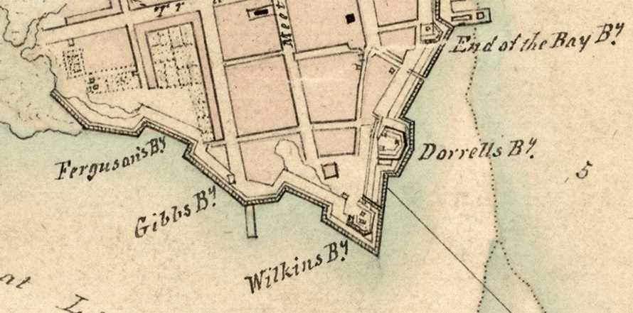
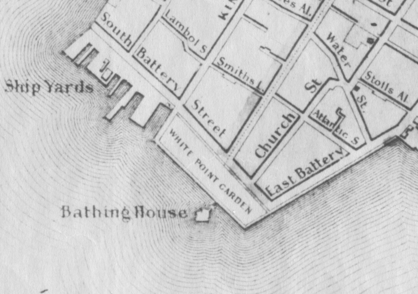
When Europeans first began settling on the narrow spit of land between the Ashley and Cooper Rivers in the 1670s, they confined their homes and farms to the highest and driest real estate available. For the first half century of Charleston’s existence, the vast majority of the homes in the town were built north of Vanderhorst’s Creek (now Water Street) and south of Daniel’s Creek (now Market Street). The term White Point, which we now use to describe the park next to the Battery at the southern tip of the peninsula, was once used in a much broader sense. In colonial-era records, the phrase “White Point” is frequently used to describe all of the land south of Vanderhorst Creek (Water Street), as far west as modern Council Street. To those early settlers, White Point was a broad, low-lying area that was “washed by the tides,” to use a common phrase from ages past. In short, 300 years ago, the land around the southernmost tip of Charleston, called White Point, was a broad, vacant beach kept clear by the potent forces of nature.
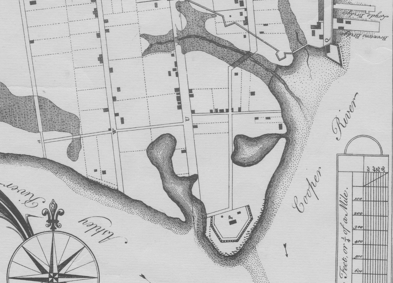
Undaunted by the effects of the devastating hurricane, South Carolina Governor James Glen brought in German-born engineer William De Brahm to design and construct new fortifications around White Point. Between 1752 and 1755 Mr. De Brahm drew three different plans for fortifying Charleston, the last of which was actually set in motion on the ground. In the late 1750s De Brahm and hundreds of laborers erected massive banks of earth, or ramparts, that formed a high, solid wall around the perimeter of White Point, from Granville Bastion (where the Missroon House stands today) south to Broughton’s Battery, and then westward to the south end of Legare Street. Atop these ramparts were erected parapet walls that shielded dozens of cannon meant to protect the southern tip of the Charleston peninsula from attack.[6]
By the time the American Revolution began in 1775, the entire southern perimeter of White Point was a heavily fortified military complex. Just fifty years earlier, however, the site had been a vacant beach that was daily washed by the tides. Between the late 1720s and the late 1760s, South Carolinians had used wood, then earth, and then brick in a sustained effort to create a hard barrier against the waters that form Charleston harbor. The purpose of these works was not simply to create viable real estate or enhance the scenic beauty, but rather to protect the fortifications that contributed greatly to the security of the town. In that respect, the late-colonial-era seawalls around White Point served their purpose adequately, but no one expected them to last forever.
In the aftermath of the American Revolution in the mid-1780s, the South Carolina legislature gave the newly incorporated City Council of Charleston permission to demolish the accumulated fortifications around the city. The bricks used to build Broughton’s Battery in the late 1730s were knocked down and sold at auction. The earth forming William De Brahm’s 1750s ramparts was leveled and spread across the neighborhood around White Point. The brick seawall constructed in the late 1760s continued to be useful, and so it was preserved well into the early 1800s. Contemporary with the de-militarization of White Point in the mid-1780s, however, the City of Charleston was making plans to create new real estate out of the mud that stood in front of the existing sea wall.[8]
The task of continuing East Bay Street southward to White Point was an expensive venture, so it took the city government a decade to secure the real estate and the capital necessary to begin the project. In the meantime, the outbreak of a new war between Britain and France in 1793 prompted the construction of a new fortification at White Point. Fort Mechanic, so-called because it was constructed by local tradesmen, was built in the mid-1790s on the site of a colonial-era fortification facing the Cooper River waterfront. In order to clear the new fort, the projected route of the new extension of East Bay street had to be pushed a bit to the east, further into the waters around White Point.[10]
The work of building a new seawall in the stream of the Cooper River commenced in the mid-1790s, using square “hog pens” of palmetto logs filled with ballast stone to weigh them down. After a couple of years of work, the hurricane of 1797 washed it all away. Construction began anew in 1798, but the hurricane of 1800 again ruined the work. Switching to more durable materials, the city commenced building a brick seawall in 1801. After that work was entirely demolished by the powerful hurricane of 1804, the city cooled its heels and did nothing for several years.[11]
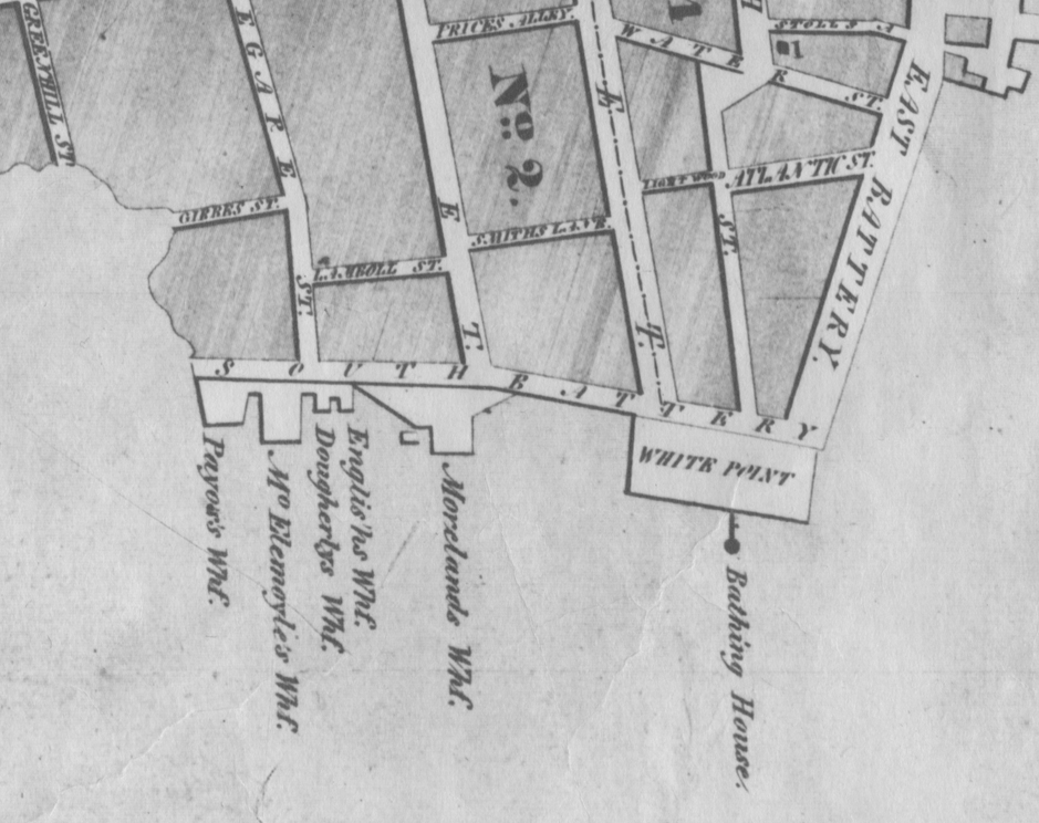
In the first two decades after the completion of the seawall we now call the “High Battery,” the land behind the wall was almost entirely vacant. The colonial-era fortifications were long gone, and the brick seawall constructed in 1768 was now entirely obscured by the southward extension of East Bay Street behind the new seawall. In a brief episode of extravagant optimism in 1836, Charleston’s city government proposed transforming this vacant expanse into a broad public pleasure garden. A sudden downturn in the economy in 1837 forced the city to curtail its plans, however, and the city’s first public park was confined to a much smaller space at the southern extremity of East Bay Street (now called East Battery Street). Between 1837 and 1838, contractors built what they called a “wharf wall” of palmetto logs that enclosed a watery square from the southern end of the Battery seawall to the southern end of Meeting Street. After filling the square with earth and planting trees and shrubs, the city opened White Point Garden to the public in 1838.[13]
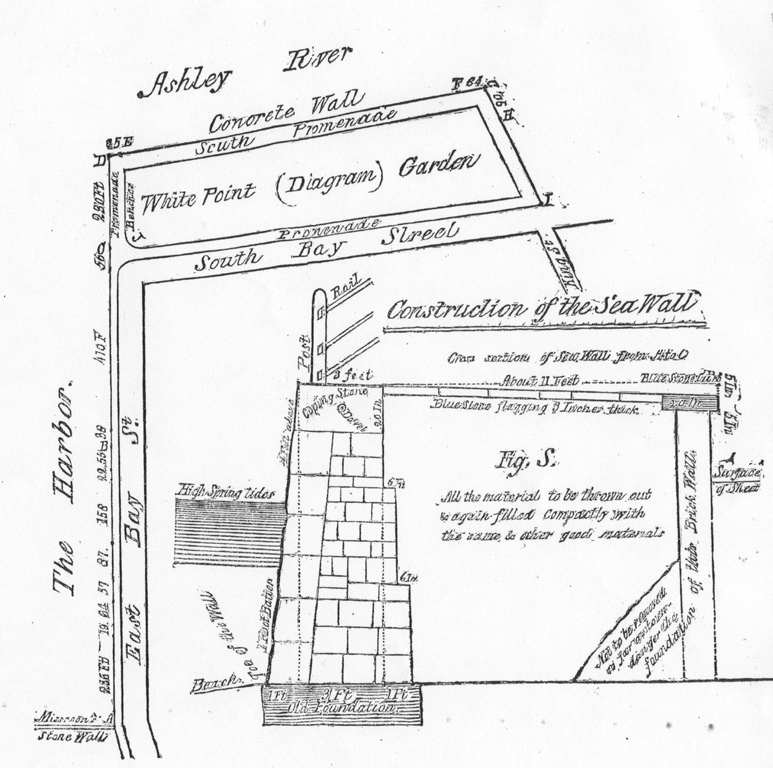
Between the completion of the city’s now-famous granite seawall in 1818 and the completion of White Point Garden in 1852, Charleston did not experience the arrival of any major hurricanes. That fortuitous streak ended in September 1854, however, when the arrival of a massive storm caused extensive damage to the battery and the walls surrounding White Point Garden. City engineer Charles Parker made a thorough inspection of the works and in 1855 filed a detailed report that included his recommendations for repairing the battery seawall and raising its height. When you stand on the “High Battery” today and watch the tidal waters crash against the stone blocks, you can thank Charles Parker for giving you a bit of extra height above the waves.[15]
And for the purposes of our story, this also seems like the logical place for a break. Tune in next week, when we’ll continue this epic journey from the era of the American Civil War to the twenty-first century, focusing on the genesis the Low Battery and the latest efforts to improve that century-old seawall.
[1] Act No. 503, “An Act for preventing the Sea’s further encroachment upon the Wharfe or street commonly called the Bay, in Charles Town, and for the expeditious repairing and finishing the Front Wall thereof,” ratified on 17 April 1725; this act was not included in the publication compilation of The Statutes at Large of South Carolina, the engrossed copy is found among the manuscript acts of the General Assembly at the South Carolina Department of Archives and History (hereafter SCDAH).
[2] Act No. 604, “An Act for Repairing the Old and Building of New Fortifications for the Security and defence of this Province from Attacks by Sea and for appointing Commissioners for carrying on such Works: and for continuing New Church Street and Little Street to Ashley River,” ratified on 29 May 1736; This act was not included in the publication compilation of The Statutes at Large of South Carolina, the engrossed copy is found among the manuscript acts of the General Assembly at SCDAH.
[3] Act No. 645, “An Act for the immediate building up a Curtain Line before Charlestown Bay, and piling in the front Lots on Ashley River, and from White Point to Vanderhorst’s Creek,” ratified on 25 March 1738, in Thomas Cooper, ed., The Statutes at Large of South Carolina, volume 3 (Columbia, S.C.: A. S. Johnston, 1838), 492–97.
[4] J. H. Easterby, ed., The Colonial Records of South Carolina: The Journal of the Commons House of Assembly, September 14, 1742–January 27, 1744 (Columbia: South Carolina Archives Department, 1954), 99–101, 236–37, 239; Act No. 701, “An Act for making satisfaction to proprietors whose lands are in any wise damnified by the works lately erected and now erecting and carrying on, or which may be thought necessary to be erected and provided for by the General Assembly, for the defence of Charlestown, and for vesting the lands on which they said works stand or may stand, in the public forever,” ratified on 7 May 1743, in Cooper, Statutes at Large of South Carolina, 3: 606–8.
[5] See the reports of hurricane damages in South Carolina Gazette, 19 September and 27 September 1752.
[6] The paper trail of De Brahm’s work in Charleston is extensive but incomplete; for details, see the published journals of the South Carolina Commons House of Assembly, 1755–59, the manuscript “Journal of the Commissioners of Fortifications” at SCDAH, and Louis De Vorsey, ed., Report of the General Survey in the Southern District of North America (Columbia: University of South Carolina Press, 1971).
[7] Details related to the construction of the seawall around White Point in 1768–69 are found in the manuscript journals of the South Carolina Commons House of Assembly, Nos. 37 and 38, and the manuscript “Journal of the Commissioners of Fortifications” at SCDAH.
[8] See Episode No. 74, "Demilitarizing Urban Charleston, 1784–1789."
[9] The southward continuation of East Bay Street was authorized by the state and city governments in Section XXVIII of Act No. 1282, “An Act for keeping in repair the several High-Roads and Bridges throughout this State, and for laying out the several new Roads and Ferries therein mentioned,” ratified on 24 March 1785, in David J. McCord, ed., The Statutes at Large of South Carolina, volume 9 (1841), 292–301; and “An Ordinance for continuing East-Bay street to the southward of the City, and for the securing the east part of White-Point from the Sea,” ratified on 6 May 1785, in Alexander Edwards, comp., Ordinances of the City Council of Charleston, In the State of South Carolina, Passed since the Incorporation of the City (Charleston, S.C.: W. P. Young, 1802), 28.
[10] Owing to the loss of city records in 1865 (see Episode No. 79), most of the documentation of the southward extension of East Bay Street in the late eighteenth century have been lost. Changes to the trajectory of the extension can be seen by comparing plats created before and after 1795; see, for example, McCrady Plats 206, 1220, and 1224 (held by the Charleston County Register of Deeds Office).
[11] For information on the hurricanes of 1797 and 1800, see Episode No. 3; for the hurricane of 1804, see Episode No. 4; for information about the funding of these early seawalls, see Episode No. 54, "Denmark Vesey's Winning Lottery Ticket."
[12] A brief summary of the funding to rebuild the seawall, 1809–18, appears in Episode No. 54, "Denmark Vesey's Winning Lottery Ticket." According to a recapitulation of city finances published in City Gazette, 1 September 1809, work on the battery seawall recommenced on 28 June 1808. According to a “Communication” published in Charleston Courier, 13 June 1818, the new “Charleston Battery” promenade was being used by pedestrians.
[13] Details related to the creation of White Point Garden can be found among the minutes of City Council, official transcripts of which appear in the extant Charleston newspapers of 1836–1838; useful summaries of this work appear in [Henry Laurens Pinckney], Report: Containing a Review of the Proceedings of the City Authorities, from the 4th September, 1837, to the 1st August, 1838, with Suggestions for the Improvement of the Various Departments of Public Service. Presented to the City Council, August 6, 1838, by Henry L. Pinckney, Mayor (Charleston, S.C.: Thomas Eccles, 1838), 14–19, 28, 32; H. L. Pinckney, A Report Containing a Review of the Proceedings of the City Authorities, From First September, 1838, to First August, 1839. Presented to the City Council on the 6th August, 1839 (Charleston, S.C.: W. Riley, 1839), 19, 25–27, 32.
[14] Copious details related to construction of new seawalls (made of concrete, stone, and brick) around White Point Garden, the westward extension of the Garden from Church Street to Meeting Street, and the filling and landscaping of the expanded Garden, are found among the minutes of numerous City Council meetings between early 1846 and late 1852; owing to the loss of city records in 1865, these minutes surviving only in the extant Charleston newspapers of that era.
[15] Charles Parker, White Point Garden and the Battery: The Latter Part of the Report of Charles Parker, City Surveyor, to the City Council, Relating to the Repairs of White Point Garden and Re-Building the Battery on East-Bay Street (S.l.: s.n., 1855).
[16] See City Council proceedings of 3 February 1857 in Charleston Mercury, 5 February 1857; proceedings of 16 June 1857 in Mercury, 18 June 1857; proceedings of 1 September 1857 in Courier, 3 September 1857.
NEXT: A Brief History of the High and Low Battery Seawalls, Part 2
PREVIOUSLY: ShakeOut 2017
See more from Charleston Time Machine