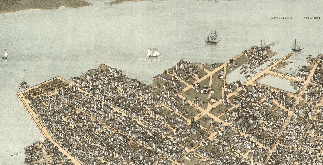
Today’s program is Part 2 of a brief history of one of Charleston’s most iconic landmarks, generally called “the Battery.” In last week’s program, we discussed a series of building campaigns between the 1720s and the 1850s in which our local government gradually transformed the southernmost point of the Charleston peninsula, called White Point, from a sandy beach into scenic high ground. The so-called “High Battery,” that granite seawall protecting East Battery Street, looks today pretty much like it did by the end of the 1850s, after generations of building and rebuilding. Then, just a few years before South Carolina seceded from the Union, Charleston’s city leaders began planning a massive new project, to continue the seawall further westward, to extend White Point Garden, and to build a scenic promenade around the west side of the peninsula. That ambitious antebellum plan was derailed by a series of misfortunes, but it laid the groundwork for a dream that was finally realized in the 1920s by the completion of the so-called “Low Battery” and Murray Boulevard, and in the 1960s with the construction of Lockwood Drive. Today’s focus on the history of Charleston’s Low Battery begins in the autumn of 1856, when the first notions of extending the seawall westward first appeared on the city’s horizon.
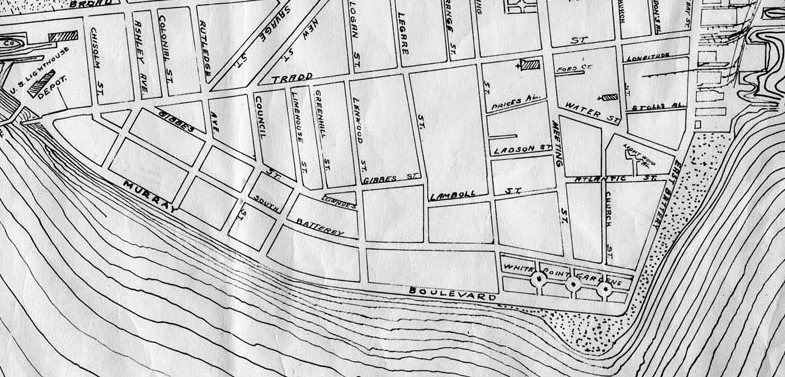
At the close of the year 1856, the City of Charleston was just wrapping up the extensive repairs to the High Battery seawall and White Point Garden made necessary by the destructive hurricane of 1854. Immediately to the west of these expensive public projects, jutting out into the Ashley River, stood a series of rather unsavory private wharves, which the city viewed both as a nuisance and a potential liability to the public park. In late November 1856, Charleston’s mayor, William Porcher Miles, suggested the city could better protect White Point Garden if it were to acquire the property immediately to the west of the park. In early 1857, City Council and the City Attorney pressed hard into this neighboring property, purchasing some land and challenging the legal title of other parcels. By the autumn of 1857, at the end of his two-year term in office, Mayor Miles expressed his desire to see this work continued, to see White Point Garden and its protective seawall extended further to the west across this newly-acquired real estate. His successor, Mayor Charles Macbeth, may have been inclined to sustain the project, but a trio of contrary forces intervened. First, the city found itself embroiled in a public challenge to the city’s legal right to control the property in question. Second, the Panic of 1857 led to a widespread economic contraction. Third, the rising tide of Secession, and then Civil War, usurped the city’s energies and quietly banished all thoughts of expanding White Point Garden for a generation.[1]
The American Civil War devastated the Charleston economy, divided the people, and damaged the local infrastructure. In its aftermath, the City of Charleston was not in a financial position to dream about the westward expansion of White Point Garden and its seawall. In the summer of 1870, the city quietly sold the land it had worked so hard to acquire in 1857, immediately west of White Point Garden between the south ends of King and Legare Streets. Today this property is home to the Fort Sumter House and about a dozen private residences.[2]
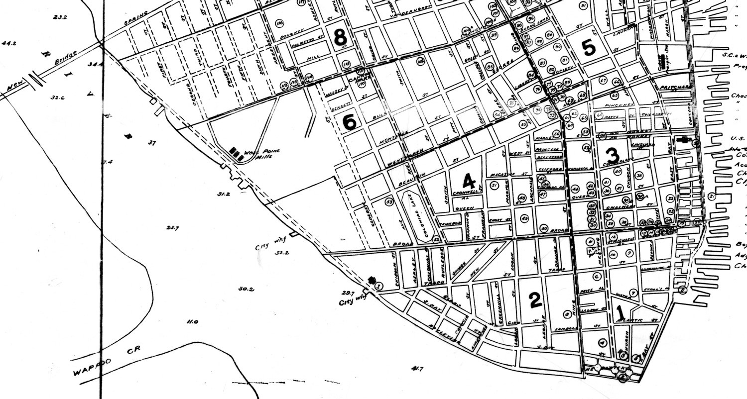
Although the plan to build a new seawall around the Ashley River mudflats stalled in the 1870s, it wasn’t completely forgotten. More than a decade later, in the early months of 1889, Charleston was abuzz with talk of reviving the plan on an even more ambitious scale. Civic leaders and merchants met privately to rally support for a plan, which they agreed to present to City Council in July. Charleston was lagging behind other “progressive cities of the South,” they argued, and the creation of a new seawall and an extensive, scenic boulevard on the city’s west side would impound dozens of acres of mudflats that could be filled to create new, taxable land, and help draw tourists and money to the city. In a memorial to City Council, they asked the city to consider creating “a sea wall promenade or boulevard, from its present terminus to a point west and south of the Chisolm mill property [at the west end of Tradd Street] and continue westwardly the same to the water park belonging to the city and adjoining the New Bridge property [at the west end of Spring Street]. . . . That the property thus reclaimed, or purchased, be laid out in parks, lakes, walks, drives, building lots and sites for industrial and other purposes.”[4]
After three failed attempts to extend a battery seawall around the southwestern edge of the peninsula, in the 1850s, the 1870s, and the early 1890s, the long-dreamed-of project was again revived in the early years of the twentieth century. It happened during the second term of Mayor Robert Goodwyn Rhett, during an era of economic expansion and optimism that brought Charleston out of the post-Civil War doldrums. After years of planning and legal wrangling, the city finally broke ground on the “Boulevard” project in July 1909. In his end-of-the-year address, printed in the Charleston Year Book of 1910, Mayor Rhett observed that “the year 1909 marks the beginning of a new commercial era in Charleston. . . . For more than a half century it has been the dream of our people to extend the Battery westward. The dream, in fuller measure than ever pictured, is now becoming a reality.” The new boulevard behind the new concrete seawall would ultimately extend from White Point Garden as far north as Hampton Park, the mayor confidently stated, but for practical purposes it would have to be done in stages over a number of years.[6]
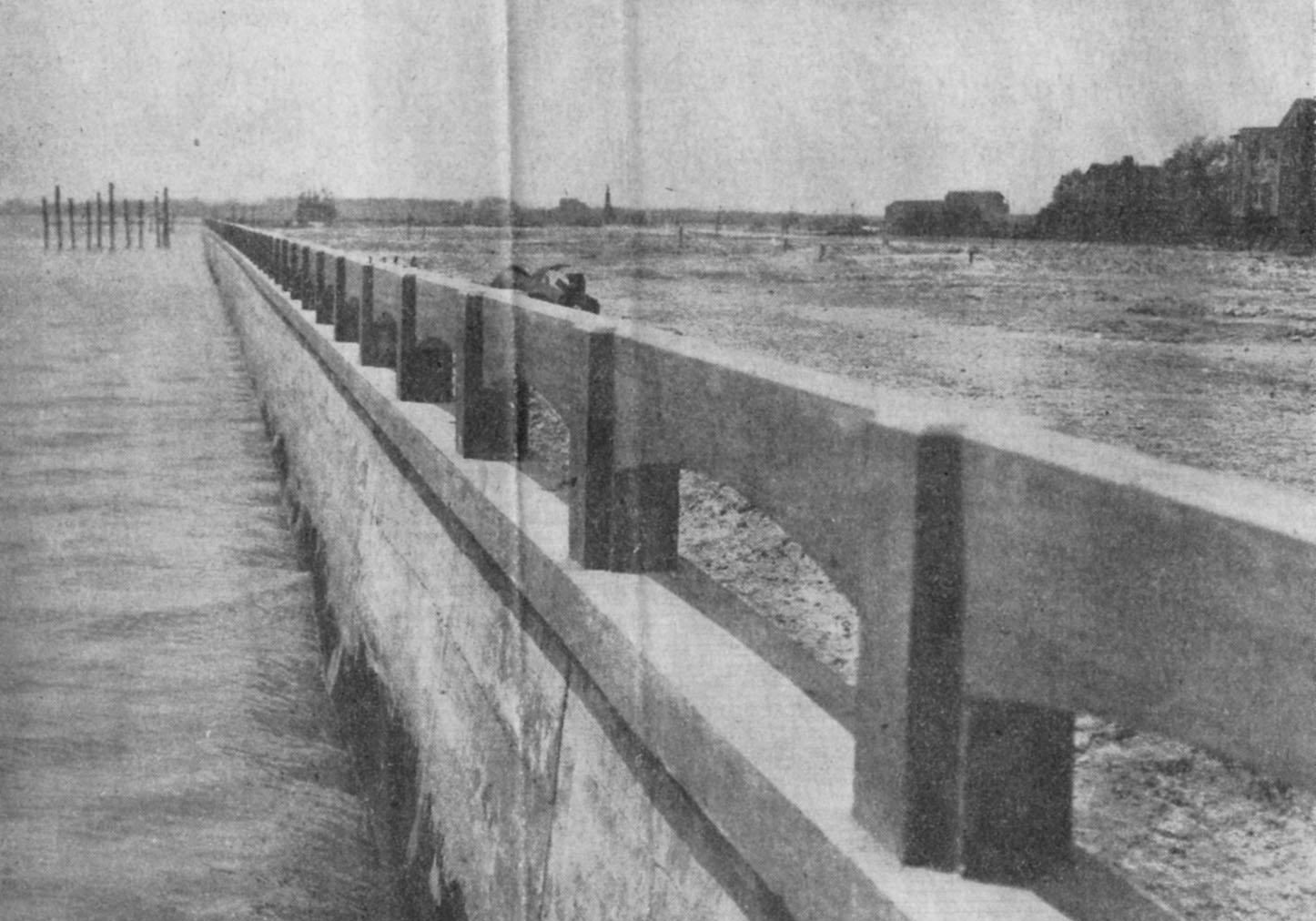
The first stage of the seawall and boulevard project, terminating at the west end of Tradd Street, was completed in December 1911. According to a review of the project in the city Year Book of 1911, in twenty-nine months of construction the McLean Contracting Company of Baltimore built a seawall measuring 3,885 feet long, in the waters of the Ashley River from the south end of King Street to the west end of Tradd Street, and pumped in 667,000 cubic feet of mud from the riverbed to raise the level of the earth behind the seawall. That work, which cost the city just over $261,000, would have been completed earlier, but the dramatic hurricane of August 1911 flooded the new boulevard works, in addition to causing extensive damage to White Point Garden and the old High Battery seawall.[7]
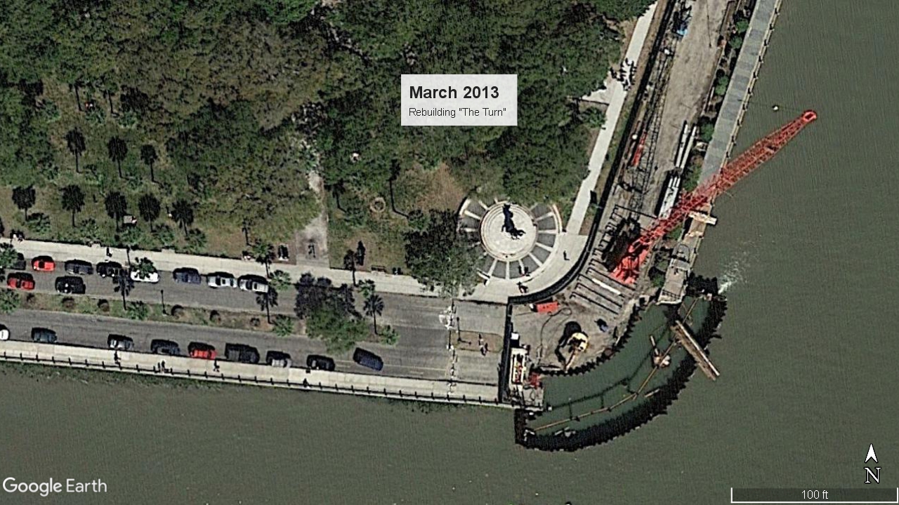
The task of completing the last one thousand feet of new seawall and connecting it to the old High Battery commenced in 1917 and was completed in December 1919. During that period of work, however, the Great War in Europe cast a long shadow over the project. After the United States entered the war in 1917, materials and labor became scarce and continued to be so for several years. In response to these hardships, the seawall engineers cut corners. City reports from the late 1910s document the use of inferior materials and structural shortcuts to build the final phase of the sea wall we call the “Low Battery,” and “the Turn” or rounded corner at the intersection of the new wall and the older “High Battery.” A century later, in the early twenty-first century, these shortcomings matured into significant issues requiring serious attention from the city government.[9]
Meanwhile, back in the early 1920s, a pair of obstacles forced the city to drag its feet on the completion of the last one thousand feet of boulevard through White Point Garden. The cost of the project was prohibitive, so Andrew Murray again offered the city more money to expedite the work. A thornier issue proved to be the prevailing public opposition to the idea of creating a roadway for automobiles through the city’s venerable Battery park. A number of citizens sent angry letters to the city and spoke up at City Council meetings, voicing their dismay at the notion that the city would corrupt such a beautiful garden and destroy such a scenic vista by permitting cars, trucks, and buses to careen around White Point. Such a move would be disrespectful, unsightly, and dangerous for the pedestrians who daily strolled through the gem of Charleston’s parks. Nearly every citizen living nearby signed a petition against the plan, but to no avail. The last stage of “the Murray Boulevard,” as it was then called, was finished in 1922, and vehicles have been looping around White Point Garden ever since.[10]
I think it’s about time for a bit of review. The iconic Charleston landmarks that we call Murray Boulevard and the Low Battery seawall were the fruits of a city-funded project that commenced in 1909 (after five decades of discussion) and ended in 1922. During those thirteen years of construction, the success of the project was tarnished by shortages of materials and labor, and by civic disagreements about the introduction of automobiles into the landscape.
A century later, twenty-first century Charleston is now facing the legacy of those same issues. In late 2013 the city undertook an expensive two-year project to demolish completely and build anew “the Turn,” the rounded corner that connects the High Battery to the Low Battery. The materials and construction techniques used to build the original “Turn” in 1917–1919 were simply insufficient for their intended purpose and had to be replaced. More recently, in the summer of 2017 the City of Charleston unveiled its preliminary ideas for improving the century-old “Low Battery” seawall, and invited citizens to review several options and to submit feedback about design choices. In short, the city is planning to spend millions of dollars on work to strengthen and raise the century-old seawall a bit, improve the landscaping, and perhaps make changes to the flow of automobile traffic along Murray Boulevard as well. The announcement of the city’s proposed improvements garnered a fair amount of public attention over the summer, especially among residents in the immediate neighborhood, but the passing of Hurricane Irma in mid-September brought even more attention to the issues at hand. Irma wasn’t the first storm to send waves crashing over the seawalls that define the southern perimeter of the Charleston peninsula, and it certainly won’t be the last.
[1] See the official proceedings City Council published in Charleston Courier, 27 November 1856; Charleston Mercury, 5 February 1857; Mercury, 18 June 1857; Courier, 3 September 1857; and a brief summary of this 1857 in City Council of Charleston, Year Book, 1880, 103.
[2] The property in question was sold at auction to Henry Buist on 11 July 1870.
[3] City Council of Charleston, Year Book, 1880, 104–5.
[4] Charleston Sunday News, 13 January 1889; Charleston World, 16 June, 20 June, 12 July, 13 July 1889; proceedings of City Council, 29 October 1889, in Charleston News and Courier, 1 November 1889, page 3.
[5] The termination of the boulevard project is mentioned in Charleston Year Book, 1892, 172; Year Book, 1893, 11.
[6] Charleston Year Book, 1909, xiii–xiv, 151–52, 246.
[7] Charleston Year Book, 1910, 151–52; 246; Year Book, 1911, 178–80, 246–47, 250.
[8] Charleston Year Book, 1916, xix–xx; 340; Year Book, 1917, 239–41.
[9] Charleston Year Book, 1918, 139–45; Year Book, 1919, xxiv, 139–40. The Records Management division of the City of Charleston has a 1918 engineer’s day book documenting the construction of the seawall east of King Street.
[10] The city’s Records Management division holds a collection of letters, 1917–19, from a number of citizens objecting to the proposed introduction of automobiles into and through White Point Garden. The completion of the boulevard is described in City Council proceedings of 10 October 1922, published in News and Courier, 14 October 1922, pages 6–7; Charleston Year Book, 1922, 130, 375–76.
[11] Charleston Year Book, 1926, xxx–xxxi; City Council proceedings of 11 March 1930, in Charleston Evening Post, 13 March 1930, page 2A.
NEXT: Captain Anson and the Spanish Entourage
PREVIOUSLY: A Brief History of the High and Low Battery Seawalls, Part 1
See more from Charleston Time Machine